

Avalanche Advisory
| Advisory: Uintas Area Mountains | Issued by Craig Gordon for December 30, 2012 - 5:58am |
|---|


Above treeline
Near treeline
Below treeline
|
bottom line Terrain to avoid- Steep, rocky, upper elevation slopes where pockets of CONSIDERABLE danger exist and human triggered avalanches are likely. In general you'll find a MODERATE avalanche danger and human triggered avalanches are possible on wind drifted slopes. LOW avalanche danger is found in low and mid elevation, wind sheltered terrain.
|

 |
current conditions Clouds continue to spill into the region as a weak storm system slides to the south of our area. Southwest winds are blowing 10-20 mph along the ridges and temperatures are in the mid teens. The recent series of storms has been good to the eastern front and the Uintas have gone from zero to hero. The riding and turning conditions are about as good as they get. Recent observations can be found here. Wondering why last winter was so crazy? Click here to watch the 2011-12 Utah Winter Review... an excellent recap of last years conditions. |
 |
recent activity
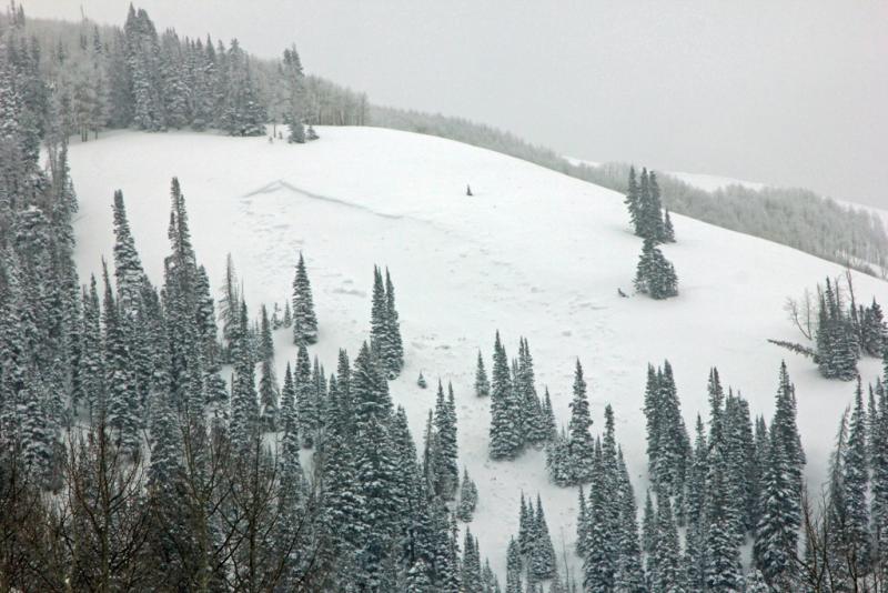
This natural avalanche was discovered on a mid elevation slope in Weber Canyon. There's a broad flat slope to the lookers right of the picture and Wednesday's strong east-southeast winds had no problem forming a huge wind drift on this steep, west-northwest aspect. The slide would definitely ruin your day. Breaking 4 ft deep x 300 ft wide near the ground to facets on an early season raincrust. In addition, collapsing in shallow snowpack regions continues. |
Avalanche Problem 1over the next 24 hours
| type | aspect/elevation | characteristics |
|---|
 |
Above treeline
Near treeline
Below treeline
|
|
|
description
Wow... winter finally arrived in the Uintas and the place is white! Overall, the snowpack appears to be gaining strength and riders are getting into steep terrain without incident. However, given the complexity of our snowpack I wouldn't rule out the possibility of an avalanche breaking deeper and wider than you might expect, especially where snow depths remain shallow and the underlying terrain is steep and rocky. As a matter of fact, this is exactly the type of terrain that we're still hearing loud collapses and seeing shooting cracks. Steep, rocky, mid and upper elevation terrain remains suspect and should be approached with caution. If your travels take you into this type of terrain today carefully assess the snowpack, only put one person on the slope at a time, and above all think about the consequences of triggering an avalanche.
.
|

Avalanche Problem 2over the next 24 hours
| type | aspect/elevation | characteristics |
|---|
 |


Above treeline
Near treeline
Below treeline
|
|
|
description
Fresh wind drifts along the leeward side of upper elevation ridges remain manageable and predictable. One wild card is- once triggered, shallow soft slabs have the potential to break into deeper buried weak layers as they crash down onto the slope below. This chain of events would quickly turn a manageable avalanche into something you didn't bargain for. Best to play it safe and avoid steep, wind drifted slopes. |

 |
weather Clouds, a few flurries, and light winds are on tap for today. Temperatures climb into the upper teens before diving into the single digits overnight. High pressure builds for the upcoming week giving us mostly sunny skies, light winds, and warming temperatures. |
| general annoucements Remember your information can save lives. If you see anything we should know about, please participate in the creation of our own community avalanche advisory by submitting snow and avalanche conditions. You can call me directly at 801-231-2170, email [email protected], or email by clicking HERE This is a great time of year to schedule a free avalanche awareness presentation for your group or club. You can contact me at 801-231-2170 or email [email protected] Donate to your favorite non-profit –The Friends of the Utah Avalanche Center. The UAC depends on contributions from users like you to support our work. The information in this advisory is from the US Forest Service which is solely responsible for its content. This advisory describes general avalanche conditions and local variations always occur. The information in this advisory expires 24 hours after the date and time posted, but will be updated by 7:00 AM Wednesday January 2nd. |