

Avalanche Advisory
| Advisory: Uintas Area Mountains | Issued by Craig Gordon for December 15, 2012 - 5:47am |
|---|


Above treeline
Near treeline
Below treeline
|
bottom line Terrain to avoid- mid and upper elevation leeward slopes, especially those with an easterly component to their aspect. A MODERATE avalanche danger exists on steep wind loaded slopes and human triggered avalanches are possible. LOW avalanche danger exists on wind sheltered slopes.
|

 |
special announcement Mirror Lake Highway is closed and plowing is done for the season. Wolf Creek Pass remains open and is probably a bit of a mess this morning, but don't let the easy access to nearby terrain lull you into a false sense of security. Be prepared for your own self rescue. Wear and know how to use a beacon, shovel, and probe. |
 |
current conditions Skies are mostly cloudy and light snow continues to fall in the wake of last nights cold front. A pretty evenly disbursed 4" of snow fell throughout the range and it looks like more is on the way! Temperatures are in the mid 20's and winds are light and westerly even along the high peaks with hourly averages in the low teens. The riding and turning conditions are finally starting to improve. While upper elevation terrain remains a bit thin and rocky, smooth, wind protected slopes at mid elevations are gonna be the ticket today. Recent snow and avalanche observations can be found here. Wondering why last winter was so crazy? Click here to watch the 2011-12 Utah Winter Review... an excellent recap of last years conditions. |
 |
recent activity Plenty of loud booming collapses are being reported, particularly in regions where the snowpack remains thin and shallow.
Yikes... Ted found this large natural in upper Weber Canyon, just west of Moffit Peak. Breaking to the ground on weak, shallow snow, looks like it released from the strong winds on 12-12-12. |

Avalanche Problem 1over the next 24 hours
| type | aspect/elevation | characteristics |
|---|
 |
Above treeline
Near treeline
Below treeline
|
|
|
description
Today's wind drifts are the most obvious of today's avalanche problems. Easy to detect by their rounded appearance, they'll also be easy to manage and will break around or just below your skis, board, or sled. Once initiated though, today's shallow slabs can quickly get out of hand, breaking into deeper buried weak layers as they crash down onto the slope below.
|

Avalanche Problem 2over the next 24 hours
| type | aspect/elevation | characteristics |
|---|
 |
Above treeline
Near treeline
Below treeline
|
|
|
description
Less obvious and more difficult to manage are avalanches that break into weak snow now buried several feet deep in the snowpack. Granted, the snowpack structure is getting complicated and with a series of storms headed our way it's gonna get more tricky over the next few days. Rather than get caught up in the technical aspects, let's get back to basics. We're starting to see the in your face telltale signs coming together... booming collapses, shooting cracks, and avalanches are natures way of saying the snowpack is sketchy If you're getting onto steep, upper elevation slopes, especially those with an easterly component to their aspect, carefully assess the snowpack and think about the consequences of triggering a slide. Click here to view our observations along with a short video explaining what we're seeing.
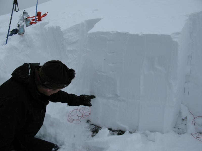
Ted points to our problem child... a layer of weak snow now buried a couple feet deep in our snowpack. |
 |
weather Snow should become more showery in nature this morning and we should see a break in the action by around lunchtime. Westerly winds remain light and temperatures don't vary much from where we're at this morning. Overnight lows dip into the single digits. Another wave slides into the region on Sunday, bringing colder air with 2"-5" of snow expected. Sunday night and Monday it gets interesting with rising temperatures, dense snow, and strong westerly winds. |
| general annoucements Remember your information can save lives. If you see anything we should know about, please participate in the creation of our own community avalanche advisory by submitting snow and avalanche conditions. You can call me directly at 801-231-2170, email [email protected], or email by clicking HERE This is a great time of year to schedule a free avalanche awareness presentation for your group or club. You can contact me at 801-231-2170 or email [email protected] Donate to your favorite non-profit –The Friends of the Utah Avalanche Center. The UAC depends on contributions from users like you to support our work. The information in this advisory is from the US Forest Service which is solely responsible for its content. This advisory describes general avalanche conditions and local variations always occur. The information in this advisory expires 24 hours after the date and time posted, but will be updated by 7:00 AM Sunday December 16th. |