| Please join us at the 23rd annual Black Diamond Fall Fundraiser Party Thursday Sept 15. Tickets are on sale now here, at the Black Diamond store & at REI. Special bonus raffle for online ticket purchasers! |
| Please join us at the 23rd annual Black Diamond Fall Fundraiser Party Thursday Sept 15. Tickets are on sale now here, at the Black Diamond store & at REI. Special bonus raffle for online ticket purchasers! |
| Advisory: Skyline Area Mountains | Issued by Brett Kobernik for Saturday - February 20, 2016 - 6:57am |
|---|


|
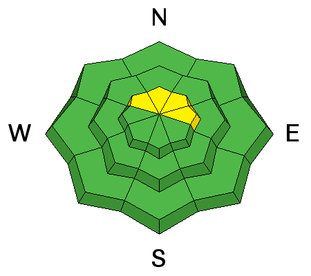
bottom line Heads up people! Dangerous conditions still exist on certain slopes. Upper elevation north through east facing slopes approaching 40 degrees in steepness that have already avalanched this season may avalanche again today if provoked. The avalanche danger is MODERATE for these slopes. It's a "high consequence/low probability" situation. There's a low probability of triggering one but high consequences if you do. Outside of the terrain described above, the danger is generally LOW.
|
 |
current conditions Riding conditions are decent with a few new inches of snow that fell on Thursday. Wind was very strong for a few hours before the snowfall on Thursday which snapped a few larger trees. A clear day on Friday allowed the sunny slopes to become damp in some locations. Wind was southerly in the moderate speed range on Friday and has slowed a bit more overnight. |
 |
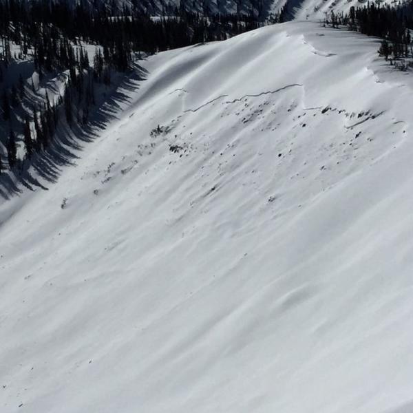
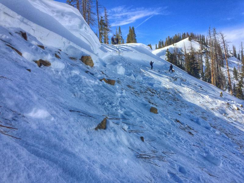
recent activity Our staff found a couple of notable avalanches on Friday. First was one most likely triggered by a snowmobiler last weekend. It was at the head of Seeley Creek on a slope that had avalanched in December. CLICK HERE FOR MOR DETAILS
The second was triggered by a snowmobiler on Friday in Rolfson Canyon. He triggered it at the apex of a hill climb and saw the slope fracture. He was able to pull his airbag and then get a hold of the bars again and keep the sled upright as he rode the sled on top of the debris for most of the way down the hill and then was able to get in front of the debris and out run it. The slide was 3 to 5 feet deep and about 300 feet wide and ran about 1000 feet. We do not know for certain if the slope avalanched earlier this season. However, it more than likely did run judging by the overall shallow nature of this slope at this time of the season. CLICK HERE FOR MORE DETAILS
Video of avalanche in Rolfson Canyon on the Skyline from Trent Meisenheimer on Vimeo.
|
| type | aspect/elevation | characteristics |
|---|

|
|
LIKELIHOOD
 LIKELY
UNLIKELY
SIZE
 LARGE
SMALL
TREND
 INCREASING DANGER
SAME
DECREASING DANGER
|
|
description
This is a tough situation this season. Avalanche paths that have released earlier this year and are filled back in continue to be dangerous. A few human triggered avalanches each week continues to demonstrate this. The easiest way to avoid trouble is to avoid the higher north through east facing slopes that are steeper than 35 degrees. Unfortunately, this terrain holds a lot of our favorite riding. Slopes that haven't avalanched at all this season probably won't break to the ground at this point. However, unless you are 100% sure a slope hasn't slid, you're rolling the dice. The other thing that is tricky is that things are not "hair trigger" out there. Not everything you touch is going to slide. I've seen tracks on many slopes that I thought should have avalanched. Tracks on a slope don't mean they're safe. If they've already avalanched this season, there's a good chance they'll go again. |
 |
weather Looks like nice weather shaping up for the weekend. We'll see sun with a few scattered clouds and ridgetop high temperatures today in the mid 30s. West northwest wind should be light to moderate in speed. Sunday should be fairly similar. A small storm may give us a few inches of snow Monday night into Tuesday. It looks very windy during this period. After that, weather models are not currently showing any large storms in the future. |
| general announcements We will publish full detailed advisories Saturday and Sunday mornings by 7am. We will also be publishing basic avalanche danger ratings & info during the week. If you are getting out into the mountains, we love to hear from you! You can SUBMIT OBSERVATIONS ONLINE or EMAIL US If you would like to have avalanche advisories emailed to you, SIGN UP HERE We can provide basic avalanche awareness presentations for your school, group or club. To enquire, CLICK HERE |