
| During the month of April, Mark Miller will donate $75 to the charity of your choice (5 to chose from, including the Utah Avalanche Center!) Mark Miller Subaru has raised over $300k in the previous 6 Do Good Feel Good events. More Info here |  |
| During the month of April, Mark Miller will donate $75 to the charity of your choice (5 to chose from, including the Utah Avalanche Center!) Mark Miller Subaru has raised over $300k in the previous 6 Do Good Feel Good events. More Info here | |
| Advisory: Skyline Area Mountains | Issued by Craig Gordon for Tuesday - March 3, 2015 - 6:21am |
|---|

|
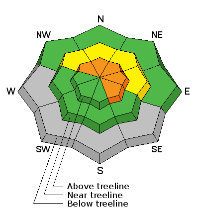
bottom line At and above treeline on steep wind drifted slopes facing the north half of the compass, you'll find a CONSIDERABLE avalanche danger. Human triggered avalanches are likely and natural avalanches possible. Any slide triggered today has the potential to break deeper and wider than you might expect, resulting in a deep, dangerous slide. Mid elevation terrain offers MODERATE avalanche danger and human triggered avalanches are possible on steep wind drifted slopes. Most other terrain offers a LOW avalanche danger.
|
 |
special announcement NEW THIS YEAR: You can now receive advisories by email for each region in the state. Go here for details. |
 |
current conditions The Skyline finally got a little white love! Over a foot has stacked up near the summit and another good shot of snow and water is on the way in the next couple hours. West and southwest winds gusted in the 30's yesterday, but have mellowed somewhat this morning, blowing in the teens and 20's. Temperatures are in the low to mid 20's. Visibility will be an issue today for sure, especially with all the new snow flying over-the-hood and in your face! |
 |
recent activity No new avalanche activity to report |
| type | aspect/elevation | characteristics |
|---|

|
|
LIKELIHOOD
 LIKELY
UNLIKELY
SIZE
 LARGE
SMALL
TREND
 INCREASING DANGER
SAME
DECREASING DANGER
|
|
description
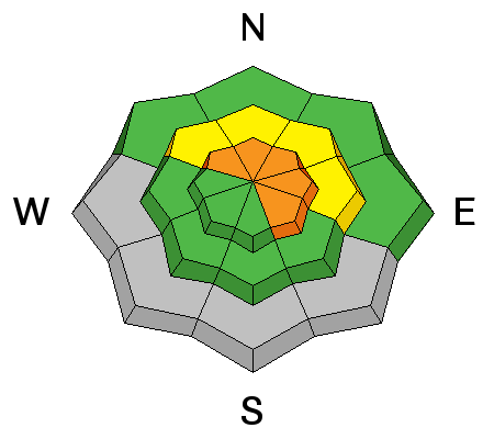
The avalanche danger changed drastically overnight and for the moment, our days of Low danger and big terrain choices have gotta be put on hold. Fresh wind slabs are gonna be today's most obvious avalanche problem and it's because a cohesive layer of snow formed on top of the light, fluffy powder from this weekends storm. With more snow and wind on the way in the next couple hours, I bet today's slabs will break deeper and wider than you might expect and they'll be packing a punch. Today you'll want to avoid steep, wind drifted slopes, especially those facing the north half of the compass. Remember- shooting cracks are a big clue to unstable snow and you'll definitely want to avoid any fat, rounded pillows of snow. Lose a little elevation, head to mid elevation sheltered terrain and you'll be rewarded with deep snow and manageable avalanche danger.
|
| type | aspect/elevation | characteristics |
|---|

|

|
LIKELIHOOD
LIKELY
UNLIKELY
SIZE
LARGE
SMALL
TREND
INCREASING DANGER
SAME
DECREASING DANGER
|
|
description
While not widespread and hard to detect, there are pockets of sugary snow near the ground, especially in upper elevation terrain facing East, North, and Northeast. This storm has all the ingredients to bring those dormant weak layers back to life. Once triggered, today's avalanches have the potential to break to weak snow near the ground, particularly in steep, rocky terrain. A slide of this nature is gonna be deep, wide, and certainly unmanageable. With all the good options for riding today, there's no reason to pull on the dogs tail. A little patience goes a long way in the mountains... it's spring after-all and in a few days the avalanche danger will become more predictable. |
 |
weather A break in the action early this morning with more snow on the way. A foot is a good bet before things rapidly wind down late in the day. Winds veer to the Northwest and blow in the 20's and 30's along the high ridges. Temperatures climb into the mid and upper 20's before diving into the single digits overnight. High pressure returns for the rest of the week with sunny skies and warming temperatures. |
| general announcements Donate to your favorite non-profit –The Utah Avalanche Center. The UAC depends on contributions from users like you to support our work. Benefit the Utah Avalanche Center when you buy or sell on ebay - set the Utah Avalanche Center as a favorite non-profit in your ebay account here and click on ebay gives when you buy or sell. You can choose to have your seller fees donated to the UAC, which doesn't cost you a penny. Utah Avalanche Center mobile app - Get your advisory on your iPhone along with great navigation and rescue tools. The information in this advisory is from the US Forest Service which is solely responsible for its content. This advisory describes general avalanche conditions and local variations always occur. This advisory will be updated by 7:00 AM Saturday, March 7, 2015 or sooner if conditions warrant. |


.jpg)
