
| During the month of April, Mark Miller will donate $75 to the charity of your choice (5 to chose from, including the Utah Avalanche Center!) Mark Miller Subaru has raised over $300k in the previous 6 Do Good Feel Good events. More Info here |  |
| During the month of April, Mark Miller will donate $75 to the charity of your choice (5 to chose from, including the Utah Avalanche Center!) Mark Miller Subaru has raised over $300k in the previous 6 Do Good Feel Good events. More Info here | |
| Advisory: Skyline Area Mountains | Issued by Craig Gordon for Saturday - February 21, 2015 - 5:42am |
|---|

|
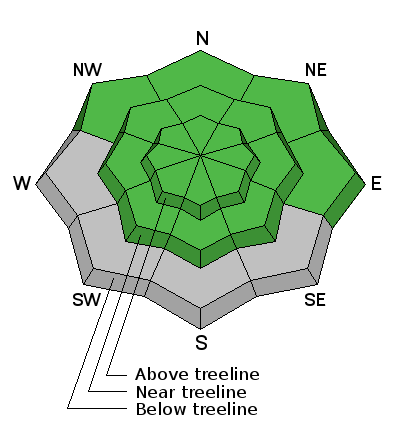
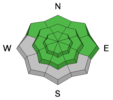
bottom line Most terrain has a LOW avalanche danger this weekend.
|
 |
special announcement RESEARCH PROJECT ON UNDERSTANDING TRAVEL BEHAVIOR IN AVALANCHE TERRAIN NEEDS YOU! Scientists from the Snow and Avalanche Lab at Montana State University are seeking more participants for their project examining decision making and travel in avalanche terrain. Their project aims to collect GPS location information (from your smartphone) and survey responses from backcountry skiers and riders to better understand what types of terrain are used and how decisions are made. Their focus is on backcountry skiers and riders of all abilities and experience. For more information: www.montana.edu/snowscience/tracks For snowmobilers: www.montana.edu/snowscience/sleds We just released an exciting, new avy safety video designed specifically for snowmobilers - Knowledge is Powder. https://vimeo.com/113677686 NEW THIS YEAR: You can now receive advisories by email for each region in the state. Go here for details. |
 |
current conditions A storm system slid through the region overnight, delivering a much needed inch or two of new snow. Temperatures are in the low to mid 20's and winds are southwesterly, blowing 10-20 mph along the summit. Man... it's been pretty underwhelming out there the past few weeks, but a little snow will go a long way to improve spirits and help soften old tracks. However, the big picture is a little bit of a buzz-kill as overall coverage remains pretty boney.
|
 |
recent activity No new avalanche activity to report |
| type | aspect/elevation | characteristics |
|---|

|
|
LIKELIHOOD
 LIKELY
UNLIKELY
SIZE
 LARGE
SMALL
TREND
 INCREASING DANGER
SAME
DECREASING DANGER
|
|
description
The snowpack is generally stable, but here are a couple of things to keep in mind:
|
 |
weather A storm dives to our south and I think an additional couple of inches of snow is all we'll see as a result. Temperatures climb into the low 30's and winds should remain pretty well behaved.... in the mid to upper 20's along the high peaks. Maybe a snow shower or two overnight before skies begin to clear on Sunday. Looks like more storms on tap for the upcoming week. No huge snow totals, but enough to freshen things up. |
| general announcements Donate to your favorite non-profit –The Utah Avalanche Center. The UAC depends on contributions from users like you to support our work. Benefit the Utah Avalanche Center when you buy or sell on ebay - set the Utah Avalanche Center as a favorite non-profit in your ebay account here and click on ebay gives when you buy or sell. You can choose to have your seller fees donated to the UAC, which doesn't cost you a penny. Utah Avalanche Center mobile app - Get your advisory on your iPhone along with great navigation and rescue tools. The information in this advisory is from the US Forest Service which is solely responsible for its content. This advisory describes general avalanche conditions and local variations always occur. This advisory will be updated by 7:00 AM Saturday, February 28, 2015 or sooner if conditions warrant. |


.jpg)
