| During the month of April, Mark Miller will donate $75 to the charity of your choice (5 to chose from, including the Utah Avalanche Center!) Mark Miller Subaru has raised over $300k in the previous 6 Do Good Feel Good events. More Info here |  |
| During the month of April, Mark Miller will donate $75 to the charity of your choice (5 to chose from, including the Utah Avalanche Center!) Mark Miller Subaru has raised over $300k in the previous 6 Do Good Feel Good events. More Info here | |
| Advisory: Skyline Area Mountains | Issued by Craig Gordon for Sunday - December 28, 2014 - 6:17am |
|---|

|
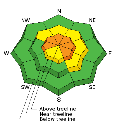
bottom line At upper elevations at and above treeline, the avalanche danger is CONSIDERABLE. While not widespread, human triggered avalanches are probable on steep, wind drifted slopes facing the north half of the compass. Any slide triggered today has the potential to break deep and wide, resulting in a dangerous avalanche. A MODERATE avalanche danger exists on recently wind loaded slopes at mid elevations and human triggered avalanches are possible A LOW avalanche danger exists on low and mid elevation slopes facing the south half of the compass and terrain that had no pre-existing snow prior to last weeks big storm.
|
 |
special announcement We just released an exciting, new avy safety video designed specifically for snowmobilers - Knowledge is Powder. https://vimeo.com/113677686 NEW THIS YEAR: You can now receive advisories by email for each region in the state. Go here for details.
|
 |
current conditions Clouds rolled into the region late yesterday and westerly winds increased around dinner time, blowing steadily through the night in the mid 20's along the high ridges. Temperatures are in the low to mid teens. The riding and turning conditions are amazing, especially on mid elevation, wind sheltered slopes.
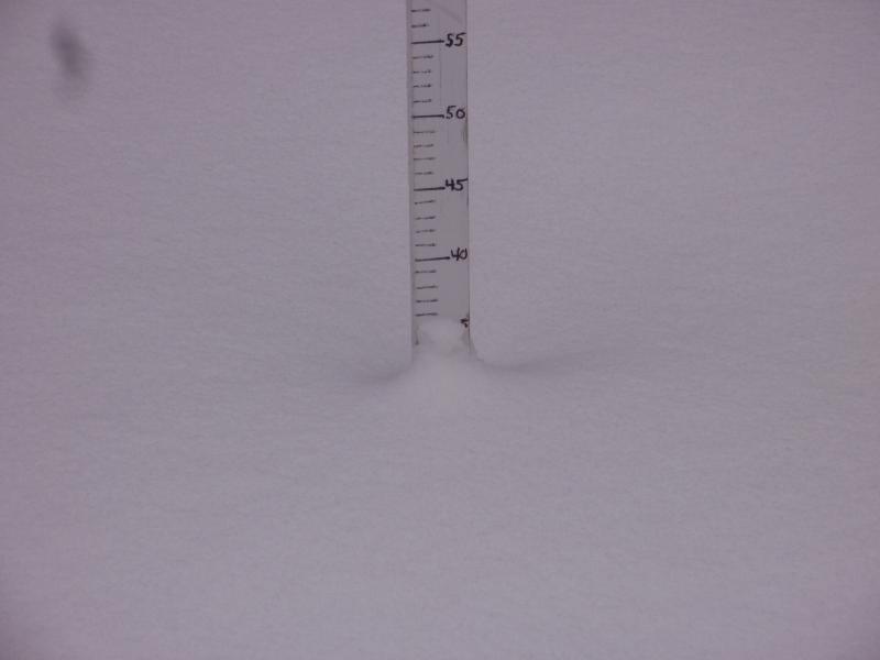
Thirty five CM new at Millers flat with a total depth of 110 CM
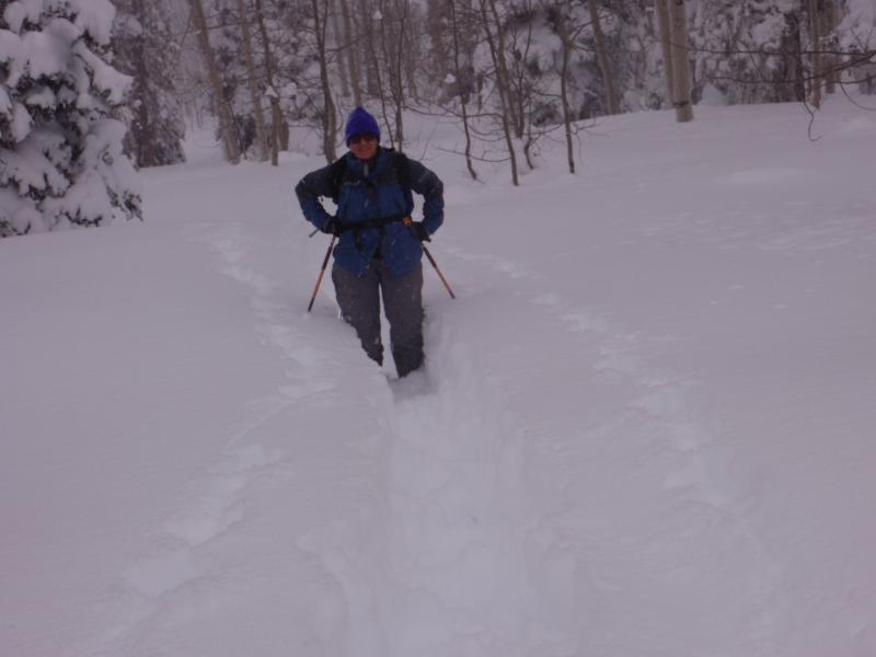
It's deep out there! Steve Cote breaking trail in knee deep, Skyline fluff Friday. More details on his outing can be found here. |
 |
recent activity No recent avalanche activity to report
|
| type | aspect/elevation | characteristics |
|---|

|
|
LIKELIHOOD
 LIKELY
UNLIKELY
SIZE
 LARGE
SMALL
TREND
 INCREASING DANGER
SAME
DECREASING DANGER
|
|
description
Lots of steep terrain throughout the range saw tracks yesterday and in general the snowpack appears pretty well behaved. The good news is... no avalanches on steep slopes. The bad news... the snowpack structure suggests we're not quite at green light conditions just yet and that's exactly the problem when we're dealing with persistent slabs. They're deceptive, not so easy to detect, and even less manageable. Here's a great video illustrating why they're so dangerous. Winds picked up overnight, there's plenty of light density snow to blow around, and today, many slopes are fat and loaded. Any avalanche triggered today, still has the potential to break deep and wide, producing a large and dangerous slide. Avoid steep wind drifted terrain and you avoid the problem |
 |
weather A good shot of snow develops later today, and westerly winds bump into the 30's along the high ridges. Temperatures barely climb into the mid teens and dip into the single digits overnight. Winds decrease late tonight, the storm starts to wind down, and storm totals look to be in the 12" range by Monday morning. Snow showers linger Monday and then the region dries out and cold air filters into the area with highs barely breaking out of the single digits. Computer models suggest stormy weather for the end of the week.
|
| general announcements We're still interested in snow and avalanche information. If you see anything we should know about, please participate in the creation of our own community avalanche advisory by submitting snow and avalanche conditions. You can call me directly at 801-231-2170, email [email protected], or email by clicking HERE Donate to your favorite non-profit –The Utah Avalanche Center. The UAC depends on contributions from users like you to support our work. Benefit the Utah Avalanche Center when you buy or sell on ebay - set the Utah Avalanche Center as a favorite non-profit in your ebay account here and click on ebay gives when you buy or sell. You can choose to have your seller fees donated to the UAC, which doesn't cost you a penny. Utah Avalanche Center mobile app - Get your advisory on your iPhone along with great navigation and rescue tools. The information in this advisory is from the US Forest Service which is solely responsible for its content. This advisory describes general avalanche conditions and local variations always occur. I will update this advisory by 7:00 AM Saturday Jan. 3, 2015 or sooner if conditions warrant. |


.jpg)