| During the month of April, Mark Miller will donate $75 to the charity of your choice (5 to chose from, including the Utah Avalanche Center!) Mark Miller Subaru has raised over $300k in the previous 6 Do Good Feel Good events. More Info here |  |

For every car Mark MIller Subaru sells in April, they will donate $75 to the charity of your choice (5 to choose from). Who are you going to choose? Plus - you can vote for your favorite and the 3 groups receiving the most votes get an additional cash prize donated by Mark Miller Subaru. Details here

| During the month of April, Mark Miller will donate $75 to the charity of your choice (5 to chose from, including the Utah Avalanche Center!) Mark Miller Subaru has raised over $300k in the previous 6 Do Good Feel Good events. More Info here |  |
| Advisory: Skyline Area Mountains | Issued by Brett Kobernik for Friday - January 31, 2014 - 8:08pm |
|---|
 |
current conditions Yes!!! Nice shot of snow for the Skyline over the last couple of days. The northern portion of the Skyline has about 10-12" of settled storm snow since Wednesday containing 1 to 2 inches of water. There was not much wind involved with this storm. We did notice a few moderate speed gusts late Friday afternoon while above 10,000'. Temperatures are dropping from the 20s into the teens Friday night. The new snow made travel on snowmachines difficult. Actually, the very weak unconsolidated old snow is the problem. Once you punch through the new snow into old weak sugary snow you are pretty deep into it. Snowmobile tracks punching into weak sugar is a huge red flag to avalanche instability. Below are a couple of observations from Friday. Thanks Darce and Steve!! |
 |
recent activity No avalanche activity was reported over the last week. We did not note any natural activity from the storm but visibility was not the best and travel was fairly difficult not allowing us to check out a whole lot of terrain. |
| type | aspect/elevation | characteristics |
|---|


|


|

LIKELIHOOD
 LIKELY
UNLIKELY
SIZE
 LARGE
SMALL
TREND
 INCREASING DANGER
SAME
DECREASING DANGER
|
|
description
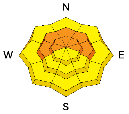
We experienced lots of collapsing Friday when we walked around on skis. The type of collapsing that makes you pucker even when you're on low angle slopes. The Skyline has some of the weakest snow I've seen at this time of the season in years. Any new snow load from a storm is suspect. While this was a good storm, it wasn't huge. Absence of natural activity may lure a person into thinking the avalanche danger is not present. Steep slopes are not safe right now. A poor snowpack structure with a decent new load of snow trumps everything. We will be playing on low angle slopes through the weekend. Winds have been unusually light and look like they won't get that strong through the weekend. However, keep in mind that any increase in wind speed will drift the low density snow and dramatically increase the avalanche danger on lee slopes. |
 |
weather We'll see mostly cloudy skies on Saturday with highs in the teens. We may see a few snow showers. No significant accumulation is expected. Ridgetop winds will be from the northwest and moderate in speed. Highs will be in the teens. Sunday looks like a nicer day with slightly warmer temperatures and only partly cloudy skies. Northwest winds again look moderate in speed. |
| general announcements Donate to your favorite non-profit –The Utah Avalanche Center. The UAC depends on contributions from users like you to support our work. Benefit the Utah Avalanche Center when you buy or sell on ebay - set the Utah Avalanche Center as a favorite non-profit in your ebay account here and click on ebay gives when you buy or sell. You can choose to have your seller fees donated to the UAC, which doesn't cost you a penny. Utah Avalanche Center mobile app - Get your advisory on your iPhone along with great navigation and rescue tools. The information in this advisory is from the US Forest Service which is solely responsible for its content. This advisory describes general avalanche conditions and local variations always occur. This advisory will be updated by 7:00 AM Saturday, February 8th, 2014. |
Advisory Hotline: (888) 999-4019 | Contact Information