
| During the month of April, Mark Miller will donate $75 to the charity of your choice (5 to chose from, including the Utah Avalanche Center!) Mark Miller Subaru has raised over $300k in the previous 6 Do Good Feel Good events. More Info here |  |
| During the month of April, Mark Miller will donate $75 to the charity of your choice (5 to chose from, including the Utah Avalanche Center!) Mark Miller Subaru has raised over $300k in the previous 6 Do Good Feel Good events. More Info here | |
| Advisory: Skyline Area Mountains | Issued by Brett Kobernik for Saturday - January 4, 2014 - 6:32am |
|---|

|
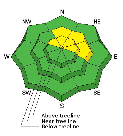
bottom line There is a MODERATE avalanche danger along the mid and high elevation windy terrain. Human triggered avalanches are possible. Steep northeast and east facing slopes are the most dangerous. Out of the wind, the avalanche danger is mostly LOW.
|
 |
current conditions We're seeing a little bit of snow right now on the Skyline but not enough for any accumulation yet. West and northwest winds picked up mid day yesterday and have continued. This was creating some small drifts along the ridges on east facing slopes. You'll find wind crusts in the higher exposed locations. There is plenty of soft settled snow out of the higher windy terrain. Temperatures are in the upper teens to low 20s. The snowpack averages about 2 feet in depth along the mid and upper elevations. It is quite weak and you'll find your sled track dropping through into sugary snow in many areas. |
| type | aspect/elevation | characteristics |
|---|

|
|
LIKELIHOOD
 LIKELY
UNLIKELY
SIZE
 LARGE
SMALL
TREND
 INCREASING DANGER
SAME
DECREASING DANGER
|
|
description
The biggest concern today is going to be along the lee side of any slope that is getting hit by the wind. The wind may have drifted enough snow to overload the buried weak sugary snow. This avalanche problem is going to be spotty and mainly confined to the easterly facing higher ridgelines. Much of this terrain is not currently accessible on a snowmobile due to thin snow cover, so it probably won't pose much threat to people out there today. However, if you do find yourself getting into the high windy terrain, be cautious. A wind loaded slope that breaks into buried weak sugary snow will be dangerous. |
 |
weather We'll see a little snow today with only around and inch or two of accumulation. West and northwest winds will continue to be in the moderate speed category with stronger gusts along the ridges. Temperatures will be much colder than the last few days. Skies clear out on Sunday but the winds will continue to blow a bit from the northwest. |
| general announcements general announcements Remember your information can save lives. Please let us and the rest of the community know what you are seeing out there by submitting snow and avalanche conditions. This is a great time of year to schedule a free avalanche awareness presentation for your group or club. Contact either Craig Gordon or Brett Kobernik by emailing us: Donate to your favorite non-profit –The Utah Avalanche Center. The UAC depends on contributions from users like you to support our work. Benefit the Utah Avalanche Center when you buy or sell on ebay - set the Utah Avalanche Center as a favorite non-profit in your ebay account here and click on ebay gives when you buy or sell. You can choose to have your seller fees donated to the UAC, which doesn't cost you a penny. Utah Avalanche Center mobile app - Get your advisory on your iPhone along with great navigation and rescue tools. The information in this advisory is from the US Forest Service which is solely responsible for its content. This advisory describes general avalanche conditions and local variations always occur. |


.jpg)