25th Annual Black Diamond Fall Fundraising Party
Thursday, September 13; 6:00-10:00 PM; Black Diamond Parking Lot
25th Annual Black Diamond Fall Fundraising Party
Thursday, September 13; 6:00-10:00 PM; Black Diamond Parking Lot
| Advisory: Salt Lake Area Mountains | Issued by Mark Staples for Saturday - April 7, 2018 - 6:17am |
|---|

|
bottom line Today the avalanche danger is CONSIDERABLE at mid and upper elevations. Rain yesterday and heavy rain today up to 11,000 feet will cause both wet loose and wet slab avalanches. Most avalanche activity will be wet loose avalanches. However, larger wet slab avalanches may occur as well. It's hard to forecast for wet slab avalanches but they could break 3-6 feet deep and be very destructive. Large glide avalanches are also possible in places like Broads Fork where the snow rest on large rock slabs.
|
 |
special announcement The UAC Marketplace is still open. Our online marketplace still has deals on skis, packs, airbag packs, beacons, snowshoes, soft goods and much more. |
 |
current conditions Since yesterday morning upper Little Cottonwood Canyon received 0.8 inches of precipiation while other areas received 0.3-0.4 inches. 2-3 inches of snow fell yesterday morning snowfall changed to rain as temperatures warmed. By the end of the day, the snow surface was damp up to 10,500 feet. At lower elevations near 8000 feet, the snowpack was saturated and unsupportable. The rain/snow line this morning is at 9300 feet and mountain temperatures range from 30 to 35 degrees F. Westerly winds are averaging 5-10 mph gusting 15-20 mph. The rain/snow line will rise throughout the day with heavy rainfall. See mountain weather at the bottom. Our Week in Review can be found by clicking here, including coverage of a recent avalanche cycle in the Provo mountains. |
 |
recent activity Yesterday, ski patrols in the Cottonwood Canyons easily triggered shallow, wet avalanches and observed natural rollerball activity. Additionally, they reported that rain had started to saturate the thick, hard ice crusts near the snow surface. |
| type | aspect/elevation | characteristics |
|---|

|

|
LIKELIHOOD
 LIKELY
UNLIKELY
SIZE
 LARGE
SMALL
TREND
 INCREASING DANGER
SAME
DECREASING DANGER
|
|
description
The snowpack became saturated yesterday afternoon at low and mid elevations, and the snow surface became wet at upper elevations. Heavy rain up to 11,000 feet will continue to saturate the snowpack and cause wet loose avalanches. The period of greatest instability may be this afternoon when rainfall is heaviest. These will be good triggers for larger deeper slides. See the next section about Wet Slab Avalanches. |
| type | aspect/elevation | characteristics |
|---|

|
|
LIKELIHOOD
LIKELY
UNLIKELY
SIZE
 LARGE
SMALL
TREND
INCREASING DANGER
SAME
DECREASING DANGER
|
|
description
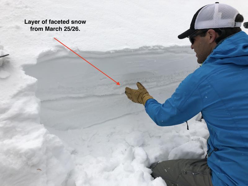
Rain yestereday combined with heavy rain today should cause some large wet slab avalnches. These types of slides are hard to forecast, but we know they are often triggered by small, wet loose avalanches. Some wet slabs may break less than a foot deep on all aspects within several different ice crust and snow layers that formed during the last week. Check out these layers in the photo below. Some wet slabs may break much deeper on buried faceted layers. These layers gained a lot of strength and the snowpack was mostly frozen and strong after rain on March 22 followed by very cold temperatures. Despite this increase in strength, water percolating through the snowpack could awaken these layers and cause wet slab avalanches to break 3-6 feet deep mostly on NW, N and NE aspects where these faceted layers have existed for most of the season. Check out this video from the Sawtooth Avalanche Center in Idaho showing what kind of damage wet slabs can do. HEADS UP - Wet slab avalanches may be hard to predict, but we know they have the ability to run very far downhill, often much further than you'd ever expect.
|
| type | aspect/elevation | characteristics |
|---|
|
|
LIKELIHOOD
 LIKELY
UNLIKELY
SIZE
LARGE
SMALL
TREND
 INCREASING DANGER
SAME
DECREASING DANGER
|
|
description
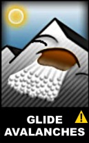
If wet slab avalanches are hard to predict, glide avalanches are even harder. The good news is that they usually occur where a huge crack in the snowpack extends from the snow surface to the ground. We can see these glide cracks and avoid being underneath them. Places like Broad's Fork and Stairs Gulch in Big Cottonwood Canyon with smooth rock slabs are common places for these avalanches to occur. Below is a photo (M. White) of debris from a glide avalanche in Broads Fork that occurred after the last rain event on March 22.
|
 |
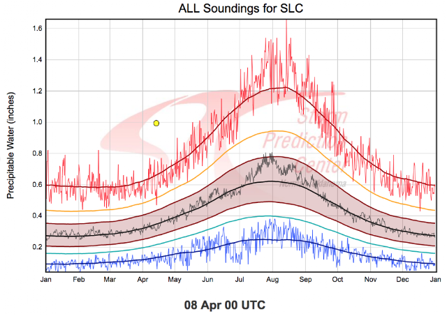
weather Today's weather forecast is simple in terms of avalanches. Heavy rain will fall up to nearly 11,000 feet. The rain/snow line is near 9300 feet this morning but will be rising. The heaviest rain should occur this afternoon. By tomorrow morning 1-1.5 inches of rain should fall. At 9000 feet, temperatures should reach the upper 40's F. Winds should increase some as the cold front approache and blow 10-20 mph gusting 30-40 mph from the SW. Unfortunately, the cold front will pass over the area tonight and not much additional precipitation is expected once temperatures start dropping. Only a few inches of snow should fall by early tomorrow morning. In meteorological terms, this weather event is WAY outside of what is normal. Rain this time of year is normal, but rain at 11,000 feet is not. Jim Steenburgh, University of Utah Atmospheric Sciences Professor, wrote a blog post about this event worth reading. If you don't have time or interest to read his blog, at least look at the graph below. All you need to know is that the red squigly line is the previous record high values for precipitable water. This weather event is the yellow dot and is well above that.
|
| general announcements CLICK HERE FOR MORE GENERAL INFO AND FAQ The UAC has new support programs with Outdoor Research and Darn Tough. Support the UAC through your daily shopping. When you shop at Smith's, or online at Outdoor Research, REI, Backcountry.com, Darn Tough, Patagonia, NRS, Amazon, eBay a portion of your purchase will be donated to the FUAC. See our Donate Page for more details on how you can support the UAC when you shop. Benefit the Utah Avalanche Center when you buy or sell on eBay - set the Utah Avalanche Center as a favorite non-profit in your eBay account here and click on eBay gives when you buy or sell. You can choose to have your seller fees donated to the UAC, which doesn't cost you a penny This information does not apply to developed ski areas or highways where avalanche control is normally done. This advisory is from the U.S.D.A. Forest Service, which is solely responsible for its content. This advisory describes general avalanche conditions and local variations always occur. |


.JPG)