25th Annual Black Diamond Fall Fundraising Party
Thursday, September 13; 6:00-10:00 PM; Black Diamond Parking Lot
25th Annual Black Diamond Fall Fundraising Party
Thursday, September 13; 6:00-10:00 PM; Black Diamond Parking Lot
| Advisory: Salt Lake Area Mountains | Issued by Eric Trenbeath for Saturday - March 3, 2018 - 5:36am |
|---|

|
bottom line The Utah Avalanche Center has issued an avalanche watch for dangerous avalanche conditions developing today and continuing into Monday. The avalanche danger is CONSIDERABLE today at upper elevations, and MODERATE at mid elevations where recently formed wind slabs can be found on all aspects. Look for recent deposits of wind drifted snow on the lee sides of ridge crests and terrain features and avoid steep slopes where they are present. There also remains a MODERATE danger for triggering deeper, persistent slab avalanches on isolated slopes facing W-N-SE, especially on slopes with a thinner snowpack. Backcountry travelers need to be alert to changing conditions and expect a rising danger over the next 24 hours.
|
 |
avalanche watch THE FOREST SERVICE UTAH AVALANCHE CENTER IN SALT LAKE CITY HAS ISSUED A BACKCOUNTRY AVALANCHE WATCH. * TIMING…IN EFFECT FROM 6 AM MST THIS MORNING TO 6 AM MST SUNDAY * AFFECTED AREA…FOR THE MOUNTAINS OF NORTHERN UTAH INCLUDING THE WASATCH RANGE...BEAR RIVER RANGE...AND THE UINTA MOUNTAINS. * AVALANCHE DANGER…THE AVALANCHE DANGER FOR THE WATCH AREA IS CONSIDERABLE AND IS EXPECTED TO RISE TO HIGH BY SUNDAY. * IMPACTS…STRONG WINDS AND HEAVY SNOWFALL WILL CREATE DANGEROUS AVALANCHE CONDITIONS BY EARLY SUNDAY, AND CONTINUING INTO MONDAY. BOTH HUMAN TRIGGERED AND NATURAL AVALANCHES ARE LIKELY. STAY OFF OF AND OUT FROM UNDER SLOPES STEEPER THAN 30 DEGREES. BACKCOUNTRY TRAVELERS SHOULD CONSULT WWW.UTAHAVALANCHECENTER.ORG OR CALL 1-888-999-4019 FOR MORE DETAILED INFORMATION. THIS WATCH DOES NOT APPLY TO SKI AREAS WHERE AVALANCHE HAZARD REDUCTION MEASURES ARE PERFORMED. |
 |
special announcement This is Eric Trenbeath up from Moab on an exchange with Drew Hardesty. I'll be posting advisories today and tomorrow. It's good to be back in my old stomping grounds! The latest edition of the UAC podcast is live - "A Conversation with Tom Kimbrough. Hemingway of the Wasatch". Tom is a retired climbing ranger in Grand Teton National Park, and a longtime avalanche forecaster with the UAC. A role model and mentor to many of us. Sit back and enjoy listening to Drew having a conversation with Tom! Spend some time improving your rescue skills or learning about avalanches in this upcoming Salt Lake City area class:
|
 |
current conditions Skies are mostly cloudy and mountain temperatures are in the low 20's. Strong southerly winds continue to be the name of the game with most ridge top stations overnight reporting 30 mph averages with gusts into the 50's and 60's and peaking at 73 mph at 11,000'. In my travels yesterday, I found that the snow surface had taken quite a hit with strafed and scoured zones alternating with stiff, shallow wind drifts. Intrepid powder hunters will have to be dilligent in seeking out the most sheltered terrain possible. Speaking of intrepid, Mark White was out and about yesterday and managed to do just that. Read his observation here. Be sure to read the Week in Review summarizing mountain weather and avalanche activity for the past week. |
 |
recent activity A few isolated natural wind slab releases were reported from yesterday while down in the Provo mountains, John Woodruff was able to intentionally trigger a persistent slab avalanche in an area with shallow weak snow. Areas like this also exist in the Central Wasatch outside of the upper Cottonwood Canyons. |
| type | aspect/elevation | characteristics |
|---|

|

|
LIKELIHOOD
 LIKELY
UNLIKELY
SIZE
 LARGE
SMALL
TREND
 INCREASING DANGER
SAME
DECREASING DANGER
|
|
description
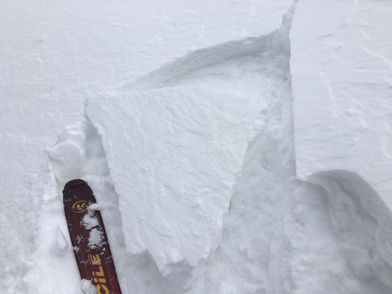
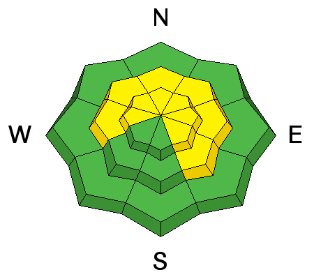
Strong southerly winds throughout the day yesterday and continuing overnight have strafed the snow surface, picked up snow, and deposited stiff, shallow wind slabs on the lee sides of every conceivable terrain feature. Yesterday I found them to be mostly isolated but expect them to become more connected and widespread throughout the day. Suspect any steep slope with smooth rounded deposits of wind drifted snow, and look for signs of instability such as cracking in the snow surface. Winds are also creating widespread cornices along ridgelines. Give them a wide berth when traveling along ridges and avoid travel beneath them.
Yesterday I was able to crack out isolated, shallow wind slabs such as this. Expect the problem to become more widespread today. |
| type | aspect/elevation | characteristics |
|---|

|
|
LIKELIHOOD
 LIKELY
UNLIKELY
SIZE
LARGE
SMALL
TREND
INCREASING DANGER
SAME
DECREASING DANGER
|
|
description
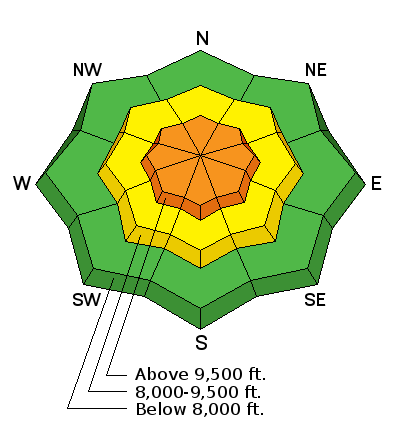
Avalanches breaking into old snow have been reported this past week. These include slides releasing on layers of faceted snow at the mid-pack, as well as down near the ground. Terrain where you are most likely to encounter this problem can be found above 9000' on aspects facing W-N-SE. Slopes that are most suspect include thinner snowpack areas outside of the upper Cottonwoods, as well as slopes that have already slid this season. Although we are not expecting the bulk of the snowfall with this upcoming storm to begin falling until tonight, drifts from the strong pre-frontal winds will add stress to these weak layers. |
 |
weather The front on the current storm system has stalled and is expected to reach our area later this evening. Today look for trace amounts of snow and continued strong southerly winds. Heavy snowfall should begin after 5:00 p.m with up to a foot of snow possible tonight and the same tomorrow. Check out this NWS video briefing on the upcoming event: |
| general announcements CLICK HERE FOR MORE GENERAL INFO AND FAQ The UAC has new support programs with Outdoor Research and Darn Tough. Support the UAC through your daily shopping. When you shop at Smith's, or online at Outdoor Research, REI, Backcountry.com, Darn Tough, Patagonia, NRS, Amazon, eBay a portion of your purchase will be donated to the FUAC. See our Donate Page for more details on how you can support the UAC when you shop. Benefit the Utah Avalanche Center when you buy or sell on eBay - set the Utah Avalanche Center as a favorite non-profit in your eBay account here and click on eBay gives when you buy or sell. You can choose to have your seller fees donated to the UAC, which doesn't cost you a penny This information does not apply to developed ski areas or highways where avalanche control is normally done. This advisory is from the U.S.D.A. Forest Service, which is solely responsible for its content. This advisory describes general avalanche conditions and local variations always occur. |