25th Annual Black Diamond Fall Fundraising Party
Thursday, September 13; 6:00-10:00 PM; Black Diamond Parking Lot
25th Annual Black Diamond Fall Fundraising Party
Thursday, September 13; 6:00-10:00 PM; Black Diamond Parking Lot
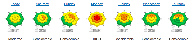
| Advisory: Salt Lake Area Mountains | Issued by Greg Gagne for Friday - February 23, 2018 - 4:30am |
|---|

|
bottom line A MODERATE hazard exists in isolated terrain on steep slopes facing north through east at the mid and upper elevations where human-triggered avalanches 1-3' failing in older snow are possible. Sluffing in loose storm snow is likely on steeper slopes. Although winds are forecasted to remain generally light, any increase in wind speeds will quickly create pockets of sensitive wind drifts at the upper elevations. The Good News: excellent and safer skiing and riding conditions can be found on many non-wind loaded southerly aspects, as well as lower-angled northerly slopes. Storms the past few weeks have finally provided many excellent options at the mid elevations for the first time this season.
|
 |
special announcement We have discount lift tickets for Alta, Snowbird, Brighton, Solitude, Snowbasin, and Beaver Mountain. Details and order information here. All proceeds from these go towards paying for avalanche forecasting and education! |
 |
current conditions Mountain temperatures are in the single digits, with a few of the warmer stations in the low teens. Winds are out of the south/southeast and generally light, averaging less than 10 mph with gusts in the teens at the upper elevations. 2-4" of snow has fallen in the Salt Lake mountains since Thursday afternoon. The Ogden mountains did quite well on Thursday with a sleeper system that left 7-14". Cold temperatures and generally cloudy weather this week has preserved excellent riding conditions on almost all aspects, with only a thin crust on southerly aspects. With snow expected today and again later on Saturday, be sure to check our Week in Review as you make your weekend plans:
|
 |
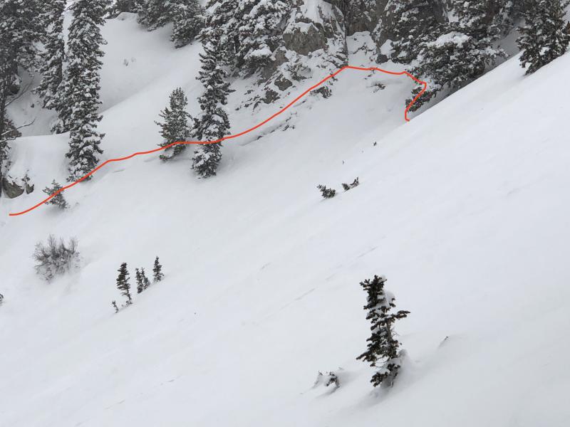
recent activity The only activity reported from Thursday included small pockets of sensitive fresh wind drifts on northerly aspects from south winds as well as sluffing in the top 2-4" of the weakening surface snow. In my field work on Thursday in Millcreek Canyon I came across two apparent natural avalanches that broke down into old snow, most likely running earlier this week. These were on northeast aspects at 9700', with starting zones in thin, rocky terrain.
The storm system this past Monday produced quite a few natural avalanches that failed in older, faceted snow. Details on these slides can be found HERE. |
| type | aspect/elevation | characteristics |
|---|

|
|
LIKELIHOOD
 LIKELY
UNLIKELY
SIZE
 LARGE
SMALL
TREND
 INCREASING DANGER
SAME
DECREASING DANGER
|
|
description
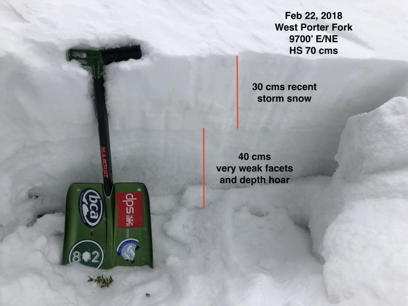
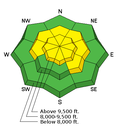
There is a MODERATE hazard in isolated terrain for triggering a persistent slab avalanche that could break down 1-3' into older snow. This isolated terrain is on north through east aspects above 9000', and includes: (1) Steep, rocky areas where there is a weak shallow snowpack as shown in the photo below.
It is easy to identify this snowpack structure by inverting your pole and jamming the handle down into the snow. If you can easily push through to the ground you have most likely found one of these thinner snowpack areas. (2) Repeater slopes where past avalanching has left a thin weak snowpack, such as this past Monday's slide on Davis Gulch on Gobblers Knob. The difficulty in assessing terrain is the spatial variability - the weak snowpack structure shown in the above pit was just around the corner where I was finding a strong and stable 1.5 meter (5') deep snowpack. Fortunately, this isolated terrain can easily be avoided as brilliant riding conditions can be found on almost all aspects at the mid and upper elevations. If you do choose to ride in steep northerly terrain, choose slopes with a clean runout that won't take you into trees or over rocks. |
| type | aspect/elevation | characteristics |
|---|

|
|
LIKELIHOOD
 LIKELY
UNLIKELY
SIZE
 LARGE
SMALL
TREND
 INCREASING DANGER
SAME
DECREASING DANGER
|
|
description
On Thursday I was finding the top 2-4" of the snow surface weak, and was easily getting sluffs to easily move on steeper terrain. I am expecting the snow at the existing surface to initially be the weakest layer with an additional load of storm snow and/or wind-loading, Any storm snow today will easily sluff on steeper slopes, especially those facing northwest through east where the existing snow surface is weakest. These sluffs will generally be small, but be aware of a sluff carrying you over rocks or accumuating in a steeper terrain trap. Ski cuts at the top of steeper slopes are an effective tool at mitigating this hazard. Although winds are forecasted to remain generally light, any increase in wind speeds will quickly create pockets of sensitive wind drifts at the upper elevations. Sluffing in the storm snow and any fresh wind drifts will also easily run on any slick crusts on southerly aspects. |
 |
weather With apologies to Henry James, we are in blissfully in the midst of the most beautiful words in the English language: cold, northwest flow. South winds will shift to the northwest early this afternoon, and should remain generally light, but gusts into the 20's mph at the upper elevations are possible. 4-8" of low-density snow is forecasted during the day, with the period of heaviest snowfall during the afternoon as the flow shifts to the northwest. Temperatures aren't expected to rise much today, lingering in the single digits and low teens. Snow showers and temperatures dipping below zero F overnight. Short break Saturday with a quick-hitting windier system expected later Saturday evening. |
| general announcements CLICK HERE FOR MORE GENERAL INFO AND FAQ The UAC has new support programs with Outdoor Research and Darn Tough. Support the UAC through your daily shopping. When you shop at Smith's, or online at Outdoor Research, REI, Backcountry.com, Darn Tough, Patagonia, NRS, Amazon, eBay a portion of your purchase will be donated to the FUAC. See our Donate Page for more details on how you can support the UAC when you shop. Benefit the Utah Avalanche Center when you buy or sell on eBay - set the Utah Avalanche Center as a favorite non-profit in your eBay account here and click on eBay gives when you buy or sell. You can choose to have your seller fees donated to the UAC, which doesn't cost you a penny This information does not apply to developed ski areas or highways where avalanche control is normally done. This advisory is from the U.S.D.A. Forest Service, which is solely responsible for its content. This advisory describes general avalanche conditions and local variations always occur. |