25th Annual Black Diamond Fall Fundraising Party
Thursday, September 13; 6:00-10:00 PM; Black Diamond Parking Lot
25th Annual Black Diamond Fall Fundraising Party
Thursday, September 13; 6:00-10:00 PM; Black Diamond Parking Lot
| Advisory: Salt Lake Area Mountains | Issued by Drew Hardesty for Thursday - February 22, 2018 - 5:13am |
|---|

|
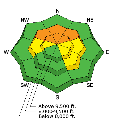
bottom line Areas of CONSIDERABLE danger remain in localized terrain on steep northwest to north to northeasterly facing slopes at the mid and upper elevations. Human triggered avalanches 1-3' deep are possible and may be triggered from below. Careful snowpack evaluation, cautious route-finding and conservative decision making remains essential today. If the southwest winds arrive ahead of schedule, watch for wind slab development in the higher elevations. The Good News: excellent and safer skiing and riding conditions can be found on many non-wind loaded southerly aspects. If headed to suspect terrain, the smart money stays on low angle slopes with no overhead hazard (ie-connected to steeper slopes above or adjacent to you).
|
 |
special announcement We have discount lift tickets for Alta, Snowbird, Brighton, Solitude, Snowbasin, and Beaver Mountain. Details and order information here. All proceeds from these go towards paying for avalanche forecasting and education! |
 |
current conditions Skies are partly cloudy. Ridgetop winds are blowing 10-15mph from the south-southwest. Not that you'd run out to grab your Hawaiian shirt, but mountain temps are above zero Fahrenheit this morning. Mostly. A few stations at 11,000' and down low where cold air sinks have the mercury on the wrong side of zero. Skiing and riding remain excellent, if a touch slow. After the last week's storm systems, many areas have pushed back to 60% of normal, whereas some of the stations in Ogden and Provo are at 40-50% (though Monte Cristo is at 75%) and 32%, respectively. Some - for the past number of years anyway - have been calling the Logan area mountains the new Alta of Utah . They sit at 85% of normal. |
 |
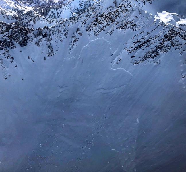
recent activity Ski area control work produced a few size 1 and 2 (see below) wind slabs, although nothing reportedly stepped down into old snow. One unintentional skier triggered wind pocket also released high on Superior a foot deep and 40' wide. On the other hand, yesterday's good visibility allowed observers to witness more evidence of the avalanche carnage from Monday's tipping point. Mineral Fork's Room of Doom (estimated 400' wide) - two pics below - and skier's left Wilson Chutes both went into old faceted snow. (Photos: Howie, Catano, White). As always, you can find place names and locations at wbskiing.com.
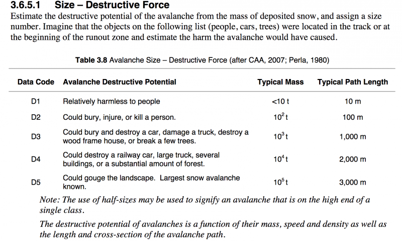
The snow, weather, and avalanche bible, affectionately known as SWAG (Snow,Weather, Avalanche Guidelines) provides a framework of methodology and language for snow professionals. The avalanche size scale - the destructive scale - is below. The entire SWAG pdf is here; otherwise the hardcopy (preferred) can be purchased online at the American Avalanche Association website.
|
| type | aspect/elevation | characteristics |
|---|

|
|
LIKELIHOOD
 LIKELY
UNLIKELY
SIZE
 LARGE
SMALL
TREND
 INCREASING DANGER
SAME
DECREASING DANGER
|
|
description
There's too much uncertainty. Let me point out a couple of examples here. Exhibit A: the Toots To Boot avalanche from Monday - A very experienced party skied on low thirty-degree terrain and it wasn't until the second person on the slope skied that it propagated back up and across the landscape to where the terrain reached the 44° steep headwall, pulling the whole thing down 300' wide. Standing just off to the side, the first skier watched the slide roar down, coming within 10' feet from where he was standing. Exhibit B: Note the photo above (in Recent Activity) of Wilson Chutes shoulder. The Wilson Chutes and apron remain intact as skiers center punch the line while the shoulder apparently had more snow and wind than it could handle. There is a great deal of spatial variability across the range. Those skiing and riding the steepest lines in the upper reaches of the Cottonwoods that take their game to the steep terrain of Mill Creek, Mt Aire and Lambs, the Sessions, areas along the PC ridgeline and the Wasatch back of Snake Creek, etc may not find things as, shall we say, forgiving. Similarly, snow tests in our suspect terrain elicits various and sometimes conflicting results. But it all has faceted snow and it has all seen significant wind and storm loading in the past week. Don't try to outsmart the avalanche. As the famed Swiss avalanche pioneer Andre Roch warned years ago, "The avalanche does not know that you are the expert." When presented with great uncertainty, one must allow for a greater margin for error. What does this mean?
|
 |
weather We'll see increasing clouds with the first of many generally weak weather systems on tap for northern Utah. For today, winds will be from the south and southwest at 10-15mph. Temps will be in the upper single digits up high,the mid to upper teens down low. We're expecting a number of quick moving systems over the next several days. Tonight into tomorrow may produce 3-6" with another quick hitter later Saturday and again on Monday. Temps again drop well below zero along the ridgelines on Saturday. And we thought winter was down for the count. It ain't how you start, it's how you finish. |
| general announcements CLICK HERE FOR MORE GENERAL INFO AND FAQ The UAC has new support programs with Outdoor Research and Darn Tough. Support the UAC through your daily shopping. When you shop at Smith's, or online at Outdoor Research, REI, Backcountry.com, Darn Tough, Patagonia, NRS, Amazon, eBay a portion of your purchase will be donated to the FUAC. See our Donate Page for more details on how you can support the UAC when you shop. Benefit the Utah Avalanche Center when you buy or sell on eBay - set the Utah Avalanche Center as a favorite non-profit in your eBay account here and click on eBay gives when you buy or sell. You can choose to have your seller fees donated to the UAC, which doesn't cost you a penny This information does not apply to developed ski areas or highways where avalanche control is normally done. This advisory is from the U.S.D.A. Forest Service, which is solely responsible for its content. This advisory describes general avalanche conditions and local variations always occur. |