25th Annual Black Diamond Fall Fundraising Party
Thursday, September 13; 6:00-10:00 PM; Black Diamond Parking Lot
25th Annual Black Diamond Fall Fundraising Party
Thursday, September 13; 6:00-10:00 PM; Black Diamond Parking Lot
| Advisory: Salt Lake Area Mountains | Issued by Evelyn Lees for Sunday - February 18, 2018 - 6:50am |
|---|


|
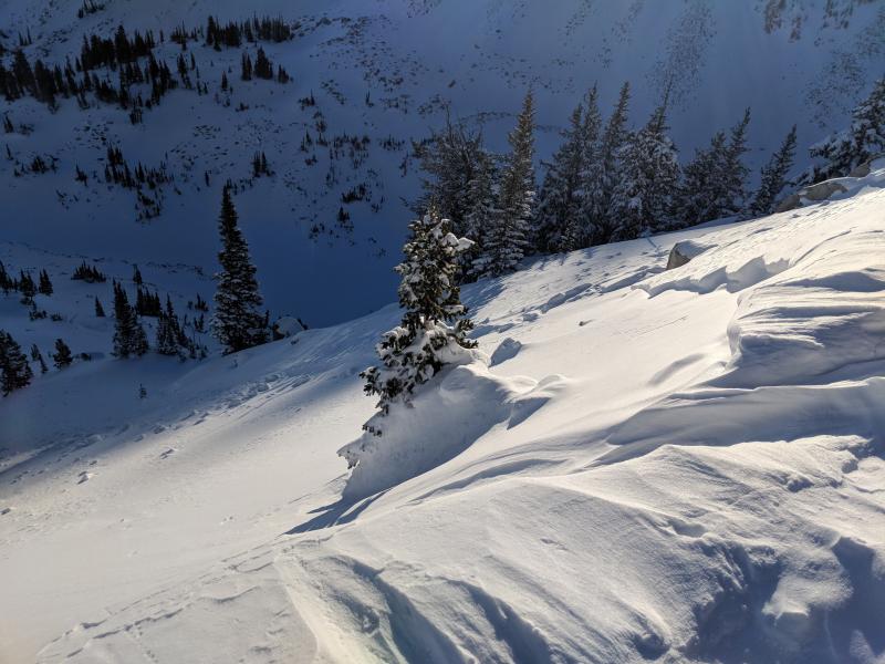
bottom line Increasing avalanche danger today through Monday in all the mountains of northern, central and southern Utah. The avalanche danger in the Salt Lake and Park City area mountains is CONSIDERABLE today on all steep, wind drifted slopes, and is expected to rise to HIGH overnight and Monday during periods of heavy snowfall. Dangerous avalanche conditions exist – avalanches can also break into the deeper weak layers on northwest through easterly facing slopes. If you head into the backcountry, careful snowpack evaluation, cautious route finding and conservative decision-making are essential.
|
 |
avalanche watch * TIMING…THROUGH 6 AM MST MONDAY * AFFECTED AREA…FOR THE ALL MOUNTAINS OF NORTHERN AND CENTRAL UTAH * AVALANCHE DANGER…THE AVALANCHE DANGER FOR THE WARNING AREA IS CONSIDERABLE AND IS EXPECTED TO RISE TO HIGH OVERNIGHT. * IMPACTS…STRONG WINDS TODAY WITH PERIODS OF HEAVY SNOW TONIGHT THROUGH TUESDAY WILL CREATE WIDESPREAD AREAS OF UNSTABLE SNOW. THE AVALANCHE DANGER WILL REMAIN ELEVATED THROUGH TUESDAY WITH BOTH HUMAN TRIGGERED AND NATURAL AVALANCHES BECOMING LIKELY. STAY OFF OF AND OUT FROM UNDER SLOPES STEEPER THAN 30 DEGREES. |
 |
special announcement We are saddened to report that Orem resident Alexander Marra was killed in an avalanche yesterday in Wyoming. He was skiing out-of-bounds at JHMR, and triggered a 2-foot deep slide that took him over cliffs. Our thoughts and sympathies go out to his family and friends. Accident Report. Episode 5 of the UAC podcast "To Hell in a Heartbeat - A Conversation With Tom Diegel and Matt Clevenger About the 12.26.08 Full Burial on Little Water" is live. Matt and Tom about the avalanche documented in To Hell in a Heartbeat. Check it out on ITunes, Stitcher, the UAC blog. Where are We Going? The Cottonwood Canyons are busy places with complex mixes of public and private land, and it can be confusing. This Blog illustrates just how confusing it can be and has a few resources to help you figure it all out. |
 |
current conditions After a calmer day than expected, the southwesterly winds finally picked up yesterday evening and have been blowing hard all night. The 9 and 10,000’ ridgelines have 25 mph averages with gusts in the 40s and 50s. At 11,000’, speeds are averaging 35 to 45 mph, with gusts to 70 mph. Skies are overcast, and mountain temperatures very warm this morning – in the mid 20s to mid 30s. |
 |
recent activity The only avalanche activity reported yesterday were small wind slabs, mostly confined to the upper elevations. Wolverine wind slab. Sean Burkhart photo.
With clearing skies, it was observed the Provo area mountains had a widespread avalanche cycle on Thursday. Thanks to Woody of UDOT for the great photos and info HERE. |
| type | aspect/elevation | characteristics |
|---|

|
|
LIKELIHOOD
 LIKELY
UNLIKELY
SIZE
 LARGE
SMALL
TREND
 INCREASING DANGER
SAME
DECREASING DANGER
|
|
description
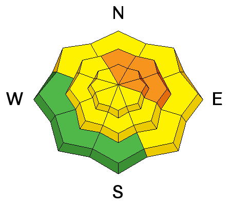
Wind drifts, known as wind slabs, will be much deeper and more widespread today and found at both the mid and upper elevations. Smooth, rounded, dense and cracky – they will be found along ridgelines and also well off the ridge lines, with drifts down in open bowls, along gully walls, and on mid slope break overs. Avoid wind drifts on steep slopes, which will be most widespread on the northerly through easterly facing slopes. Cornices will have formed along ridgelines, and often break back further than expected. Give them a wide berth. Natural avalanches are possible today - avoid traveling below steep wind drifted slopes. |
| type | aspect/elevation | characteristics |
|---|

|
|
LIKELIHOOD
 LIKELY
UNLIKELY
SIZE
 LARGE
SMALL
TREND
INCREASING DANGER
SAME
DECREASING DANGER
|
|
description
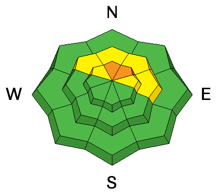
We are overloading the faceted weak layers in our snowpack with the additional weight of wind slabs today and new snow tonight. On many slopes, these previously dormant mid and lower pack weak layers will now be easier to trigger. As they become more sensitive, they can be triggered from a distance, from below or by releasing a wind slab that then steps down. Our snowpack depths are unusually variable, and the snowpack is especially weak where it is shallow, including slopes that have slid one or more times this year. Cracking and collapsing are bulls-eye clues to instability. |
 |
weather Another warm and windy day as we wait for the cold front to arrive. Increasing clouds all day. Temperatures will be in the upper 20s and 30s, and the southwesterly winds strong - with 30 to 40 mph averages at 9,000’ to 10,000’, and gusts in the 50s. The highest peaks will average to 45 mph, with gusts in the 60s and 70s. An intense frontal passage is expected around 4 pm in the Salt Lake and Park City area mountains, with a burst of heavy snowfall. Lightning is possible. About 3 to 5” of snow by sunset, with an additional foot or more of snow overnight. Winds will shift to the northwest and decrease, and temperatures plummet into the single digits. Very cold Monday and Tuesday, with additional snow possible, and storm totals by Tuesday could be in the 16 to 28” range. |
| general announcements CLICK HERE FOR MORE GENERAL INFO AND FAQ The UAC has new support programs with Outdoor Research and Darn Tough. Support the UAC through your daily shopping. When you shop at Smith's, or online at Outdoor Research, REI, Backcountry.com, Darn Tough, Patagonia, NRS, Amazon, eBay a portion of your purchase will be donated to the FUAC. See our Donate Page for more details on how you can support the UAC when you shop. Benefit the Utah Avalanche Center when you buy or sell on eBay - set the Utah Avalanche Center as a favorite non-profit in your eBay account here and click on eBay gives when you buy or sell. You can choose to have your seller fees donated to the UAC, which doesn't cost you a penny This information does not apply to developed ski areas or highways where avalanche control is normally done. This advisory is from the U.S.D.A. Forest Service, which is solely responsible for its content. This advisory describes general avalanche conditions and local variations always occur. |