25th Annual Black Diamond Fall Fundraising Party
Thursday, September 13; 6:00-10:00 PM; Black Diamond Parking Lot
25th Annual Black Diamond Fall Fundraising Party
Thursday, September 13; 6:00-10:00 PM; Black Diamond Parking Lot
| Advisory: Salt Lake Area Mountains | Issued by Mark Staples for Wednesday - January 24, 2018 - 5:41am |
|---|

|
bottom line Increasing southwest winds will create a wind slab problem today and potentially reactivate the persistent slab avalanche problem. Heightened avalanche conditions exist on any wind loaded slope and the avalanche danger is MODERATE on most mid and upper elevation slopes. Heads up - the danger could rise higher depending on how quickly winds increase and how much snow they are able to transport.
|
 |
special announcement Episode 3 of the UAC Podcast is live. UDOT Avalanche Program Supervisor, Bill Nalli, discusses how their team keeps the Greatest Snow on Earth from avalanching over the open roads and highways of the state. Check it out on ITunes, Stitcher, the UAC blog, or wherever you get your podcasts. |
 |
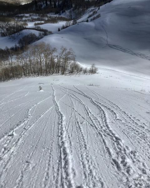
current conditions This morning mountain temperatures are in the upper teens F. Overnight winds shifted direction to the SW and were averaging 15 mph at ridgetops this morning with gusts of 20-25 mph. Snowfall from this weekend is still providing great riding conditions. Sunshine yesterday dampened the snow on slopes with a southerly aspect and these slopes should have a thin crust on them this morning. Photo below (M. White) shows evidence of dampening on a SE facing slope by the small, wet rollerballs of snow.
|
 |
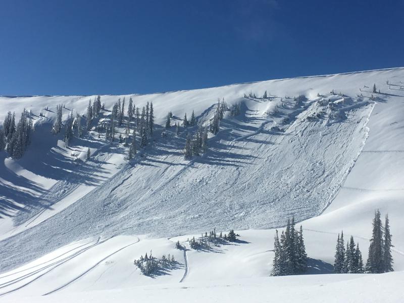
recent activity No avalanches were reported yesterday in the central Wasatch. However, 3 notable slides occurred on the northern slope of the Western Uinta Mountains. These were triggered low on the slope and perhaps foreshadow what is possible today if SW winds increase. Additionally, a skier in the Ogden area mountains triggered several wind drifts 2 days ago which also gives a clue of what is possible today with increased winds. Photo below of a significant avalanche triggered from the bottom of the slope in Upper Moffitt Basin in the Uinta Mountains.
|
| type | aspect/elevation | characteristics |
|---|

|
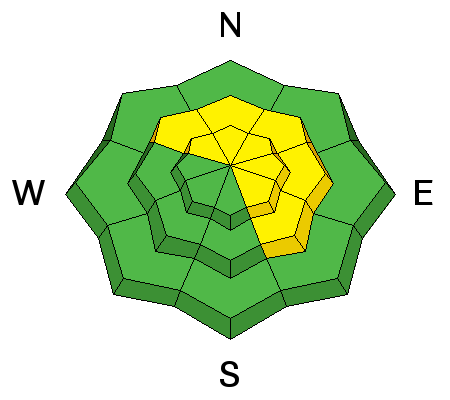
|
LIKELIHOOD
 LIKELY
UNLIKELY
SIZE
 LARGE
SMALL
TREND
 INCREASING DANGER
SAME
DECREASING DANGER
|
|
description
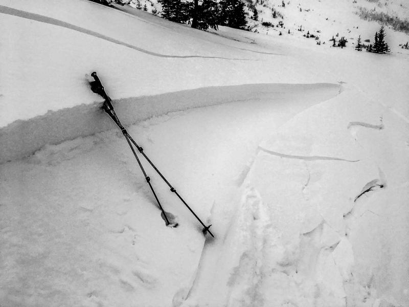
Watch for and avoid any slope today with evidence of wind loading or fresh wind slabs. These wind slabs may cause a larger avalanche breaking on weak, faceted snow buried 1-3 feet deep (see discussion below). Increasing SW winds today will have plenty of snow to transport from this weekend's storm and form fresh wind slabs. As winds increase today, wind slabs will grow in thickness and become easier to trigger. Two days ago, increased winds on Ben Lomond Peak in the Ogden area mountains formed fresh wind slabs that were easily triggered. Photo below (D. Wewer) shows one of these wind slabs and what can be expected today.
|
| type | aspect/elevation | characteristics |
|---|

|
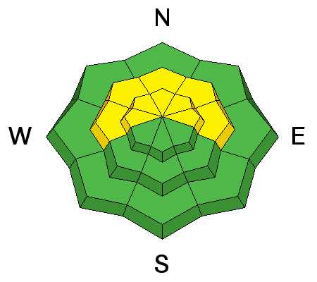
|
LIKELIHOOD
LIKELY
UNLIKELY
SIZE
LARGE
SMALL
TREND
INCREASING DANGER
SAME
DECREASING DANGER
|
|
description
Weak facets are easy to find when you step out of your skis, off your board, or off your machine because you'll sink to the ground. Most slopes have these facets, and yesterday lacked a load of new snow to cause widespread instability. Winds could change that today. I honestly don't know how much wind blown snow it will take to tip the scales and cause persistent slab avalanches today, BUT any amount of wind loading on a slope would be enough for me to avoid it. Previous persistent slab avalanches have broken 1-3 feet deep and several hundred feet wide. Generally speaking, southerly facing slopes lack the faceted snow causing this problem. Craig Gordon discusses Sunday's persistent slab avalanche in Snake Creek in the video below. Will this problem go away? The short answer is NO. Facets in the snowpack are here to stay. Time and warm temperatures will help faceted snow gradually gain some strength. HOWEVER, this process happens very very slowly, and every significant storm will potentially reactivate these weak facets. There's a very good chance that we'll see wet slab avalanches this spring when melting causes liquid water to percolate down to these facets. |
 |
weather Today will be mostly sunny with temperatures warming into the low 30's F. Southwest winds are the main story and will be steadily increasing today ahead of an approaching cold front. Winds should be the strongest tonight. At ridgetops winds should blow 20-30 mph with gusts in the 40's. The cold front will arrive tomorrow afternoon with snowfall continuing into tomorrow night. This much needed snowfall may only bring 3-5 inches. |
| general announcements CLICK HERE FOR MORE GENERAL INFO AND FAQ The UAC has new support programs with Outdoor Research and Darn Tough. Support the UAC through your daily shopping. When you shop at Smith's, or online at Outdoor Research, REI, Backcountry.com, Darn Tough, Patagonia, NRS, Amazon, eBay a portion of your purchase will be donated to the FUAC. See our Donate Page for more details on how you can support the UAC when you shop. Benefit the Utah Avalanche Center when you buy or sell on eBay - set the Utah Avalanche Center as a favorite non-profit in your eBay account here and click on eBay gives when you buy or sell. You can choose to have your seller fees donated to the UAC, which doesn't cost you a penny This information does not apply to developed ski areas or highways where avalanche control is normally done. This advisory is from the U.S.D.A. Forest Service, which is solely responsible for its content. This advisory describes general avalanche conditions and local variations always occur. |