25th Annual Black Diamond Fall Fundraising Party
Thursday, September 13; 6:00-10:00 PM; Black Diamond Parking Lot
25th Annual Black Diamond Fall Fundraising Party
Thursday, September 13; 6:00-10:00 PM; Black Diamond Parking Lot
| Advisory: Salt Lake Area Mountains | Issued by Greg Gagne for Friday - December 29, 2017 - 5:06am |
|---|

|
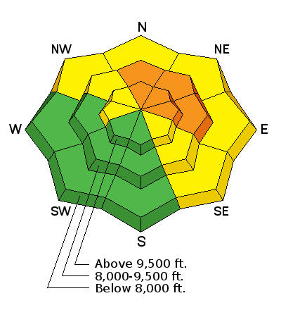
bottom line We have a CONSIDERABLE avalanche danger on mid and upper elevation slopes facing north through east for persistent slab avalanches that can fail in weak, sugary snow down near the ground. These slides may be large, and can be triggered remotely, including from lower-angled terrain below steeper slopes. Gusty westerly winds may create pockets of fresh wind drifts in open terrain.
|
 |
special announcement Alta Ski Area is now open in the Supreme area. Alta is performing avalanche work in this terrain. The area is closed to backcountry use. The Park City ski resort is doing control work in preparation for opening in McConkeys, Jupiter, McDonald Draw, Condor, Dreamscape and the Peak(Chutes) areas for the next several days These areas are closed to backcountry use. Brighton is now closed to uphill traffic through the New Year. Discount lift tickets for Alta, Snowbird, Brighton, Solitude, Deer Valley, Snowbasin,and Beaver Mountain are now available, donated by the resorts to benefit the Utah Avalanche Center. Details and order information here. All proceeds go towards paying for avalanche forecasting and education! |
 |
current conditions As of 5 am skies are clear with mountain temperatures in the mid-20s at some lower elevations where cooler air has pooled. Several stations between 9000' and 10,000' are in the mid and upper 30's. The westerly winds have continued to blow since Thursday, and are gusting into the 20's and 30's mph at the mid and upper elevations, and into the 40's at 11,000'. Currently our beaten-down snowpack holds about 1-3' of snow, and the strong sun and warm temperatures of the past few days have crusted many south and west aspects. You can still find dry settled snow on shady aspects, and the supportable surface makes for fun riding conditions, especially on lower-angled slopes. Week in Review (12/22 - 12/28) Friday December 22 was clear with increasing winds and clouds, ahead of a two-part storm system that would bring heavy snow and wind to the Wasatch mountains. Saturday December 23 involved increasing avalanche hazard with winds and storm snow overloading our weak snowpack. Storm totals in the Cottonwoods and along the Park City ridgeline were 12-18” with 1” of water. There were several remotely-triggered and natural avalanches reported during the day. Sunday December 24 included collapsing of the snowpack, and continued remote and natural avalanches. Monday December 25 The UAC issues an Avalanche Warning with continued snow and wind. 3-9” of dense snow is recorded overnight from the Provo to the Ogden mountains. These small totals were enough to finally tip the scales, with avalanches breaking down 12-24” into deeper, faceted layers near the ground. Tuesday December 26 The Avalanche Warning is extended. Storm totals since 12/22 in the Salt Lake, Park City, and Ogden mountains are 18-24”. Widespread natural and remotely-triggered slides were reported, and the recent storm snow has finally overloaded the weak layers in the base of the snowpack. Wednesday/Thursday December 27/28 - The storm track retreats to the north, leaving the Wasatch high and dry. But persistent weaknesses remain with both natural remotely-triggered avalanches reported. There were several close calls during this time, including professional ski patrollers performing snow safety, as well as four partial burials in the Ogden area mountains, see report below. Trent put together an excellent two minute piece below on current avalanche conditions. Or find it on YouTube. |
 |
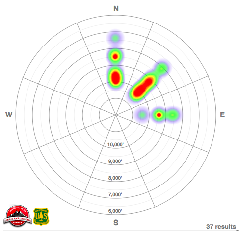
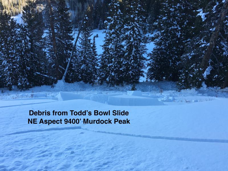
recent activity Field observers have continued to report collapsing in the snowpack, a sign that our persistent weak layer of facets found underneath the Christmas storm snow remains sensitive. Additionally, two avalanches were reported from Thursday, these were along the Park City ridgeline on steep northeast slopes at about 9500'. Both avalanches failed in facets, and at least one was remotely-triggered. Yesterday, Trent visited a natural avalanche that occured in a closed portion of Solitude Mountain Resort, and I visited a remotely-triggered slide that occurred on Murdock Peak along the Park City ridgeline. These two avalanches occurred on Wednesday, on northeast aspects between 9200' and 9500', each failing in faceted snow. You can find a list of all recent avalanches by clicking here. Below is a heatmap showing the distribution of recent avalanches (from Dec 23 through Dec 28) by aspect and elevation. This graphic nicely illustrates our ongoing concern with persistent slab avalanches on slopes facing north through east.
Mark Staples and USA (Utah Snowmobile Association) president Cal Taylor's excellent investigation of 4 partial burials in the Monte Cristo area (east of Huntsville) on Tuesday can be found here. (See video synopsis below). In brief, the riders triggered the 1/2 mile wide avalanche from below in this very close call. Interestingly, another party of UAC observers investigating the avalanche remotely triggered another, similar avalanche on an adjacent slope. |
| type | aspect/elevation | characteristics |
|---|

|
|
LIKELIHOOD
 LIKELY
UNLIKELY
SIZE
 LARGE
SMALL
TREND
 INCREASING DANGER
SAME
DECREASING DANGER
|
|
description
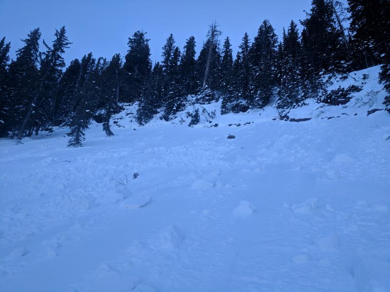
Continued reports of collapsing and reported avalanches from Thursday are a sure sign that our persistent slab problem remains a concern. Although I am expecting it will slowly become increasingly difficult to trigger avalanches, any avalanche you trigger is likely to be large and fail down near the ground. Highlights of persistent slab weaknesses include: - avalanches can be triggered remotely (from a distance) or from lower-angled terrain; - tracks on a slope are zero indication of stability. The slopes where you can find persistent slab weaknesses are mid and upper elevation aspects facing north through east, although even some steeper low-elevation shady slopes are suspect. And, although the odds of triggering a persistent slab avalanche are slowly reducing, rationalizing stability due to a small reduction in likelihood reminds me of advice my mentor Tom Kimbrough gives: It's like traveling in bear country and saying the grizzlies are a little less angry today. Despite the lack of snow, there is decent coverage in the mid and upper elevations where you can ride lower-angled slopes without exposing yourself to avalanche terrain greater than 30 degrees. The photos shown below are recent persistent slab avalanches:
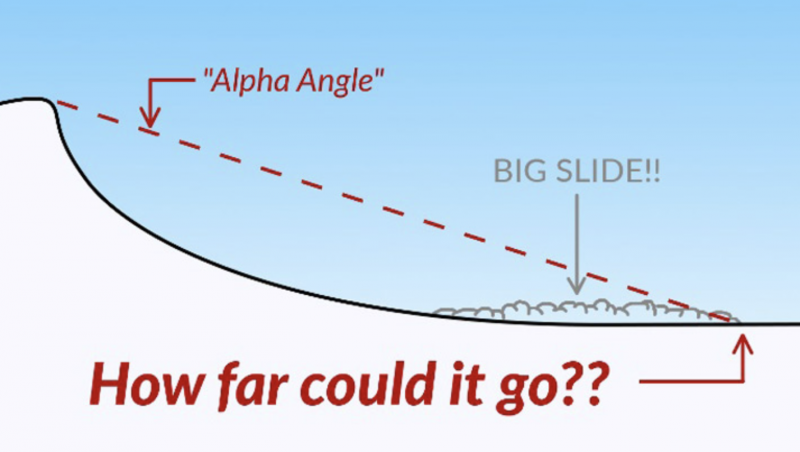
Hot Tip! - When natural activity is expected, when it's possible to trigger avalanches from below, or if people might trigger slides on top of you, you must understand runout angles. You can find a good article here. Also...Remember that 1/3 of bc tourers are caught while going uphill.
|
 |
weather For Friday, expect warm temperatures with occasional high clouds. Temperatures will rise into the low 40's at 8,000' and into the 30's at 10,000'. Westerly winds are expected to gust into the 30's, and 40's at the highest elevations, that will at least help make it feel cooler. Let's not even talk about the extended forecast. |
| general announcements FOR MORE GENERAL INFORMATION AND FAQ, CLICK HERE Support the UAC through your daily shopping. When you shop at Smith's, or online at REI, Backcountry.com, Patagonia, NRS, Amazon, eBay a portion of your purchase will be donated to the FUAC. See our Donate Page for more details on how you can support the UAC when you shop. Benefit the Utah Avalanche Center when you buy or sell on eBay - set the Utah Avalanche Center as a favorite non-profit in your eBay account here and click on eBay gives when you buy or sell. You can choose to have your seller fees donated to the UAC, which doesn't cost you a penny This information does not apply to developed ski areas or highways where avalanche control is normally done. This advisory is from the U.S.D.A. Forest Service, which is solely responsible for its content. This advisory describes general avalanche conditions and local variations always occur. |