25th Annual Black Diamond Fall Fundraising Party
Thursday, September 13; 6:00-10:00 PM; Black Diamond Parking Lot
25th Annual Black Diamond Fall Fundraising Party
Thursday, September 13; 6:00-10:00 PM; Black Diamond Parking Lot
| Advisory: Salt Lake Area Mountains | Issued by Greg Gagne for Friday - April 7, 2017 - 5:24am |
|---|

|
bottom line The avalanche hazard is LOW. However, small wet loose activity is possible, particularly if the sun comes out for extended periods or the winds diminish below forecasted levels. Small pockets of fresh drifts are possible in upper elevation terrain. Be sure to avoid traveling on or below large cornices.
|
 |
special announcement Who is up for some golf to benefit the Utah Avalanche Center? We have a donated gift certificate for four guest rounds and cart fees at Jeremy Ranch. We are asking $500 for this unique experience to golf for avalanche safety. See the certificate for conditions. Contact us if you are interested. |
 |
current conditions Warm and windy. Mountain temperatures range in the 30's and 40's F and southwest winds are cranking. Many mid and upper elevation stations are averaging in the 20's and 30's mph, with gusts into 40's and 50's mph. On Thursday I was finding dry snow on north aspects above about 10,000', although winds are likely to have deteriorated most of those surfaces by this morning. The winds and broken sky cover kept the snow surface cool yesterday, and I was finding east aspects to be softening by about 11 am. West aspects were softening perfectly when I was exiting at 1:30 in the afternoon. Week in Review [detailed version] On Thursday March 30 the central Wasatch received about 6" of storm snow. On Friday March 31, sun and greenhousing crusted all aspects and elevations, with the exception being northerly aspects above 10,500'. A round of significant wet activity occurred by mid-afternoon Friday as the snow surface warmed. Saturday brought a clear and warm day, and another round of loose, wet activity followed as the northeast winds began to relax. On Sunday, a weak storm system deposited 1-4" at the upper elevations. Monday through Thursday was highlighted by cool temperatures with solid refreezes. The avalanche hazard was Low, and other than minor wet loose activity, no avalanches were reported. During this period, recent storm snow on upper elevation north aspects became faceted and weakened. |
 |
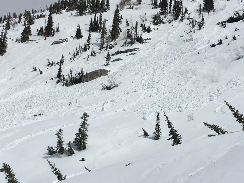
recent activity No observations were reported from the backcountry on Thursday, and with the exception of some minor loose, wet activity this week, we have had no reports of any avalanches since last Saturday. |
| type | aspect/elevation | characteristics |
|---|

|
|
LIKELIHOOD
 LIKELY
UNLIKELY
SIZE
 LARGE
SMALL
TREND
 INCREASING DANGER
SAME
DECREASING DANGER
|
|
description
The stable avalanche conditions this past week will continue for one more day. Although we have a Low avalanche hazard, you always need to pay attention when traveling in avalanche terrain. For today those concerns are:
We value any and all observations we receive. You can submit observations by visiting utahavalanchecenter.org |
 |
weather More clouds than sun today, with south/southwest winds gusting into the 40's and 50's mph. These strong winds will likely work down into mid elevation terrain. Mountain temperatures will rise into the 40's and mid 50's F. The southerly winds and warm temperatures signal the arrival of a decent-looking storm for this weekend which is currently forecasted to arrive in two pieces. The first piece arrives late tonight, with a rain/snow line at about 8500'. Minimal amounts of precipitation are forecasted with this initial piece. The second stronger wave arrives late in the day on Saturday, ushering in a colder unstable airmass that should keep convective snow showers going through much of the day on Sunday. By the time it clears out later on Sunday we may see 14-20" of new snow. |
| general announcements Remember your information can save lives. If you see anything we should know about, please help us out by submitting snow and avalanche conditions. You can also call us at 801-524-5304, email by clicking HERE, or include #utavy in your tweet or Instagram. To get help in an emergency (to request a rescue) in the Wasatch, call 911. Be prepared to give your GPS coordinates or the run name. Dispatchers have a copy of the Wasatch Backcountry Ski map. Backcountry Emergencies. It outlines your step-by-step method in the event of a winter backcountry incident. If you trigger an avalanche in the backcountry, but no one is hurt and you do not need assistance, please notify the nearest ski area dispatch to avoid a needless response by rescue teams. Thanks.
EMAIL ADVISORY If you would like to get the daily advisory by email you will need to subscribe here. DAWN PATROL Hotline updated daily by 5-530am - 888-999-4019 option 8. TWITTER Updates for your mobile phone - DETAILS UDOT canyon closures: LINK TO UDOT, or on Twitter, follow @UDOTavy, @CanyonAlerts or @AltaCentral Utah Avalanche Center mobile app - Get your advisory on your iPhone along with great navigation and rescue tools. Powderbird Helicopter Skiing - Blog/itinerary for the day Lost or Found something in the backcountry? - http://nolofo.com/ To those skinning uphill at resorts: it is critical to know the resort policy on uphill travel. You can see the uphill travel policy for each resort here. Benefit the Utah Avalanche Center when you shop from Backcountry.com or REI: Click this link for Backcountry.com or this link to REI, shop, and they will donate a percent of your purchase price to the UAC. Both offer free shipping (with some conditions) so this costs you nothing! Benefit the Utah Avalanche Center when you buy or sell on ebay - set the Utah Avalanche Center as a favorite non-profit in your ebay account here and click on ebay gives when you buy or sell. You can choose to have your seller fees donated to the UAC, which doesn't cost you a penny. This information does not apply to developed ski areas or highways where avalanche control is normally done. This advisory is from the U.S.D.A. Forest Service, which is solely responsible for its content. This advisory describes general avalanche conditions and local variations always occur |