25th Annual Black Diamond Fall Fundraising Party
Thursday, September 13; 6:00-10:00 PM; Black Diamond Parking Lot
25th Annual Black Diamond Fall Fundraising Party
Thursday, September 13; 6:00-10:00 PM; Black Diamond Parking Lot
| Advisory: Salt Lake Area Mountains | Issued by Greg Gagne for Friday - February 17, 2017 - 5:13am |
|---|

|
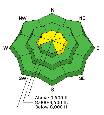
bottom line The avalanche danger is Moderate on slopes that are recently wind-loaded. This terrain includes west/north/east aspects at the upper elevations, and in open terrain in the mid elevations. Otherwise there is a mostly Low danger where the primary avalanche concern is loose sluffs on steeper northerly aspects.
|
 |
special announcement Companion piece to #NothingBadHappened called Hindsight 20/40. |
 |
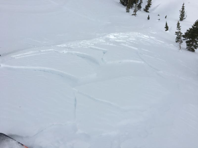
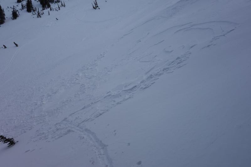
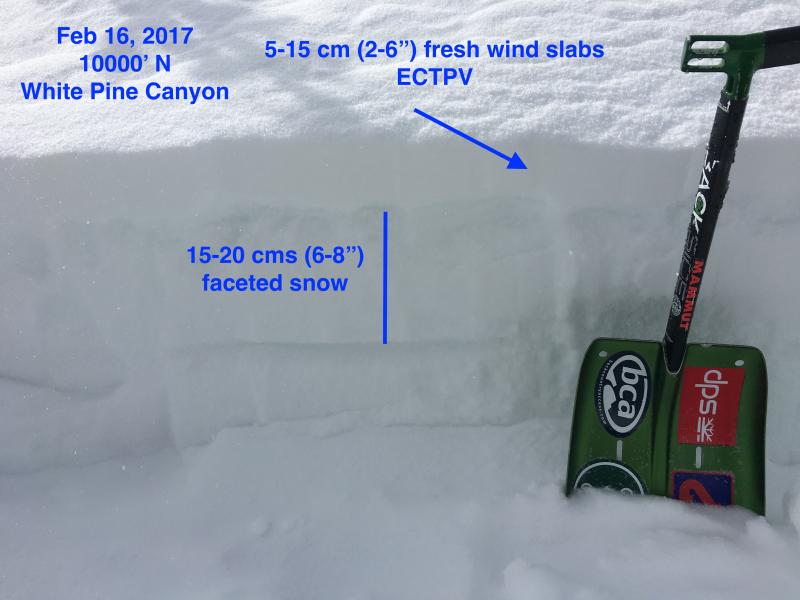
current conditions Winds from the south and west that blew in the moderate to strong category through much of the day yesterday in the mid and upper elevations have been gradually decreasing overnight, and are now generally light, with gusts in the teens at some mid elevations, and 20’s mph at upper elevations. Mountain temperatures range throughout the 20’s F. A trace to 1” of graupel fell late last evening. Week in Review Snowfall Friday and Saturday Feb 10/11 deposited 10-20" in the Salt Lake mountains with over 2" of water equivalent. Avalanche activity on Saturday included sensitive storm and wind slabs, as well as sluffing within the storm snow, with several human-triggered avalanches reported from the backcountry. Two notable natural avalanches in upper White Pine Canyon also occurred over the weekend. These were likely caused by natural cornice falls and triggered large storm slabs that failed on a layer of graupel down about 12-18". Fresh wind slabs from a period of easterly winds and continued sensitivity in the storm snow led to additional human-triggered activity on Sunday of mostly small to medium-sized avalanches. Sunday also marked the beginning of a period of warm high pressure with several loose wet avalanches on solar aspects earlier this week. Also the clear skies this past week has led to a considerable weakening of the snow surface where the top 2-6" has turned to weak faceted snow where there were several reports of sluffing on steeper northerly aspects. Observations from Thursday were finding fresh, sensitive wind slabs now sitting on top of the weaker faceted snow. |
 |
recent activity There were several reports from the backcountry on Thursday of sensitive wind drifts at the mid and upper elevations from the sustained moderate to strong winds. These drifts were not widespread and shallow, from 2-6", however they are sitting on top of weak faceted snow that formed earlier this past week. (Link - https://youtu.be/lxc2hZxeZ6Y)
|
| type | aspect/elevation | characteristics |
|---|

|
|
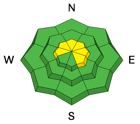
LIKELIHOOD
 LIKELY
UNLIKELY
SIZE
 LARGE
SMALL
TREND
 INCREASING DANGER
SAME
DECREASING DANGER
|
|
description
The primary avalanche concern for today are fresh drifts that formed during the day on Thursday. These drifts are sitting on top of weak, faceted snow and can be found on west, north, and east aspects, and although are mostly at the upper elevations, there were reports of drifts in open terrain as low as 9500'. This structure of a strong wind slab on top of weak facets will keep these wind drifts sensitive today. Increasing south winds are likely to create additional fresh slabs during the day.
Although any wind-drifted avalanches triggered today are not likely to be large, there was one report yesterday of a catch-and-carry in a relatively small slide. Fortunately this party used a safe travel protocol of traveling one at a time across an avalanche-prone slope. Be sure to consider the consequences of where you may end up if you get caught in one of these slides. |
| type | aspect/elevation | characteristics |
|---|

|
|
LIKELIHOOD
 LIKELY
UNLIKELY
SIZE
 LARGE
SMALL
TREND
 INCREASING DANGER
SAME
DECREASING DANGER
|
|
description
Normal Caution. Remember that risk is inherent in mountain travel. Additional avalanche concerns for the backcountry includes the following:
|
 |
weather It will remain mild with temperatures rising into the upper 30’s. Winds will be from the south, averaging about 20 mph with gusts over 40 mph at the upper elevations, and in the teens with gusts around 25 mph at the mid elevations. Winds are expected to become persistent and increase throughout the day. Periods of light snow are expected to develop with 1-3” possible by later in the afternoon. The rain/snow line may rise as high as 8000' Additional snowfall is expected overnight, with disorganized precipitation on a southwest flow for the day on Saturday. Favored locations may receive upwards of 6-12" by later Saturday evening. Sunday appears to be a decent snow producer as well. A brief ridge of high pressure for early in the week. And although I don't want to jinx us, models are advertising deep low pressure with a COLD storm on tap for later in the week. |
general announcements
|