| Please join us at the 23rd annual Black Diamond Fall Fundraiser Party Thursday Sept 15. Tickets are on sale now here, at the Black Diamond store & at REI. Special bonus raffle for online ticket purchasers! |
| Please join us at the 23rd annual Black Diamond Fall Fundraiser Party Thursday Sept 15. Tickets are on sale now here, at the Black Diamond store & at REI. Special bonus raffle for online ticket purchasers! |
| Advisory: Salt Lake Area Mountains | Issued by Mark Staples for Friday - April 15, 2016 - 4:46am |
|---|


|
bottom line A large wet slab avalanche was triggered yesterday in upper Little Cottonwood. Most avalanches occur within 24-48 hours of a storm, and today I'd give the snowpack time to adjust to the recent crazy weather which includes warm temperatures, rain, snow, cold temperatures, etc. More wet slab avalanches are possible.
|
 |
special announcement We will issue intermittent advisories through April as conditions warrant. We will continue to post observations as they are especially important to the backcountry community this time of year. If you see anything you feel we should know about, please submit an observation. |
 |
current conditions Since yesterday 6-8 inches of snow fell above 9000 feet with about 4 inches at 7000 feet. Much of this snow fell as dense graupel (hail-like pellets of snow) and was capped by a few inches of low density snow late yesterday afternoon with cooling temperatures. This morning temperatures dropped into the upper teens F at upper elevations and into the 20's F at lower elevations. Light winds are blowing 5 mph from the NW and some snow is falling. A combination of very warm temperatures and rain made the the snowpack very wet and unsupportable yesterday morning. Cold temperatures overnight likely helped to refreeze the old snow surface to some degree, but the new snow can act like a blanket and trap heat in the snowpack keeping it wet under the new snow. Several observers experienced collapsing yesterday (read the obs here). Today, it will be worth digging 1 foot deep where you will find wet snow, an ice crust, and graupel. Assess the bonding between these layers. A more dangerous issue is facets near the ground - WHAT?? (see Recent Activity below). This weak layer caused many avalanches in late December and early January, and continued producing repeated avalanches on N and NE facing slopes. It gained strength through the winter and was no longer a problem by March. However, recent warm weather weakened this layer again as it became damp. Is it a widespread problem? I don't know. Will there be more avalanches on this layer? i don't know. How likely is it to trigger avalanches on this layer? I don't know. There are a lot unanswered questions. |
 |
recent activity Yesterday in upper Little Cottonwood Canyon, a large wet slab avalanche was triggered with a small explosive. It broke on damp facets at the ground, 5.5 feet deep. It was 200 feet wide, ran 700 feet, and produced debris 15 feet deep. This avalanche occurred on a NNE aspect at 9900 feet. |
| type | aspect/elevation | characteristics |
|---|

|
|
LIKELIHOOD
 LIKELY
UNLIKELY
SIZE
 LARGE
SMALL
TREND
 INCREASING DANGER
SAME
DECREASING DANGER
|
|
description
Wet slabs are difficult to predict and difficult to trigger. They are also scary because they can be like an avalanche of concrete. Unfortunately we have only one data point - a big avalanche yesterday. This piece of data overrides any other information or "gut feeling". The bad new is that these facets remain damp and unaffected by cold temperatures because they are insulated by almost 6 feet of snow. The good news is that cold temperatures have stopped the weakening process and halted the flow of liquid water into the snowpack. The danger of this problem is decreasing, but warrants choosing conservative terrain for today especially on the northeastern quarter of the compass where facets at the ground were a problem for much of the winter. |
| type | aspect/elevation | characteristics |
|---|

|

|
LIKELIHOOD
LIKELY
UNLIKELY
SIZE
 LARGE
SMALL
TREND
 INCREASING DANGER
SAME
DECREASING DANGER
|
|
description
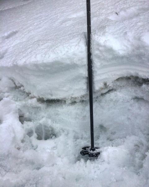
There are a few other concerns and I don't know how to label the avalanche problem. Within the upper foot of the snowpack, there is wet snow, ice crusts, graupel, and new snow. Fortunately, these layers are easy to assess with snowpack tests, ski cuts, and test slopes. The tricky part is that the strength/weakness of these layers may vary a lot with elevation and aspect. While it sounds complicated, it's not and just requires paying attention. Personally, I'd be more worried about the wet slab avalanche problem today. Photo showing wet snow under the new snow (M. White)
|
 |
weather More snow should fall today but only produce 2-3 inches of additional snow. Skies will remain cloudy and temperatures will warm into the upper 20s and near 30 degrees F at 9000 feet. Winds will remain mostly light today but will increase from the N by late this afternoon and blow 15-20 mph at ridgetops. On Saturday these stronger winds will continue and may increase a bit more. Overall, temperatures should remain cool through the weekend with mostly cloudy skies. |
general announcements
|