| Please join us at the 23rd annual Black Diamond Fall Fundraiser Party Thursday Sept 15. Tickets are on sale now here, at the Black Diamond store & at REI. Special bonus raffle for online ticket purchasers! |
| Please join us at the 23rd annual Black Diamond Fall Fundraiser Party Thursday Sept 15. Tickets are on sale now here, at the Black Diamond store & at REI. Special bonus raffle for online ticket purchasers! |
| Advisory: Salt Lake Area Mountains | Issued by Drew Hardesty for Saturday - February 20, 2016 - 6:08am |
|---|

|
bottom line Most terrain enjoys a LOW avalanche danger today. Isolated pockets of hard wind slab (accounting for the Moderate), however, may be susceptible to triggering on a wide variety of aspects and more likely at the upper elevations. These rounded pockets should be judged suspect, particularly if you're above terrain with ugly consequences. In the unlikely event the sun peeks through earlier than expected, the south and west facing steep terrain may bump toward Moderate for wet snow avalanches.
|
 |
special announcement Thursday 2/25 - Utah Adventure Journal presents adventure photographer Jim Harris at Snowbird's Wildflower Lounge. More Details Here. Couple new Blog posts:
|
 |
current conditions Like the old-timers in North Dakota tell me, "whenever the wind stops, all the cows fall over". Skies are mostly cloudy to overcast with a storm grazing by to the north and we'll see just a touch of precip this morning. Temperatures are in the upper 20s to low 30s. El Viento blows from the west southwest at 15-20mph with gusts to 35. Riding conditions are a patchwork of sun, wind, and rime crust with a few downed trees and pine needles thrown in for good measure. Wind (Mark White, Bill Brandt). Snow depths average 65-75-85" in Park City, Big, and Little Cottonwood, respectively at 9500' snowstakes and the SNOTEL sites report us as 90-100% of average for snow water equivalent for the year.
|
 |
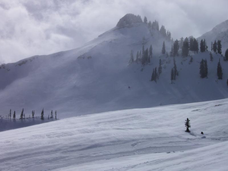
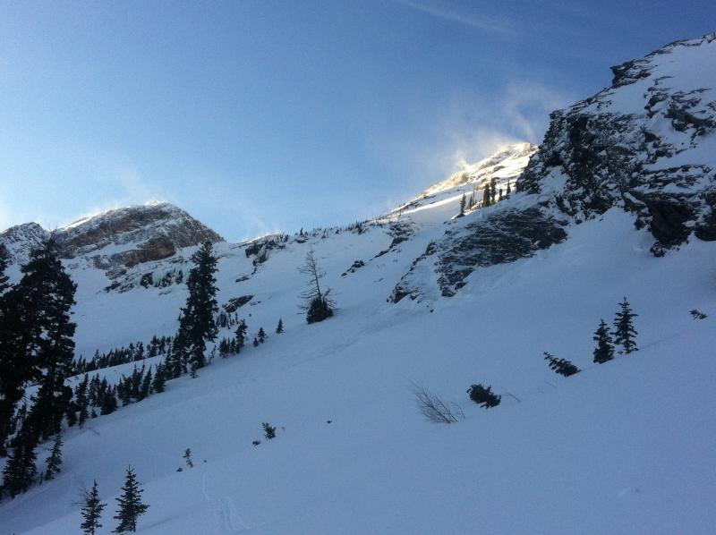
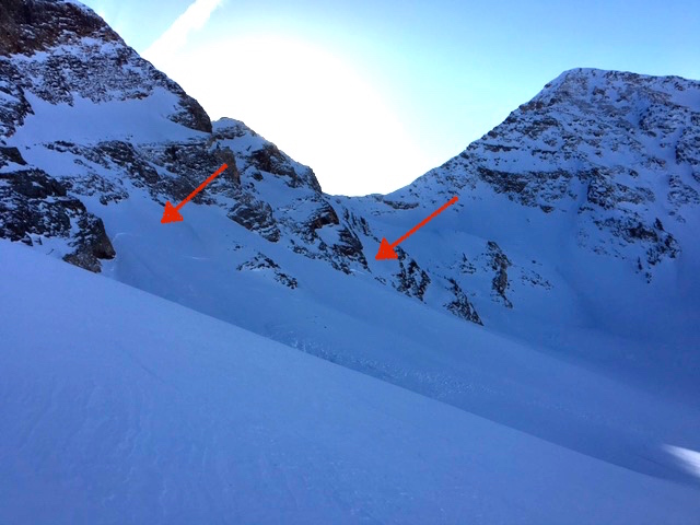
recent activity One touring party experienced a collapse in upper Broads Fork of BCC. Otherwise, avalanche activity noted only by snow safety teams at the mountain resorts in the way of wind slabs 8-12" deep. Actually, this is not true. A new (likely late Thursday night/early Friday) glide release 2-4' deep and 150' wide peeled off one of the lower rock slabs of mid-Broads just up canyon from Bonkers. (photos: Muller/Pugliese, Hardesty). Lower photo of natural wind slabs 1-2' deep in upper Broads from the same time period. (Hardesty)
|
| type | aspect/elevation | characteristics |
|---|

|
|
LIKELIHOOD
 LIKELY
UNLIKELY
SIZE
 LARGE
SMALL
TREND
 INCREASING DANGER
SAME
DECREASING DANGER
|
|
description
While the winds found their way into nearly every nook and cranny of the mountains, I wouldn't necessarily call it "optimal wind loading conditions". Strong, erratic, gusty winds tend to allow for patchwork and pockety drifts in odd locations rather than bread and butter sensitive wind drifts just off the ridge or sub-ridgelines. Some winds were even blowing upslope (see below). I suspect an avalanche hunter could find and trigger one of the smooth rounded pockets today, but these should be increasingly welded in and stubborn. Failure might take place in the pre-storm faceted snow at the old snow surface, 1cm lunar-lander shaped graupel with Thursday's midday frontal passage, or odd old snow interaces not unlike the one triggered in No Name from a couple days ago. I imagine No Name needs a rest.
|
 |
weather A grazing disturbance to the north will bring cloud cover and perhaps a trace to an inch of snow along the Idaho border. Accompanying winds will be west to northwest at 15-20mph; add 10mph to those averages north of I-80. Cooler temps will also filter in with the storm and ridgetop temps will be in the upper teens to low 20s; 8000' temps in the low 30s. We'll perhaps see some partial clearing this afternoon and overnight with partly cloudy skies on Sunday. Winds should be 10-15mph or less tomorrow. A weak system moves through Monday into Tuesday with benign weather through the rest of the week. |
| general announcements Remember your information can save lives. If you see anything we should know about, please participate in the creation of our own community avalanche advisory by submitting snow and avalanche conditions. You can also call us at 801-524-5304, email by clicking HERE, or include #utavy in your tweet or Instagram. To get help in an emergency (to launch a rescue) in the Wasatch, call 911. Be prepared to give your GPS coordinates or the run name. Dispatchers have a copy of the Wasatch Backcountry Ski map. Backcountry Emergencies. It outlines your step-by-step method in the event of a winter backcountry incident. If you trigger an avalanche in the backcountry, but no one is hurt and you do not need assistance, please notify the nearest ski area dispatch to avoid a needless response by rescue teams. Thanks. Salt Lake and Park City – Alta Central (801-742-2033), Canyons Resort/PCMR Dispatch (435)615-1911 Snowbasin Resort Dispatch (801-620-1017), Powder Mountain Dispatch (801-745-3772 x 123). Sundance Dispatch (801-223-4150) EMAIL ADVISORY If you would like to get the daily advisory by email you will need to subscribe here. DAWN PATROL Hotline updated daily by 5-530am - 888-999-4019 option 8. Twitter Updates for your mobile phone - DETAILS UDOT canyon closures: LINK TO UDOT, or on Twitter, follow @UDOTavy, @CanyonAlerts or @AltaCentral Utah Avalanche Center mobile app - Get your advisory on your iPhone along with great navigation and rescue tools. Powderbird Helicopter Skiing - Blog/itinerary for the day Lost or Found something in the backcountry? - http://nolofo.com/ To those skinning uphill at resorts: it is your responsibility to know the resort policy on uphill travel. You can see the uphill travel policy for each resort here. IMPORTANT: Before skinning or hiking at a resort under new snow conditions, check in with Ski Patrol. Resorts can restrict or cut off access if incompatible with control and grooming operations. Benefit the Utah Avalanche Center when you shop from Backcountry.com or REI: Click this link for Backcountry.com or this link to REI, shop, and they will donate a percent of your purchase price to the UAC. Both offer free shipping (with some conditions) so this costs you nothing! Benefit the Utah Avalanche Center when you buy or sell on ebay - set the Utah Avalanche Center as a favorite non-profit in your ebay account here and click on ebay gives when you buy or sell. You can choose to have your seller fees donated to the UAC, which doesn't cost you a penny. This information does not apply to developed ski areas or highways where avalanche control is normally done. This advisory is from the U.S.D.A. Forest Service, which is solely responsible for its content. This advisory describes general avalanche conditions and local variations always exist. |