| During the month of April, Mark Miller will donate $75 to the charity of your choice (5 to chose from, including the Utah Avalanche Center!) Mark Miller Subaru has raised over $300k in the previous 6 Do Good Feel Good events. More Info here |  |
| During the month of April, Mark Miller will donate $75 to the charity of your choice (5 to chose from, including the Utah Avalanche Center!) Mark Miller Subaru has raised over $300k in the previous 6 Do Good Feel Good events. More Info here | |
| Advisory: Salt Lake Area Mountains | Issued by Drew Hardesty for Thursday - March 26, 2015 - 5:51am |
|---|

|
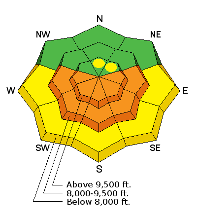
bottom line During the heat of the day, the danger will rise toward CONSIDERABLE for human triggered wet loose sluffs as the recent storm snow transitions from cold and dry to warm and wet. While wet loose avalanches tend to run at a slower pace than their dry counterparts, it's more difficult to get untangled from flowing wet avalanches before they set up like concrete in the deposition zone. Isolated pockets of lingering wind drifts may be found in the high alpine, more pronounced on north to easterly facing terrain.
|
 |
special announcement Today is the Day! If you value what non-profit organizations in Utah do for you, including the Utah Avalanche Center, please give some love back today. We have several donors that will match whatever you donate, making your donation worth twice as much. The organizations getting the most donors (just a $10 minimum!) will get cash bonuses from local contributing businesses. We just missed the podium and prizes last year and don't intend to get left out this year!
TONIGHT - Utah Adventure Journal - Snowbird Speaker Series: the topic will be The Essential Guide to Snowfall: The Where, When, and Why of Big Dumps, by Matt Jeglum, University of Utah Atmospheric Science PhD candidate with an emphasis in powder riding and splitboard mountaineering. Wildflower Lounge, 6 pm, 21+
|
 |
current conditions Skies are clear. Mountain temps are in the mid-20s, winds are northwesterly at 10-15mph with gusts to 25. Along the highest ridgelines, winds are blowing 20-25mph with gusts to 40. The sunny aspects will have breakable crust this morning while terrain up and over the ridge and into the northerly aspects will have something different altogether. 4-6" of settled small graupel and medium density powder rides best on low angle terrain and it wouldn't be much of a stretch to call it the best conditions of spring. |
 |
recent activity Stubbornly persistent northwesterly winds through yesterday morning led to a fair amount of drifting of the medium density snow in the upper elevations with ski area avalanche teams triggering 1-2' deep wind slabs with explosives and slope cuts in the upper Cottonwoods. Reactive drifts outside of the Cottonwoods were about half that size. By and large, these were more pockety than widespread and generally limited to the upper elevation east-to-northeast facing terrain just off the ridgelines. In the backcountry a skier descending from the top of Superior (11,050') into north facing Cardiac Bowl triggered and was caught and carried in a 12" deep and 50' wide wind pocket but came out unscathed. Another observer initiated a small dry loose sluff in steep northerly terrain off the Cottonwood ridgeline. |
| type | aspect/elevation | characteristics |
|---|

|
|
LIKELIHOOD
 LIKELY
UNLIKELY
SIZE
 LARGE
SMALL
TREND
 INCREASING DANGER
SAME
DECREASING DANGER
|
|
description
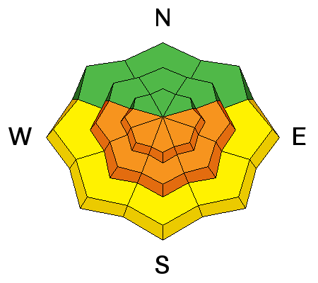
Wet avalanche activity, limited by cold temps, intermittent cloud cover and a slight northerly breeze, should be on full display today for folks overstaying their welcome on the steep sun-kissed terrain. Just like clockwork, wet activity will begin with solar heating first on east facing slopes, followed by south and then west. That window between cold breakable crust and wet and unstable cement will be a matter of a few hours. Human triggered wet sluffs in steep, confined terrain may produce sizeable - if tree-snapping debris piles in the runout zones below...and they may run further than expected on the hard, icy surface beneath them.Once you note roller balls of wet snow or natural wet sluffing, it's time to pack it up and move to cooler aspects or the trailhead. For more info on Travel Advice for Wet Loose Avalanches, click on the 'i' next to the Wet Loose infographic above. |
| type | aspect/elevation | characteristics |
|---|

|
|
LIKELIHOOD
 LIKELY
UNLIKELY
SIZE
LARGE
SMALL
TREND
 INCREASING DANGER
SAME
DECREASING DANGER
|
|
description
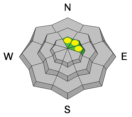
Worth a mention. While most of these wind drifts have likely settled out, continue to be suspicious of any wind pockets, particularly above steep unforgiving terrain. These are generally manageable with cornice drops and slope cuts, breaking at your feet or ride rather than above you (as is common with hard slabs or buried persistent weak layers). |
 |
weather High and dry. Temps will race toward the mid-30s at 10,000', the upper 40s at 8000'. Winds should lose steam and be light at most locations. Temps continue their upward march through the early part of the weekend, then cools as a storm races by to the north. The GFS and EC models have yet to work out their differences for next week - Stay tuned. |
| general announcements
Remember your information can save lives. If you see anything we should know about, please participate in the creation of our own community avalanche advisory by submitting snow and avalanche conditions. You can also call us at 801-524-5304, email by clicking HERE, or include #utavy in your tweet or Instagram. If you trigger an avalanche in the backcountry - especially if you are adjacent to a ski area – please call the following teams to alert them to the slide and whether anyone is missing or not. Rescue teams can be exposed to significant hazard when responding to avalanches, and do not want to do so when unneeded. Thanks. Salt Lake and Park City – Alta Central (801-742-2033), Canyons Resort Dispatch (435-615-3322) Snowbasin Resort Dispatch (801-620-1017), Powder Mountain Dispatch (801-745-3772 x 123). Sundance Dispatch (801-223-4150) EMAIL ADVISORY If you would like to get the daily advisory by email you will need to subscribe here. DAWN PATROL Hotline updated daily by 5-530am - 888-999-4019 option 8. Twitter Updates for your mobile phone - DETAILS UDOT canyon closures: LINK TO UDOT, or on Twitter, follow @UDOTavy, @CanyonAlerts or @AltaCentral Utah Avalanche Center mobile app - Get your advisory on your iPhone along with great navigation and rescue tools. Wasatch Powderbird Guides Blog/Itinerary for the Day. Lost or Found something in the backcountry? - http://nolofo.com/ Discount lift tickets are now available at Backcountry.com. Thanks to Ski Utah and the Utah Resorts. All proceeds go towards paying for Utah Avalanche Center avalanche and mountain weather advisories. To those skinning uphill at resorts: it is your responsibility to know the resort policy on uphill travel. You can see the uphill travel policy for each resort here. IMPORTANT: Before skinning or hiking at a resort under new snow conditions, check in with Ski Patrol. Resorts can restrict or cut off access if incompatible with control and grooming operations. Benefit the Utah Avalanche Center when you shop from Backcountry.com or REI: Click this link for Backcountry.com or this link to REI, shop, and they will donate a percent of your purchase price to the UAC. Both offer free shipping (with some conditions) so this costs you nothing! Benefit the Utah Avalanche Center when you buy or sell on ebay - set the Utah Avalanche Center as a favorite non-profit in your ebay account here and click on ebay gives when you buy or sell. You can choose to have your seller fees donated to the UAC, which doesn't cost you a penny. This information does not apply to developed ski areas or highways where avalanche control is normally done. This advisory is from the U.S.D.A. Forest Service, which is solely responsible for its content. This advisory describes general avalanche conditions and local variations always exist. |