| During the month of April, Mark Miller will donate $75 to the charity of your choice (5 to chose from, including the Utah Avalanche Center!) Mark Miller Subaru has raised over $300k in the previous 6 Do Good Feel Good events. More Info here |  |
| During the month of April, Mark Miller will donate $75 to the charity of your choice (5 to chose from, including the Utah Avalanche Center!) Mark Miller Subaru has raised over $300k in the previous 6 Do Good Feel Good events. More Info here | |
| Advisory: Salt Lake Area Mountains | Issued by Drew Hardesty for Wednesday - March 18, 2015 - 6:23am |
|---|

|
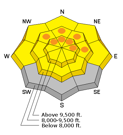
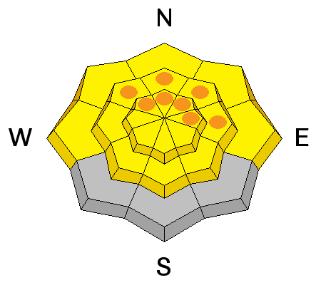
bottom line Areas of CONSIDERABLE danger exist in the mid and upper elevation northwest to east facing terrain for wet loose and wet slab avalanches. Unsupportable wet snow is a red flag. Remember it's more difficult to get untangled from flowing wet avalanches and they set up like concrete in the deposition zone. Elsewhere the danger is MODERATE.
|
 |
special announcement Tomorrow March 19 at 6 pm , Andrew McLean will present at the Wildflower Lounge at the Iron Blosam Lounge at the Snowbird Speaker Series about the Slotterhouse, an area in the Wrangell-St. Elias National Park in Alaska infested with steep couloirs, spectacular vistas, and endless mountaineering options. Free, with an optional raffle of great gear to benefit the Utah Avalanche Center. 21+ Thanks to the work of our Executive Director Paul Diegel and UAC educator/observer/video powerhouse Trent Meisenheimer, we secured status as part of Mark Miller Subaru's Do Good Feel Good fundraising for April 2015. Our 15 second clip below.
Pauls 15 second clip from Drew Hardesty on Vimeo.
|
 |
current conditions Skies are partly to mostly cloudy in the wake of the cold front that passed through overnight. No need to call in sick - I found one weather station in Ogden that registered .1" (that's point one inch of liquid precipitation. Temps along the ridgelines are on average 5-10* cooler than yesterday at this time, but many stations continue to be well north of freezing now for 72 to 96 hours or more. Winds have veered to the northwest and are blowing 10mph with gusts to 15. The snow was somewhat supportable on low angle southerly aspects yesterday, but one observer out and about said he ventured out of the backcountry to ski lifts at Alta around 130 pm. |
 |
recent activity Natural, explosive induced, and slope cut-induced wet loose and isolated pockets of wet slabs continued to run in steeper northerly terrain yesterday. Our forecaster Toby Weed in Logan put together a nice video that describes conditions well.
|
| type | aspect/elevation | characteristics |
|---|

|
|
LIKELIHOOD
 LIKELY
UNLIKELY
SIZE
 LARGE
SMALL
TREND
 INCREASING DANGER
SAME
DECREASING DANGER
|
|
description
It's a balancing act. On the plus side - Working in our favor are the slightly cooler temps. Same - to some degree - is the plumbing. Many snow study plots have lost 1-1.5" of water from the snowpack in the past 48 hours alone which indicates that melt-water is draining adequately in some places. This is an important point. Imagine a dump truck that just dumped a giant slurpee off the back, piling a 20' high cone in the yard. If you hosed it down with gallons of water, it would lose all its internal strength and slump over. Now imagine that instead that your water went straight into a vertical pipe which conveyed the water to the bottom and into the grass or into the street. On the other side - Cloud cover. Cloud cover at night prevents the snowpack from adequately cooling. The clouds are like a warm blanket, trapping the heat. If they trap the heat at night and dissipate during the day to allow for direct sun OR the thin clouds allow for greenhousing, it's a red flag. A structured snowpack. Water also tends to pool at interfaces within the snowpack - crusts and other density breaks - which explains some "siphoning" of the water at the old weak interfaces from mid-Feb and at the top of the old depth hoar. It's enough to make your head spin. But here's the catch - you're betting with your life. As my pal Nat Patridge with Exum mountain guides says, "If there's a question, then there is no question." My take-home - I'd avoid all steep west to north to southeast facing terrain today until cooler temps arrive to lock up the snowpack. Or anyplace you find yourself in unsupportable or collapsing snow.
|
 |
weather High pressure will again nose in today and we'll see clearing skies, light northerly winds, and temps in the mid-to upper 30s at 10,000', the mid to upper 40s at 10,000'. At least. A weak disturbance crosses by to the north over the weekend bringing some slightly cooler temps and one weather model depicts a "decent" (it's all relative these days) trof for late Monday through Wednesday. |
| general announcements
Remember your information can save lives. If you see anything we should know about, please participate in the creation of our own community avalanche advisory by submitting snow and avalanche conditions. You can also call us at 801-524-5304, email by clicking HERE, or include #utavy in your tweet or Instagram. If you trigger an avalanche in the backcountry - especially if you are adjacent to a ski area – please call the following teams to alert them to the slide and whether anyone is missing or not. Rescue teams can be exposed to significant hazard when responding to avalanches, and do not want to do so when unneeded. Thanks. Salt Lake and Park City – Alta Central (801-742-2033), Canyons Resort Dispatch (435-615-3322) Snowbasin Resort Dispatch (801-620-1017), Powder Mountain Dispatch (801-745-3772 x 123). Sundance Dispatch (801-223-4150) EMAIL ADVISORY If you would like to get the daily advisory by email you will need to subscribe here. DAWN PATROL Hotline updated daily by 5-530am - 888-999-4019 option 8. Twitter Updates for your mobile phone - DETAILS UDOT canyon closures: LINK TO UDOT, or on Twitter, follow @UDOTavy, @CanyonAlerts or @AltaCentral Utah Avalanche Center mobile app - Get your advisory on your iPhone along with great navigation and rescue tools. Wasatch Powderbird Guides Blog/Itinerary for the Day. Lost or Found something in the backcountry? - http://nolofo.com/ Discount lift tickets are now available at Backcountry.com. Thanks to Ski Utah and the Utah Resorts. All proceeds go towards paying for Utah Avalanche Center avalanche and mountain weather advisories. To those skinning uphill at resorts: it is your responsibility to know the resort policy on uphill travel. You can see the uphill travel policy for each resort here. IMPORTANT: Before skinning or hiking at a resort under new snow conditions, check in with Ski Patrol. Resorts can restrict or cut off access if incompatible with control and grooming operations. Benefit the Utah Avalanche Center when you shop from Backcountry.com or REI: Click this link for Backcountry.com or this link to REI, shop, and they will donate a percent of your purchase price to the UAC. Both offer free shipping (with some conditions) so this costs you nothing! Benefit the Utah Avalanche Center when you buy or sell on ebay - set the Utah Avalanche Center as a favorite non-profit in your ebay account here and click on ebay gives when you buy or sell. You can choose to have your seller fees donated to the UAC, which doesn't cost you a penny. This information does not apply to developed ski areas or highways where avalanche control is normally done. This advisory is from the U.S.D.A. Forest Service, which is solely responsible for its content. This advisory describes general avalanche conditions and local variations always exist. |