| During the month of April, Mark Miller will donate $75 to the charity of your choice (5 to chose from, including the Utah Avalanche Center!) Mark Miller Subaru has raised over $300k in the previous 6 Do Good Feel Good events. More Info here |  |
| During the month of April, Mark Miller will donate $75 to the charity of your choice (5 to chose from, including the Utah Avalanche Center!) Mark Miller Subaru has raised over $300k in the previous 6 Do Good Feel Good events. More Info here | |
| Advisory: Salt Lake Area Mountains | Issued by Bruce Tremper for Monday - March 16, 2015 - 6:07am |
|---|

|
bottom line The danger from wet avalanches is MODERATE on all aspects and elevations with pockets of CONSIDERABLE on the normally shady aspects (NW, N, NE and E) because the snow is getting wet for the first time.
|
 |
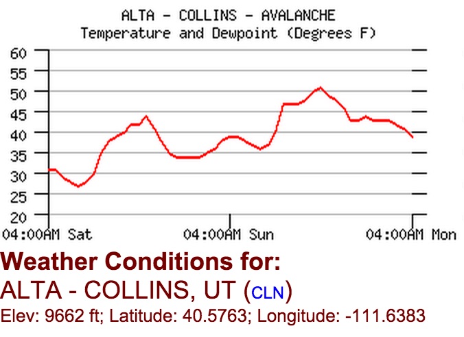
current conditions It's hot and balmy, like a summer night. Sunday's high was 51 degrees at 9,600' and 58 degrees at the base of Alta, which was 7 degrees warmer than on Saturday. At midnight last night, it was 9 degrees warmer than Saturday. Somewhat cooler air is arriving right now so the low this morning is about the same as Saturday. In Salt Lake City, we set an all time record yesterday for the warmest temperature on record for the date as well as a record for the low overnight. Yesterday, the mid level Stratus clouds were like a giant diffuser in the sky, which shined heat down on the traditionally shady, north facing slopes making them damp at most elevations. So there's no more dry snow left. The sunny aspects are wet and mushy and people are starting to punch through down to the ground, especially in the thinner snowpack areas. There was no refreeze last night.
This is a 2-day temperature for the Collins weather station at Alta.
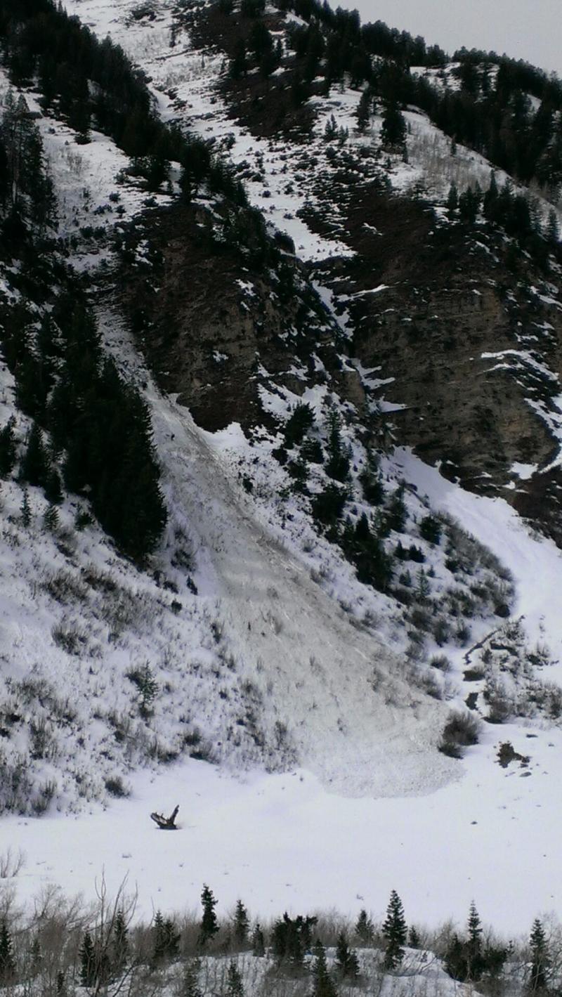
The south facing slopes even at upper elevations, like here above the town of Alta, are looking pretty moth-eaten. It usually looks like this in May. |
 |
recent activity The record warm temperatures caused increased wet sluffs and roller balls.
Wet activity in the Provo area mountains, east facing, 8,700' near Sundance. UDOT photo |
| type | aspect/elevation | characteristics |
|---|

|

|
LIKELIHOOD
 LIKELY
UNLIKELY
SIZE
 LARGE
SMALL
TREND
 INCREASING DANGER
SAME
DECREASING DANGER
|
|
description
Today will be the third day in a row without a good refreeze at night combined with very warm daytime temperatures. This means that on most aspects and elevations, water is strongly percolating through the snowpack and saturating buried layers. On the upper elevation, north and northeast facing slopes, the snow that was cold and dry on Saturday is getting wet for the first time. Just like people, snow gets cranky with rapid change. So expect fresh roller balls and damp sluffs especially on the traditionally shady slopes today. Deeper weak layers may get reactivated today.
Wet snow is notoriously hard to forecast. So today you should just stay off of, and out from underneath, steep slopes.
|
 |
weather We should have another unseasonably, hot, balmy day today with the daytime highs in the mid to upper 50's, variable, high clouds and a light to moderate breeze from the southwest. Somewhat cooler air is starting to push into Utah this morning so this should be on a slight cooling trend with colder temperatures on Wednesday when a very weak front pushes through. The extended forecast calls for a return to warm and sunny weather Thursday through the weekend. And you guessed it, no significant snow in the forecast. |
| general announcements Remember your information can save lives. If you see anything we should know about, please participate in the creation of our own community avalanche advisory by submitting snow and avalanche conditions. You can also call us at 801-524-5304, email by clicking HERE, or include #utavy in your tweet or Instagram. If you trigger an avalanche in the backcountry - especially if you are adjacent to a ski area – please call the following teams to alert them to the slide and whether anyone is missing or not. Rescue teams can be exposed to significant hazard when responding to avalanches, and do not want to do so when unneeded. Thanks. Salt Lake and Park City – Alta Central (801-742-2033), Canyons Resort Dispatch (435-615-3322) Snowbasin Resort Dispatch (801-620-1017), Powder Mountain Dispatch (801-745-3772 x 123). Sundance Dispatch (801-223-4150) EMAIL ADVISORY If you would like to get the daily advisory by email you will need to subscribe here. DAWN PATROL Hotline updated daily by 5-530am - 888-999-4019 option 8. Twitter Updates for your mobile phone - DETAILS UDOT canyon closures: LINK TO UDOT, or on Twitter, follow @UDOTavy, @CanyonAlerts or @AltaCentral Utah Avalanche Center mobile app - Get your advisory on your iPhone along with great navigation and rescue tools. Wasatch Powderbird Guides Blog/Itinerary for the Day. Lost or Found something in the backcountry? - http://nolofo.com/ Discount lift tickets are now available at Backcountry.com. Thanks to Ski Utah and the Utah Resorts. All proceeds go towards paying for Utah Avalanche Center avalanche and mountain weather advisories. To those skinning uphill at resorts: it is your responsibility to know the resort policy on uphill travel. You can see the uphill travel policy for each resort here. IMPORTANT: Before skinning or hiking at a resort under new snow conditions, check in with Ski Patrol. Resorts can restrict or cut off access if incompatible with control and grooming operations. Benefit the Utah Avalanche Center when you shop from Backcountry.com or REI: Click this link for Backcountry.com or this link to REI, shop, and they will donate a percent of your purchase price to the UAC. Both offer free shipping (with some conditions) so this costs you nothing! Benefit the Utah Avalanche Center when you buy or sell on ebay - set the Utah Avalanche Center as a favorite non-profit in your ebay account here and click on ebay gives when you buy or sell. You can choose to have your seller fees donated to the UAC, which doesn't cost you a penny. This information does not apply to developed ski areas or highways where avalanche control is normally done. This advisory is from the U.S.D.A. Forest Service, which is solely responsible for its content. This advisory describes general avalanche conditions and local variations always exist. |