| During the month of April, Mark Miller will donate $75 to the charity of your choice (5 to chose from, including the Utah Avalanche Center!) Mark Miller Subaru has raised over $300k in the previous 6 Do Good Feel Good events. More Info here |  |
| During the month of April, Mark Miller will donate $75 to the charity of your choice (5 to chose from, including the Utah Avalanche Center!) Mark Miller Subaru has raised over $300k in the previous 6 Do Good Feel Good events. More Info here | |
| Advisory: Salt Lake Area Mountains | Issued by Bruce Tremper for Monday - March 9, 2015 - 6:08am |
|---|

|
bottom line It's mostly LOW danger today with cautions for continued pockets of MODERATE danger for lingering persistent slabs in upper elevation, north through east facing slopes, especially in thin, rocky areas and also for wet sluffs in the heat of the day on steep, sun exposed slopes.
|
 |
special announcement Little Cottonwood Canyon will be closed this morning to sight in one of their howitzers for avalanche control. They should reopen around 8:15 am. |
 |
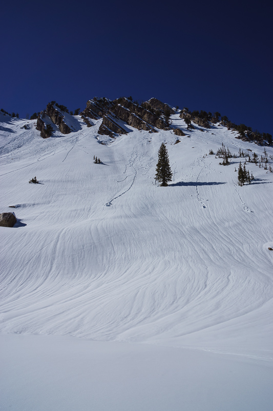
current conditions The snow has that old and worn out feel to it once again. All the sunny aspects have sun crusts and there's still some dense, 6-day-old powder--slightly recrystallized--on the upper elevation, shady aspects facing north and northeast. But most of it has a lot of tracks as well. Today should be yet another bluebird day in the mountains with light wind with temperatures in the upper 30's.
Not everything is tracked out... |
 |
recent activity The only slab triggered yesterday was by a slope cut by a WPG guide in the Sessions Mountains, which you can see on our Observations Page. |
| type | aspect/elevation | characteristics |
|---|

|
|
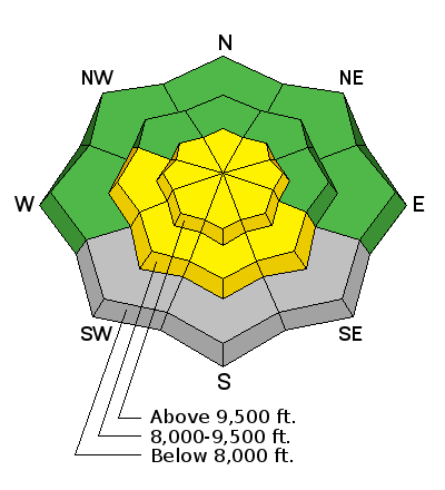
LIKELIHOOD
 LIKELY
UNLIKELY
SIZE
 LARGE
SMALL
TREND
 INCREASING DANGER
SAME
DECREASING DANGER
|
|
description
The danger from triggering a persistent slab has slowly decreased in the 6 days since the last storm. Most of our snow profile tests lately have shown no propagation on the buried layer of near-surface faceted snow buried 1-2 feet deep but we're occasionally getting tests that do show propagation. So it's still possible for someone to pop out a slab as we saw with the one triggered yesterday. But for the most part, many slopes are tracked up without incident lately. |
| type | aspect/elevation | characteristics |
|---|

|

|
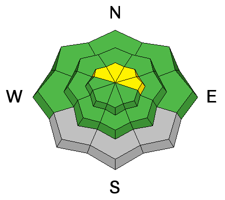
LIKELIHOOD
LIKELY
UNLIKELY
SIZE
LARGE
SMALL
TREND
 INCREASING DANGER
SAME
DECREASING DANGER
|
|
description
Likewise, most of the wet activity has significantly calmed down since the very warm day on Friday. But it's still possible to get wet sluffs going on the steep, sun exposed slopes, especially around rocks that heat up in the sun. Don't let one of these sluffs catch you in high consequence terrain. As usual, get off of, and out from underneath, steep, sun exposed slopes when they get wet from sun heating.
Here's a photo from my field day in the upper Mill A Basin yesterday showing the east aspect of Mt. Raymond. The vertical channels are called "rill marks" or "drainage channels." They form within new snow after melt water has percolated through it to form drainage channels under the new snow. They are actually a sign of stability since they indicate that the plumbing has been established and melt water will not likely pool up to create wet slabs. |
 |
weather Yet another day of perfect weather in paradise. Bluebird day with highs in the mid 30's at 9,000'. Wind should continue to be light. We should have slightly warmer temperatures on Tuesday. For the extended forecast, we should get a weak shot of snow on Thursday into Friday, which probably won't add up to much more than a couple inches. Then we continue to be stuck in the same high pressure ridge that has given us the driest, warmest winter on record, so far. If you're interested, HERE is the National Weather Service briefing on the the "meteorological winter" (December-January-February) for a discussion of the record warm and dry winter. |
| general announcements Remember your information can save lives. If you see anything we should know about, please participate in the creation of our own community avalanche advisory by submitting snow and avalanche conditions. You can also call us at 801-524-5304, email by clicking HERE, or include #utavy in your tweet or Instagram. If you trigger an avalanche in the backcountry - especially if you are adjacent to a ski area – please call the following teams to alert them to the slide and whether anyone is missing or not. Rescue teams can be exposed to significant hazard when responding to avalanches, and do not want to do so when unneeded. Thanks. Salt Lake and Park City – Alta Central (801-742-2033), Canyons Resort Dispatch (435-615-3322) Snowbasin Resort Dispatch (801-620-1017), Powder Mountain Dispatch (801-745-3772 x 123). Sundance Dispatch (801-223-4150) EMAIL ADVISORY If you would like to get the daily advisory by email you will need to subscribe here. DAWN PATROL Hotline updated daily by 5-530am - 888-999-4019 option 8. Twitter Updates for your mobile phone - DETAILS UDOT canyon closures: LINK TO UDOT, or on Twitter, follow @UDOTavy, @CanyonAlerts or @AltaCentral Utah Avalanche Center mobile app - Get your advisory on your iPhone along with great navigation and rescue tools. Wasatch Powderbird Guides Blog/Itinerary for the Day. Lost or Found something in the backcountry? - http://nolofo.com/ Discount lift tickets are now available at Backcountry.com. Thanks to Ski Utah and the Utah Resorts. All proceeds go towards paying for Utah Avalanche Center avalanche and mountain weather advisories. To those skinning uphill at resorts: it is your responsibility to know the resort policy on uphill travel. You can see the uphill travel policy for each resort here. IMPORTANT: Before skinning or hiking at a resort under new snow conditions, check in with Ski Patrol. Resorts can restrict or cut off access if incompatible with control and grooming operations. Benefit the Utah Avalanche Center when you shop from Backcountry.com or REI: Click this link for Backcountry.com or this link to REI, shop, and they will donate a percent of your purchase price to the UAC. Both offer free shipping (with some conditions) so this costs you nothing! Benefit the Utah Avalanche Center when you buy or sell on ebay - set the Utah Avalanche Center as a favorite non-profit in your ebay account here and click on ebay gives when you buy or sell. You can choose to have your seller fees donated to the UAC, which doesn't cost you a penny. This information does not apply to developed ski areas or highways where avalanche control is normally done. This advisory is from the U.S.D.A. Forest Service, which is solely responsible for its content. This advisory describes general avalanche conditions and local variations always exist. |