| During the month of April, Mark Miller will donate $75 to the charity of your choice (5 to chose from, including the Utah Avalanche Center!) Mark Miller Subaru has raised over $300k in the previous 6 Do Good Feel Good events. More Info here |  |
| During the month of April, Mark Miller will donate $75 to the charity of your choice (5 to chose from, including the Utah Avalanche Center!) Mark Miller Subaru has raised over $300k in the previous 6 Do Good Feel Good events. More Info here | |
| Advisory: Salt Lake Area Mountains | Issued by Brett Kobernik for Sunday - March 8, 2015 - 6:10am |
|---|

|
bottom line There is an overall MODERATE avalanche danger today. Human triggered avalanches are possible. Most likely places are steep north facing terrain above 9000 feet with shallow depths where the underlying snow remains weak. Watch for wet activity with daytime heating.
|
 |
current conditions Surface conditions took a hit from the heat on Saturday with most slopes becoming damp aside from the steeper high elevation north aspects. Lots of rollerballs noted on slopes that warmed for the first time yesterday. If things cooperate, we could see some decent corn soon. Temperatures overnight remained fairly warm with ridgetop readings in the upper 20s and low 30s. Winds are fairly light from the northwest. Skies are clear. |
 |
recent activity There was some wet acitivity reported from Saturday, most of it minor. One note from the Wasatch Powderbird Guides (thanks guys!) included a wet loose avalanche which did pop out a slab as it descended a southeast facing slope in the Provo region.
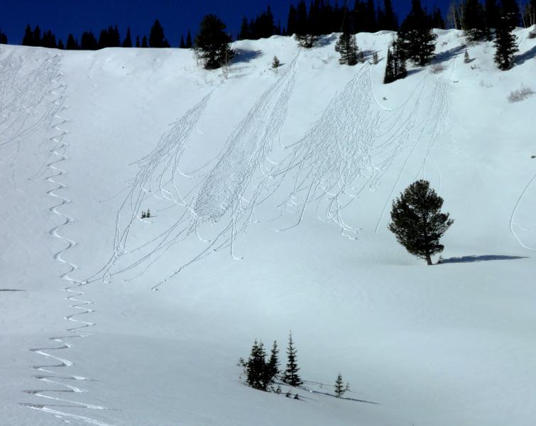
Lots of rollerballs and some wet loose slides, east and southeast facing aspect. Photo - Mark White |
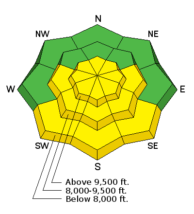
| type | aspect/elevation | characteristics |
|---|

|
|
LIKELIHOOD
 LIKELY
UNLIKELY
SIZE
 LARGE
SMALL
TREND
 INCREASING DANGER
SAME
DECREASING DANGER
|
|
description
The older weak snow is adjusting to the new load of snow from last week. Propagation tests are not yielding significant results but people are still noting lots of weak snow especially in the shallower areas. Chances for triggering something that breaks into old snow are becoming less likely but I wouldn't let my guard down.
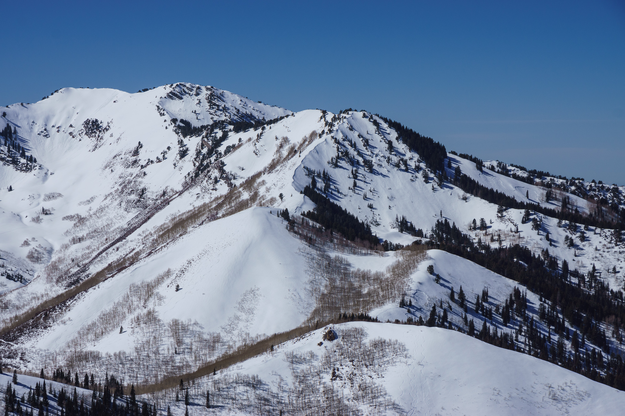
Looking west from Little Water Peak you can see recent avalanches in Soldier, Wilson Fork, and Wilson Glade. This type of terrain is where you might still find trouble as it has a relatively shallow and weak snowpack. Photo - Bruce Tremper |
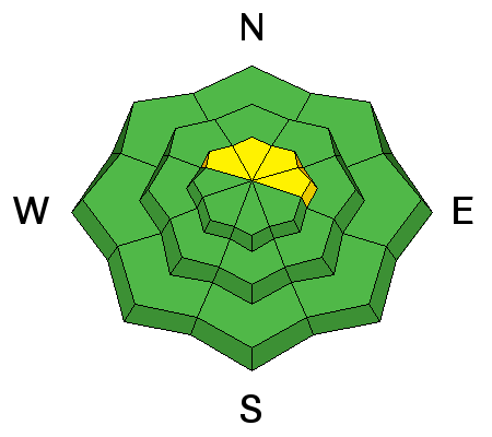
| type | aspect/elevation | characteristics |
|---|

|
|
LIKELIHOOD
LIKELY
UNLIKELY
SIZE
LARGE
SMALL
TREND
 INCREASING DANGER
SAME
DECREASING DANGER
|
|
description
After a number of melt-freeze cycles the last few days and with slightly cooler temperatures today, I don't expect wet activity to be more pronounced than on Saturday. It should be less. That said, pay attention!!! |
 |
weather High temperatures today should be slightly cooler than Saturday but we'll still see ridgetop highs in the mid 30s. We'll have mostly clear skies and light northwest wind. Monday looks similar then slightly warmer Tuesday and warmer yet Wednesday. We'll see a minor disturbance move through Wednesday into Thursday with slight chance for snow then the ridge moves back in and temperatures warm again into the weekend. |
| general announcements Remember your information can save lives. If you see anything we should know about, please participate in the creation of our own community avalanche advisory by submitting snow and avalanche conditions. You can also call us at 801-524-5304, email by clicking HERE, or include #utavy in your tweet or Instagram. If you trigger an avalanche in the backcountry - especially if you are adjacent to a ski area – please call the following teams to alert them to the slide and whether anyone is missing or not. Rescue teams can be exposed to significant hazard when responding to avalanches, and do not want to do so when unneeded. Thanks. Salt Lake and Park City – Alta Central (801-742-2033), Canyons Resort Dispatch (435-615-3322) Snowbasin Resort Dispatch (801-620-1017), Powder Mountain Dispatch (801-745-3772 x 123). Sundance Dispatch (801-223-4150) EMAIL ADVISORY If you would like to get the daily advisory by email you will need to subscribe here. DAWN PATROL Hotline updated daily by 5-530am - 888-999-4019 option 8. Twitter Updates for your mobile phone - DETAILS UDOT canyon closures: LINK TO UDOT, or on Twitter, follow @UDOTavy, @CanyonAlerts or @AltaCentral Utah Avalanche Center mobile app - Get your advisory on your iPhone along with great navigation and rescue tools. Wasatch Powderbird Guides Blog/Itinerary for the Day. Lost or Found something in the backcountry? - http://nolofo.com/ Discount lift tickets are now available at Backcountry.com. Thanks to Ski Utah and the Utah Resorts. All proceeds go towards paying for Utah Avalanche Center avalanche and mountain weather advisories. To those skinning uphill at resorts: it is your responsibility to know the resort policy on uphill travel. You can see the uphill travel policy for each resort here. IMPORTANT: Before skinning or hiking at a resort under new snow conditions, check in with Ski Patrol. Resorts can restrict or cut off access if incompatible with control and grooming operations. Benefit the Utah Avalanche Center when you shop from Backcountry.com or REI: Click this link for Backcountry.com or this link to REI, shop, and they will donate a percent of your purchase price to the UAC. Both offer free shipping (with some conditions) so this costs you nothing! Benefit the Utah Avalanche Center when you buy or sell on ebay - set the Utah Avalanche Center as a favorite non-profit in your ebay account here and click on ebay gives when you buy or sell. You can choose to have your seller fees donated to the UAC, which doesn't cost you a penny. This information does not apply to developed ski areas or highways where avalanche control is normally done. This advisory is from the U.S.D.A. Forest Service, which is solely responsible for its content. This advisory describes general avalanche conditions and local variations always exist. |