
| During the month of April, Mark Miller will donate $75 to the charity of your choice (5 to chose from, including the Utah Avalanche Center!) Mark Miller Subaru has raised over $300k in the previous 6 Do Good Feel Good events. More Info here |  |
| During the month of April, Mark Miller will donate $75 to the charity of your choice (5 to chose from, including the Utah Avalanche Center!) Mark Miller Subaru has raised over $300k in the previous 6 Do Good Feel Good events. More Info here | |
| Advisory: Salt Lake Area Mountains | Issued by Evelyn Lees for Tuesday - March 3, 2015 - 6:51am |
|---|

|
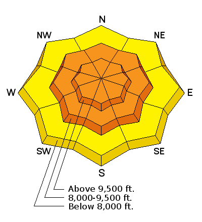
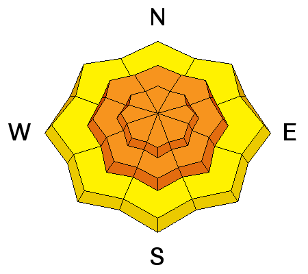
bottom line The avalanche danger is CONSIDERABLE on all slopes approaching 35 degrees and steeper. Human triggered avalanche are likely. Natural avalanches are possible, especially during periods of intense snowfall and wind. New snow soft slabs and sluffs will be widespread, and a few slides on the more northerly facing slopes may step down into a deeper weak layer, resulting in a large dangerous slide. Avoid travel on and below steep slopes today.
|
 |
special announcement The Avalanche Warning continues for mountains of southwest Utah, where the snow pack will be slow to stabilize. Backcountry Film Festival at Brewvies, Wednesday, March 4 at 7:00pm: Join us for an evening of nine unique films aimed to inspire winter adventurers to seek the snow less traveledand a killer raffle all while raising funds for the winter human powered experience. This is a benefit for Wasatch Backcountry Alliance and the Utah Avalanche Center *Brewvies is 21+. DETAILS HERE Utah Adventure Journal Snowbird Speaker Series, 6pm Mar 5 at the Wildflower Lounge: The Utah Avalanche Center will be joining the Utah Adventure Journal and friends of Jim Harris, photographer, writer, artist, avalanche observer and instructor in an evening of photos and presentations from Andrew McLean, Kalen Thorien, Noah Howell, Forest McCarthy, and Brendan Leonard. All proceeds will go towards helping to cover Jim's medical & rehab expenses following a kiting accident in Chile. Join us at Brighton Mar 7 & 8 for Vertfest! Clinics include Companion Rescue, Terrain Selection, Steep Skiing, and Mountaineering for skiers/split-boarders, both open and women-only. There will also be gear demos and the Wasatch Powder Keg ski mountaineering race, all to benefit the Utah Avalanche Center. More info here. |
 |
current conditions The final piece of a multipart storm will cross northern Utah this morning. It is already snowing in the mountains, and the cold front should arrive by late morning. 24-hour storm totals are around a foot in the Park City, Provo and Salt Lake area mountains, and about 9 inches in the Ogden area mountains. Temperatures are in the teens and 20s, with only a few single digit readings on the highest peaks. The winds are still from the west to southwest, averaging 10 to 15 mph, with gusts in the 20s. |
 |
recent activity Yesterday, both loose snow sluffs and a few soft slabs were triggered on steep slopes, of all new snow, and many were running fast and far. Small natural sluffs occurred during periods of heavier snow and wind. |
| type | aspect/elevation | characteristics |
|---|

|
|
LIKELIHOOD
 LIKELY
UNLIKELY
SIZE
 LARGE
SMALL
TREND
 INCREASING DANGER
SAME
DECREASING DANGER
|
|
description
Both new snow soft slabs and sluffs will be easy to trigger today on all aspects all the way around the compass, especially in wind affected terrain. They will be especially long running on slopes with icy or hard bed surfaces beneath them. The avalanche danger will spike during and right after frontal passage, estimated to be late morning. Heavy snowfall rates of 2” per hour, and increased wind speeds will make snow unstable. This will be the most likely time for natural avalanches to occur today. So avoid travel on and below steep slopes. |
| type | aspect/elevation | characteristics |
|---|

|
|
LIKELIHOOD
 LIKELY
UNLIKELY
SIZE
 LARGE
SMALL
TREND
INCREASING DANGER
SAME
DECREASING DANGER
|
|
description
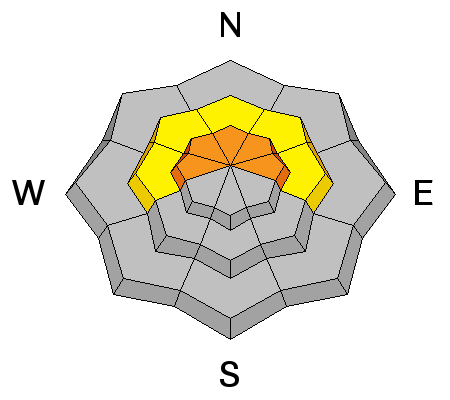
Larger, more dangerous avalanches are possible today, if a slide breaks into a more deeply buried layer of faceted snow. (This layer of near surface facets and recrystallized grauple was buried on Feb 20, and was already covered by 1 to 2 feet of snow from several small storms). These slab avalanches could be 2 to 3 feet deep, and triggered by a person or a smaller new snow slide. These slides can be triggered remotely from a distance. This weak layer is most widespread on upper elevation northeast, north and northwest facing slopes. |
 |
weather The final front is crossing the lake, and should arrive between 9 am and noon. A band of heavy snowfall, up to 2 inches an hour, and a period of increased wind speeds will occur. An additional 4 to 8 inches of snow is possible today, with the upper Cottonwoods receiving as much as a foot. Winds will shift to the northwest late this morning, and settle into the 10 to 20 mph range, with gust to 30. The highest peaks will have gusts in the 40s at times. Temperatures will fall into the single digits at 10,000’. The storm will wrap up by early this evening, with only a few lingering snow flurries tonight, before partial clearing. Temperatures will drop to near zero. Then high pressure will take control, with sunny skies and a gradual warming through next weekend. |
general announcements
|


