| During the month of April, Mark Miller will donate $75 to the charity of your choice (5 to chose from, including the Utah Avalanche Center!) Mark Miller Subaru has raised over $300k in the previous 6 Do Good Feel Good events. More Info here |  |
| During the month of April, Mark Miller will donate $75 to the charity of your choice (5 to chose from, including the Utah Avalanche Center!) Mark Miller Subaru has raised over $300k in the previous 6 Do Good Feel Good events. More Info here | |
| Advisory: Salt Lake Area Mountains | Issued by Bruce Tremper for Monday - March 2, 2015 - 5:53am |
|---|

|
bottom line The danger today depends how fast the storm piles up weight on the pre-existing soft snow. The danger should start at LOW this morning and rise to MODERATE by afternoon as the snow accumulates. As you travel, be sure to test how well the new snow bonds to the underlying snow by jumping on small test slopes and digging down with your hand. The danger may rise to CONSIDERABLE by Tuesday depending on what the storm does.
|
 |
special announcement Backcountry Film Festival at Brewvies, Wednesday, March 4 at 7:00pm: Join us for an evening of nine unique films aimed to inspire winter adventurers to seek the snow less traveledand a killer raffle all while raising funds for the winter human powered experience. This is a benefit for Wasatch Backcountry Alliance and the Utah Avalanche Center *Brewvies is 21+. DETAILS HERE Utah Adventure Journal Snowbird Speaker Series, 6pm Mar 5 at the Wildflower Lounge: The Utah Avalanche Center will be joining the Utah Adventure Journal and friends of Jim Harris, photographer, writer, artist, avalanche observer and instructor in an evening of photos and presentations from Andrew McLean, Kalen Thorien, Noah Howell, Forest McCarthy, and Brendan Leonard. All proceeds will go towards helping to cover Jim's medical & rehab expenses following a kiting accident in Chile. Join us at Brighton Mar 7 & 8 for Vertfest! Clinics include Companion Rescue, Terrain Selection, Steep Skiing, and Mountaineering for skiers/split-boarders, both open and women-only. There will also be gear demos and the Wasatch Powder Keg ski mountaineering race, all to benefit the Utah Avalanche Center. More info here. |
 |
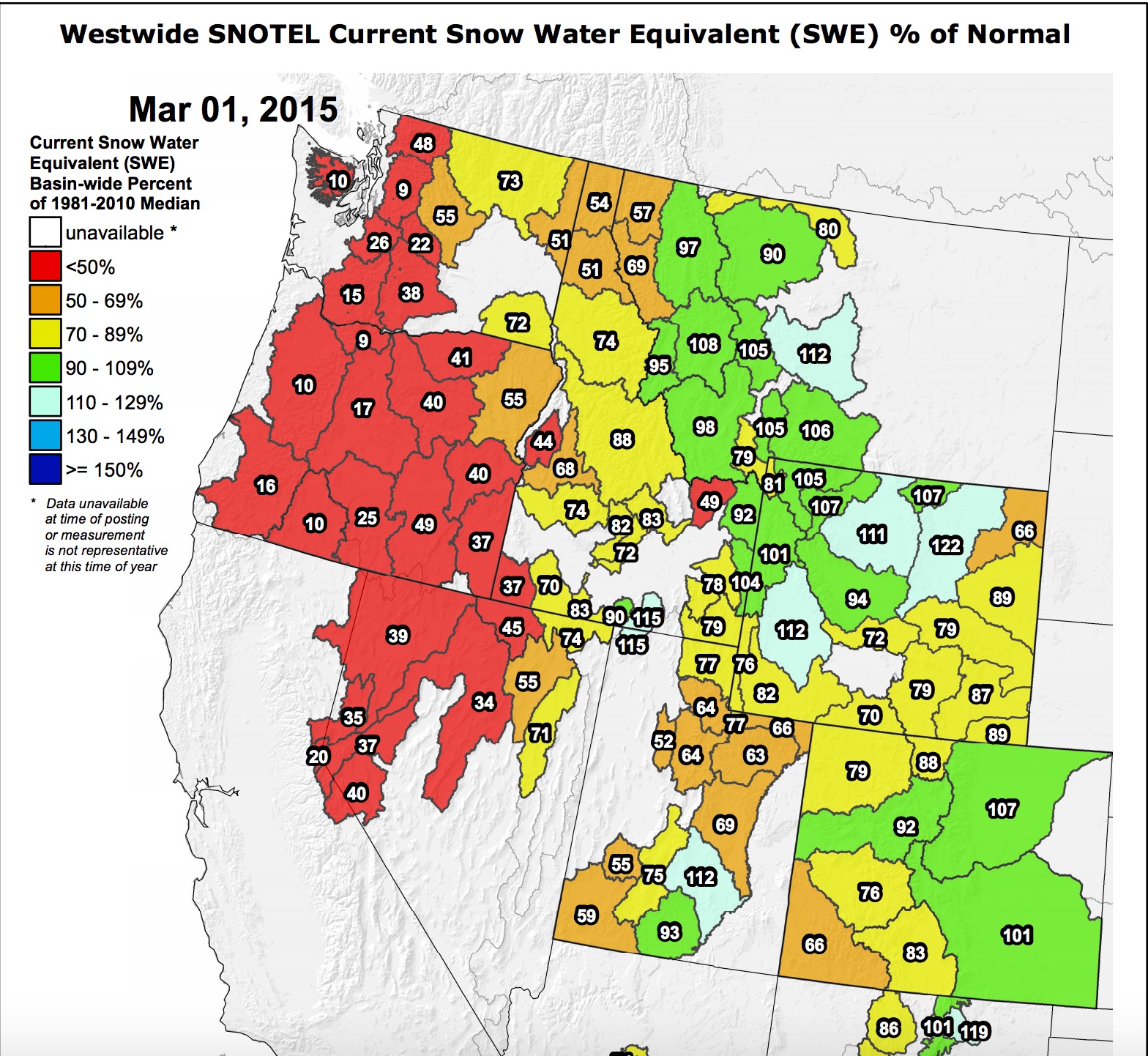
current conditions It's starting to snow this morning as a pulse of moisture arrives from the south. So far, ridge top winds are light. Temperatures are 20 degrees at 9,500'. I'm expecting about 4-8 inches of snow today with snow continuing tonight and into Tuesday. Storm totals could be as much as 2 feet. Which is good because we certainly need the snow: So how bad is our snow drought? HERE is my blog on the current stats. Also check out Jim Steenburg's recent blog.
|
 |
recent activity Not much significant activity yesterday with the exception of a small, skier-triggered sluff on a steep slope on the south face of Superior in the morning. The skier was caught in his own sluff and was carried about 200' before he got out of the sluff before it continued. He lost some poles and broke a ski but was otherwise OK. |
| type | aspect/elevation | characteristics |
|---|

|

|
LIKELIHOOD
 LIKELY
UNLIKELY
SIZE
 LARGE
SMALL
TREND
 INCREASING DANGER
SAME
DECREASING DANGER
|
|
description
The storm beginning this morning has the potential to cause the first significant avalanche problems in about a month and a half. The day will start out at Low danger but as the load accumulates the danger should rise through the day, overnight and especially by Tuesday, we could see some significant activity. The new snow will likely slide on the pre-existing, low density layer of snow that fell over the past 3 days and has the potential to step down to deeper weak layers. As always during a storm, you should continually test how well the new snow bonds to the old snow surfaces by jumping on small, test slopes and digging down with your hand. The avalanche danger through this storm will depend directly on what we call the "precipitation intensity", meaning how fast the storm adds weight as it accumulates. If it starts snowing fast and furious, expect the avalanche danger to spike especially in steep terrain. |
 |
weather Snow is just starting this morning and should continue today, tonight and on Tuesday. I'm expecting 4-8 inches of new snow today and storm totals may reach as much as 2 feet by later on Tuesday. The storm is coming up through southern Utah and has already added over an inch of water weight to the southern mountains. The highest precipitation intensity should occur overnight as the flow turns northwesterly. We expect the wind to remain reasonable today but could pick up tonight to 25, gusting to 35 from the northwest. Temperatures should remain in the mid 20's today but should drop to near zero overnight. For the extended forecast, you should enjoy this snow while you can because we don't see any other snow until around mid March. |
| general announcements
Remember your information can save lives. If you see anything we should know about, please participate in the creation of our own community avalanche advisory by submitting snow and avalanche conditions. You can also call us at 801-524-5304, email by clicking HERE, or include #utavy in your tweet or Instagram. If you trigger an avalanche in the backcountry - especially if you are adjacent to a ski area – please call the following teams to alert them to the slide and whether anyone is missing or not. Rescue teams can be exposed to significant hazard when responding to avalanches, and do not want to do so when unneeded. Thanks. Salt Lake and Park City – Alta Central (801-742-2033), Canyons Resort Dispatch (435-615-3322) Snowbasin Resort Dispatch (801-620-1017), Powder Mountain Dispatch (801-745-3772 x 123). Sundance Dispatch (801-223-4150) EMAIL ADVISORY If you would like to get the daily advisory by email you will need to subscribe here. DAWN PATROL Hotline updated daily by 5-530am - 888-999-4019 option 8. Twitter Updates for your mobile phone - DETAILS UDOT canyon closures: LINK TO UDOT, or on Twitter, follow @UDOTavy, @CanyonAlerts or @AltaCentral Utah Avalanche Center mobile app - Get your advisory on your iPhone along with great navigation and rescue tools. Wasatch Powderbird Guides Blog/Itinerary for the Day. Lost or Found something in the backcountry? - http://nolofo.com/ Discount lift tickets are now available at Backcountry.com. Thanks to Ski Utah and the Utah Resorts. All proceeds go towards paying for Utah Avalanche Center avalanche and mountain weather advisories. To those skinning uphill at resorts: it is your responsibility to know the resort policy on uphill travel. You can see the uphill travel policy for each resort here. IMPORTANT: Before skinning or hiking at a resort under new snow conditions, check in with Ski Patrol. Resorts can restrict or cut off access if incompatible with control and grooming operations. Benefit the Utah Avalanche Center when you shop from Backcountry.com or REI: Click this link for Backcountry.com or this link to REI, shop, and they will donate a percent of your purchase price to the UAC. Both offer free shipping (with some conditions) so this costs you nothing! Benefit the Utah Avalanche Center when you buy or sell on ebay - set the Utah Avalanche Center as a favorite non-profit in your ebay account here and click on ebay gives when you buy or sell. You can choose to have your seller fees donated to the UAC, which doesn't cost you a penny. This information does not apply to developed ski areas or highways where avalanche control is normally done. This advisory is from the U.S.D.A. Forest Service, which is solely responsible for its content. This advisory describes general avalanche conditions and local variations always exist. |