| During the month of April, Mark Miller will donate $75 to the charity of your choice (5 to chose from, including the Utah Avalanche Center!) Mark Miller Subaru has raised over $300k in the previous 6 Do Good Feel Good events. More Info here |  |
| During the month of April, Mark Miller will donate $75 to the charity of your choice (5 to chose from, including the Utah Avalanche Center!) Mark Miller Subaru has raised over $300k in the previous 6 Do Good Feel Good events. More Info here | |
| Advisory: Salt Lake Area Mountains | Issued by Brett Kobernik for Sunday - March 1, 2015 - 6:29am |
|---|

|
bottom line The majority of the terrain has a LOW avalanche danger today. There is a "pockety" MODERATE avalanche danger on steep upper elevation terrain where yesterday's winds created fresh drifts. These drifts are on a variety of aspects and crossloaded terrain features. Keep in mind the wind was from the southeast which loaded west facing slopes, something that we don't always see that often.
|
 |
special announcement Backcountry Film Festival at Brewvies, Wednesday, March 4 at 7:00pm: Join us for an evening of nine unique films aimed to inspire winter adventurers to seek the snow less traveledand a killer raffle all while raising funds for the winter human powered experience. This is a benefit for Wasatch Backcountry Alliance and the Utah Avalanche Center *Brewvies is 21+. DETAILS HERE Utah Adventure Journal Snowbird Speaker Series, 6pm Mar 5 at the Wildflower Lounge: The Utah Avalanche Center will be joining the Utah Adventure Journal and friends of Jim Harris, photographer, writer, artist, avalanche observer and instructor in an evening of photos and presentations from Andrew McLean, Kalen Thorien, Noah Howell, Forest McCarthy, and Brendan Leonard. All proceeds will go towards helping to cover Jim's medical & rehab expenses following a kiting accident in Chile. Join us at Brighton Mar 7 & 8 for Vertfest! Clinics include Companion Rescue, Terrain Selection, Steep Skiing, and Mountaineering for skiers/split-boarders, both open and women-only. There will also be gear demos and the Wasatch Powder Keg ski mountaineering race, all to benefit the Utah Avalanche Center. More info here. |
 |
current conditions Snowfall picked up Saturday afternoon especially on the Park City side of the range which was favored orographically by the southeast wind direction. Totals from the last 24 hours are 4 inches in the upper Cottonwoods and around 7 inches along the Park City ridgeline. The southeast winds picked up yesterday morning and died down in the afternoon. They were light and variable overnight but mostly had a southwest direction. Overnight ridgetop temperatures were in the mid to upper teens and we have cloudy skies this morning. On a side note, yesterday's 4 inches put total snowfall for February at the Alta Guard at 35 inches. The record for the lowest amount recorded in February was in 1950 with 34 inches. We almost did it this year, just like the Seahawks. Year to date snowfall at the Alta Guard is 196 inches. |
 |
recent activity
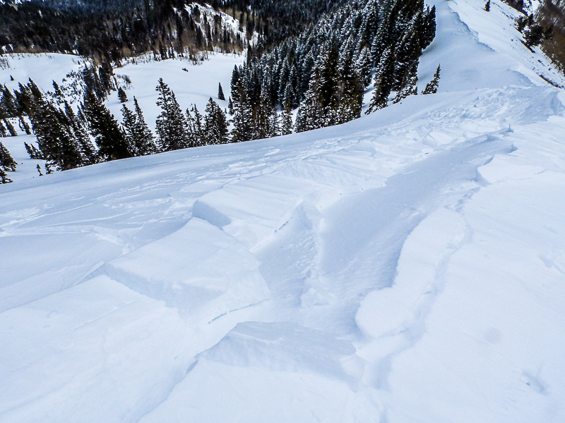
Deepest part of the fracture line from a skier triggered wind slab in South Monitor
South Monitor fracture line tapering off, very typical of wind slabs. Photos: Mark White |
| type | aspect/elevation | characteristics |
|---|

|

|
LIKELIHOOD
 LIKELY
UNLIKELY
SIZE
 LARGE
SMALL
TREND
 INCREASING DANGER
SAME
DECREASING DANGER
|
|
description
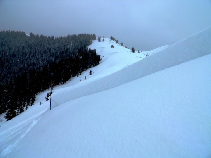
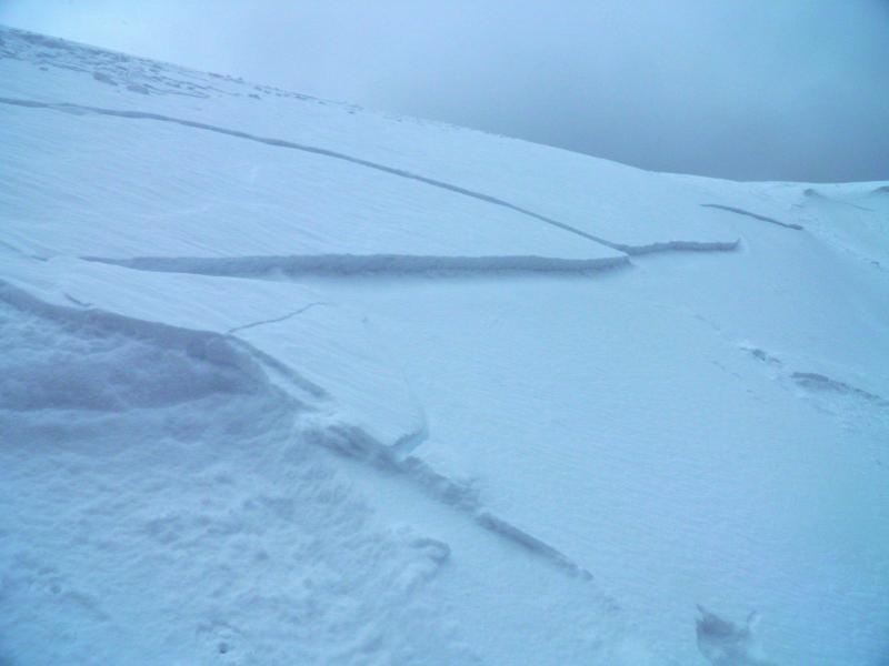
If you are getting into higher terrain you will again want to watch for the fresh slabs which formed on Saturday. They will not be as sensitive but I'm almost positive someone will get one to release today. The threat for burial is not the main concern with these but rather sustaining an injury if you were to get pushed around or dragged over exposed terrain with rocks and trees. If you are aware of this situation and act accordingly, you'll have no problem out there today. It should be noted that a number of the favorite west facing chutes will have wind loaded starting zones. I'm thinking of west facing chutes along the Reed and Benson ridgeline, chutes into Mineral Fork from Cardiff Fork, chutes along Kessler, etc. Slope cuts are appropriate for this situation as long as no one is below. This was demonstrated nicely in this observation from Banana Days. Thanks Kyle Cummings! |
 |
weather We'll see clouds and the slight chance for flurries today. We could see some breaks in the clouds as well mid day. Ridgetop temperatures will get into the low 20s and southwest winds will be light to moderate in speed. Snowfall picks up again tonight into Monday in a southerly flow with slightly warmer temperatures. The last piece of the storm drifts through from the northwest Monday night into mid day Tuesday with colder temperatures again. We could see another 10 inches of snow or better by the time it's all said and done. |
| general announcements
Remember your information can save lives. If you see anything we should know about, please participate in the creation of our own community avalanche advisory by submitting snow and avalanche conditions. You can also call us at 801-524-5304, email by clicking HERE, or include #utavy in your tweet or Instagram. If you trigger an avalanche in the backcountry - especially if you are adjacent to a ski area – please call the following teams to alert them to the slide and whether anyone is missing or not. Rescue teams can be exposed to significant hazard when responding to avalanches, and do not want to do so when unneeded. Thanks. Salt Lake and Park City – Alta Central (801-742-2033), Canyons Resort Dispatch (435-615-3322) Snowbasin Resort Dispatch (801-620-1017), Powder Mountain Dispatch (801-745-3772 x 123). Sundance Dispatch (801-223-4150) EMAIL ADVISORY If you would like to get the daily advisory by email you will need to subscribe here. DAWN PATROL Hotline updated daily by 5-530am - 888-999-4019 option 8. Twitter Updates for your mobile phone - DETAILS UDOT canyon closures: LINK TO UDOT, or on Twitter, follow @UDOTavy, @CanyonAlerts or @AltaCentral Utah Avalanche Center mobile app - Get your advisory on your iPhone along with great navigation and rescue tools. Wasatch Powderbird Guides Blog/Itinerary for the Day. Lost or Found something in the backcountry? - http://nolofo.com/ Discount lift tickets are now available at Backcountry.com. Thanks to Ski Utah and the Utah Resorts. All proceeds go towards paying for Utah Avalanche Center avalanche and mountain weather advisories. To those skinning uphill at resorts: it is your responsibility to know the resort policy on uphill travel. You can see the uphill travel policy for each resort here. IMPORTANT: Before skinning or hiking at a resort under new snow conditions, check in with Ski Patrol. Resorts can restrict or cut off access if incompatible with control and grooming operations. Benefit the Utah Avalanche Center when you shop from Backcountry.com or REI: Click this link for Backcountry.com or this link to REI, shop, and they will donate a percent of your purchase price to the UAC. Both offer free shipping (with some conditions) so this costs you nothing! Benefit the Utah Avalanche Center when you buy or sell on ebay - set the Utah Avalanche Center as a favorite non-profit in your ebay account here and click on ebay gives when you buy or sell. You can choose to have your seller fees donated to the UAC, which doesn't cost you a penny. This information does not apply to developed ski areas or highways where avalanche control is normally done. This advisory is from the U.S.D.A. Forest Service, which is solely responsible for its content. This advisory describes general avalanche conditions and local variations always exist. |