| During the month of April, Mark Miller will donate $75 to the charity of your choice (5 to chose from, including the Utah Avalanche Center!) Mark Miller Subaru has raised over $300k in the previous 6 Do Good Feel Good events. More Info here |  |
| During the month of April, Mark Miller will donate $75 to the charity of your choice (5 to chose from, including the Utah Avalanche Center!) Mark Miller Subaru has raised over $300k in the previous 6 Do Good Feel Good events. More Info here | |
| Advisory: Salt Lake Area Mountains | Issued by Drew Hardesty for Saturday - February 14, 2015 - 5:48am |
|---|

|
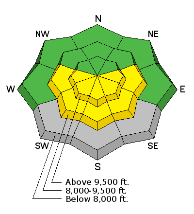
bottom line The danger is mostly LOW this morning before pushing into the MODERATE category for wet avalanches during the heat of the day. Avoid being in the steep sun-exposed terrain when the snow starts to become wet, sloppy, and unsupportable.
|
 |
special announcement If you haven’t caught it yet, check out the recent Utah Adventure Journal article on Drew Hardesty HERE, including his safety oriented Backcountry Project ideas. Backcountry 101 for Snowshoers. Snowshoeing in the backcountry is safer and more fun when you have at least a basic understanding of avalanches. You'll learn about recognizing avalanche terrain and become proficient in companion rescue. Join us Thursday February 19th from 5:30-8:30pm and Saturday February 21st from 8:30am-4:00pm. Space is limited. Sign up HERE. Women's Intro to Avalanches at Snowbasin. Join us February 19th and 21st for a Women's Intro to Avalanches at Snowbasin. This workshop begins with a three hour evening class in Ogden, followed by a 6 hour on-the-snow field day. Taught by Paige Pagnucco, Evelyn Lees and several others from the Utah Avalanche Center and members of Snowbasin Ski Patrol. Space is limited. Sign up HERE. |
 |
current conditions Skies are clear to partly cloudy along the Wasatch Range. Winds are generally light from the west; temps are in the upper 30s and low 40s. Snow surface conditions range from February corn on the southerlies to soft settled dense powder in the sheltered northerly terrain. It must be spring. Some outings begin and end on dirt...tulips and crocuses are pushing through the dirt in the front yard. My neighbor's lawn sprinklers came on yesterday.
|
 |
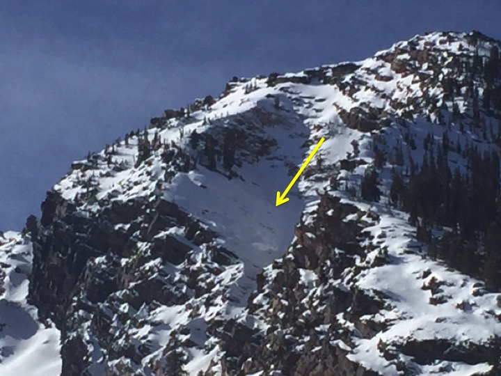
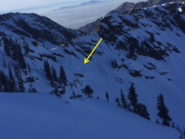
recent activity My party noted some glide cracks and buckling of the snow in Broads Fork and Mill B South. One of the usual suspects - a small smooth unsupported rocky slab in Mill B South - had recently shed it's winter coat.
|
| type | aspect/elevation | characteristics |
|---|

|
|
LIKELIHOOD
 LIKELY
UNLIKELY
SIZE
 LARGE
SMALL
TREND
 INCREASING DANGER
SAME
DECREASING DANGER
|
|
description
While large avalanches are unlikely today, there are several types of small avalanches could be triggered. Even a small avalanche can be dangerous in more radical terrain, if it pushes you off a cliff, into trees or takes you for a very long ride.
|
 |
weather We'll have partly cloudy skies, light westerly wind, and mountain temps in the mid-40s at 10,000', the mid-50s at 8000'. A brush-by to the north will bring cooler temps tomorrow with some additional cloud cover Monday/Tuesday. Temps rebound for mid-week. |
| general announcements
Remember your information can save lives. If you see anything we should know about, please participate in the creation of our own community avalanche advisory by submitting snow and avalanche conditions. You can also call us at 801-524-5304, email by clicking HERE, or include #utavy in your tweet or Instagram. If you trigger an avalanche in the backcountry - especially if you are adjacent to a ski area – please call the following teams to alert them to the slide and whether anyone is missing or not. Rescue teams can be exposed to significant hazard when responding to avalanches, and do not want to do so when unneeded. Thanks. Salt Lake and Park City – Alta Central (801-742-2033), Canyons Resort Dispatch (435-615-3322) Snowbasin Resort Dispatch (801-620-1017), Powder Mountain Dispatch (801-745-3772 x 123). Sundance Dispatch (801-223-4150) EMAIL ADVISORY If you would like to get the daily advisory by email you will need to subscribe here. DAWN PATROL Hotline updated daily by 5-530am - 888-999-4019 option 8. Twitter Updates for your mobile phone - DETAILS UDOT canyon closures: LINK TO UDOT, or on Twitter, follow @UDOTavy, @CanyonAlerts or @AltaCentral Utah Avalanche Center mobile app - Get your advisory on your iPhone along with great navigation and rescue tools. Wasatch Powderbird Guides Blog/Itinerary for the Day. Lost or Found something in the backcountry? - http://nolofo.com/ Discount lift tickets are now available at Backcountry.com. Thanks to Ski Utah and the Utah Resorts. All proceeds go towards paying for Utah Avalanche Center avalanche and mountain weather advisories. To those skinning uphill at resorts: it is your responsibility to know the resort policy on uphill travel. You can see the uphill travel policy for each resort here. IMPORTANT: Before skinning or hiking at a resort under new snow conditions, check in with Ski Patrol. Resorts can restrict or cut off access if incompatible with control and grooming operations. Benefit the Utah Avalanche Center when you shop from Backcountry.com or REI: Click this link for Backcountry.com or this link to REI, shop, and they will donate a percent of your purchase price to the UAC. Both offer free shipping (with some conditions) so this costs you nothing! Benefit the Utah Avalanche Center when you buy or sell on ebay - set the Utah Avalanche Center as a favorite non-profit in your ebay account here and click on ebay gives when you buy or sell. You can choose to have your seller fees donated to the UAC, which doesn't cost you a penny. This information does not apply to developed ski areas or highways where avalanche control is normally done. This advisory is from the U.S.D.A. Forest Service, which is solely responsible for its content. This advisory describes general avalanche conditions and local variations always exist. |