| During the month of April, Mark Miller will donate $75 to the charity of your choice (5 to chose from, including the Utah Avalanche Center!) Mark Miller Subaru has raised over $300k in the previous 6 Do Good Feel Good events. More Info here |  |
| During the month of April, Mark Miller will donate $75 to the charity of your choice (5 to chose from, including the Utah Avalanche Center!) Mark Miller Subaru has raised over $300k in the previous 6 Do Good Feel Good events. More Info here | |
| Advisory: Salt Lake Area Mountains | Issued by Drew Hardesty for Sunday - February 8, 2015 - 5:48am |
|---|

|
bottom line The danger for wet avalanches will rise to MODERATE on all aspects and elevations but for the high northerlies. Human triggered wet sluffs and wet slabs will be likely in the dampened and wet snow with sun and daytime heating. Springtime exits (start early-finish early) are key to avoid being in or below unsupportable wet snow in steep terrain. Pockets of lingering wind drifts may also be found in the high alpine terrain generally facing north through east. Cornices will again be sensitive today.
|
 |
special announcement Jim Steenburgh's blog Wasatch Weather Weenies offers some perspective on our current weather pattern. Jim's an Atmospheric Sciences professor at the University of Utah, author of the recent book Secrets of the Greatest Snow on Earth, and avid backcountry skier (and not necessarily in that order). Be confident in your backcountry rescue skills. Join us Monday February 9th for a Companion Rescue Workshop from 5:30-9pm at Brighton. For more info or to sign up - click here. The first clinic last week was a great success thanks to long-time Wasatch Backcountry Rescue specialist and Brighton ski patroller Brandon Dodge. Below are a couple pics from yesterday's avalanche clinic up in Logan with UAC forecast staff Toby Weed and Paige Pagnucco.
|
 |
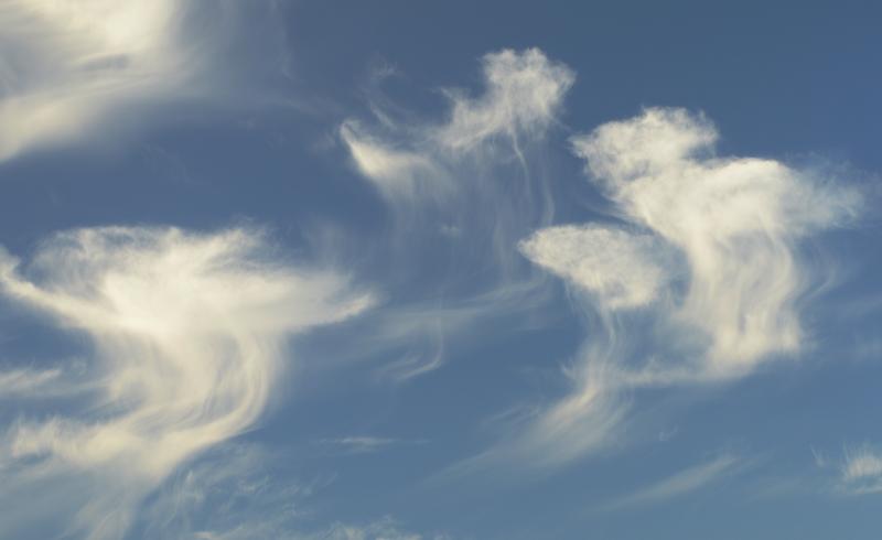
current conditions Scattered clouds should give way to clearing skies this morning. Mountain temperatures dipped to the upper 20s and low 30s for many stations last night but they've gained a couple degrees in the last couple of hours. Many stations in the mid-elevation "thermal belt" outside of the Cottonwoods remain in the upper 30s and low 40s. Winds followed a rollercoaster of westerly directions and speeds yesterday and overnight and are now blowing 15-20mph with gusts to 30. The highest ridgelines have speeds of 25 with gusts to 40...though things should quiet down through the day. Precipitation with these impulses came as mist though much of it never hit the ground - something called virga. It can be quite beautiful sometimes - see below -
Clouds trailing streams of virga, like some giant sky-dwelling jellyfish given to the great whims of weather and wind as currents and tides of the sea. |
 |
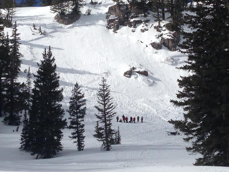
recent activity Yesterday a skier moving along the upper ridgeline above Michigan City in upper LCC remotely triggered a cornice fall which then pulled out a fresh wind slab in upper Honeycomb canyon. |
| type | aspect/elevation | characteristics |
|---|

|
|
LIKELIHOOD
 LIKELY
UNLIKELY
SIZE
 LARGE
SMALL
TREND
 INCREASING DANGER
SAME
DECREASING DANGER
|
|
description
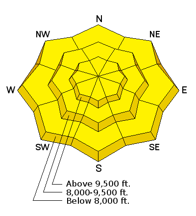
Scattered pockets of soft and hard wind slabs may be found at the mid and upper elevations and not necessarily confined to the ridgelines. Most of these should be stubborn and fairly well welded in as time and warm temps assist in stabilization. Take a moment and click on the 'i' next to the Wind Slab graphic for more info. |
| type | aspect/elevation | characteristics |
|---|

|
|
LIKELIHOOD
 LIKELY
UNLIKELY
SIZE
LARGE
SMALL
TREND
 INCREASING DANGER
SAME
DECREASING DANGER
|
|
description
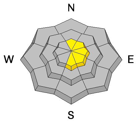
There may be a superficial refreeze on many snow surfaces this morning, but they should rapidly soften with sun and daytime heating. For some areas, the frozen melt-freeze crust caps and conceals varying degrees of free water and melting within the snowpack. For binding grains together, a touch of water is ok, too much water is not. It also depends if that water is pooling at or within a certain layer..or draining out. In other words, how good is the plumbing and piping in the snowpack? For this reason, I'm inclined to throw wet slabs in with the standard wet loose avalanches today and they may be more pronounced at the mid-elevation southerly aspects. I can't believe I'm writing this in early February. Glide avalanches in the classic drainages of Stairs, Broads, and to some extent Mill B South of BCC are possible. Take a moment and click on the 'i' next to the Wet Avalanche graphic for more info. |
| type | aspect/elevation | characteristics |
|---|

|

|
LIKELIHOOD
 LIKELY
UNLIKELY
SIZE
LARGE
SMALL
TREND
INCREASING DANGER
SAME
DECREASING DANGER
|
|
description
Mid and upper elevation ridgelines harbor cornices that will be prone to failure today. These may release on approach and break back well beyond the apex of the ridgeline. A spotter positioned to the side who can see the entirety of the ridge and cornice may be helpful. |
 |
weather We'll have a quick day of clear skies before a clipper to the north spills some cooler temps and a touch of precipitation our way Monday and Tuesday. Mountain temps will reach into the mid-30s at 10,000' and the mid-40s at 8000'. Winds should be 15mph from the west and northwest. Monday morning's cold front should drop temps back to the low 20s at 10,000'...while kicking in a couple inches of snow to boot. The storm rolls through, closes off, then dives south, as we once again sit under a blocking pattern through the rest of the week. The long term models offer some glimmer of hope for a couple weeks out. |
| general announcements
Remember your information can save lives. If you see anything we should know about, please participate in the creation of our own community avalanche advisory by submitting snow and avalanche conditions. You can also call us at 801-524-5304, email by clicking HERE, or include #utavy in your tweet or Instagram. If you trigger an avalanche in the backcountry - especially if you are adjacent to a ski area – please call the following teams to alert them to the slide and whether anyone is missing or not. Rescue teams can be exposed to significant hazard when responding to avalanches, and do not want to do so when unneeded. Thanks. Salt Lake and Park City – Alta Central (801-742-2033), Canyons Resort Dispatch (435-615-3322) Snowbasin Resort Dispatch (801-620-1017), Powder Mountain Dispatch (801-745-3772 x 123). Sundance Dispatch (801-223-4150) EMAIL ADVISORY If you would like to get the daily advisory by email you will need to subscribe here. DAWN PATROL Hotline updated daily by 5-530am - 888-999-4019 option 8. Twitter Updates for your mobile phone - DETAILS UDOT canyon closures: LINK TO UDOT, or on Twitter, follow @UDOTavy, @CanyonAlerts or @AltaCentral Utah Avalanche Center mobile app - Get your advisory on your iPhone along with great navigation and rescue tools. Wasatch Powderbird Guides Blog/Itinerary for the Day. Lost or Found something in the backcountry? - http://nolofo.com/ Discount lift tickets are now available at Backcountry.com. Thanks to Ski Utah and the Utah Resorts. All proceeds go towards paying for Utah Avalanche Center avalanche and mountain weather advisories. To those skinning uphill at resorts: it is your responsibility to know the resort policy on uphill travel. You can see the uphill travel policy for each resort here. IMPORTANT: Before skinning or hiking at a resort under new snow conditions, check in with Ski Patrol. Resorts can restrict or cut off access if incompatible with control and grooming operations. Benefit the Utah Avalanche Center when you shop from Backcountry.com or REI: Click this link for Backcountry.com or this link to REI, shop, and they will donate a percent of your purchase price to the UAC. Both offer free shipping (with some conditions) so this costs you nothing! Benefit the Utah Avalanche Center when you buy or sell on ebay - set the Utah Avalanche Center as a favorite non-profit in your ebay account here and click on ebay gives when you buy or sell. You can choose to have your seller fees donated to the UAC, which doesn't cost you a penny. This information does not apply to developed ski areas or highways where avalanche control is normally done. This advisory is from the U.S.D.A. Forest Service, which is solely responsible for its content. This advisory describes general avalanche conditions and local variations always exist. |