| During the month of April, Mark Miller will donate $75 to the charity of your choice (5 to chose from, including the Utah Avalanche Center!) Mark Miller Subaru has raised over $300k in the previous 6 Do Good Feel Good events. More Info here |  |
| During the month of April, Mark Miller will donate $75 to the charity of your choice (5 to chose from, including the Utah Avalanche Center!) Mark Miller Subaru has raised over $300k in the previous 6 Do Good Feel Good events. More Info here | |
| Advisory: Salt Lake Area Mountains | Issued by Brett Kobernik for Monday - January 26, 2015 - 6:54am |
|---|

|
bottom line The avalanche danger may rise to CONSIDERABLE during daytime heating. I am quite unsure just how the snowpack will react to the anticipated very warm temperatures so forecast confidence is low. Avoid being on or below steep sunny slopes as they heat up starting with east facing first and working south then west as the sun moves during the day. Today is an obvious day to avoid slopes like the southeast face of Mt Superior.
|
 |
current conditions Wow. Temperatures have been increasing over the last 6 hours and are in the mid 30s to 40 degrees along the ridges already. Wind speeds increased for a period overnight but have really backed off now and are from the northeast. |
 |
recent activity There were a number of skier triggered wet loose avalanches on Sunday. One was on a steep east facing slope in the lower Meadow Chutes. DETAILS An other was a bit larger on the southeast face of Mt Superior mid day. A few more were reported on Superior late in the day as well. |
| type | aspect/elevation | characteristics |
|---|

|
|
LIKELIHOOD
 LIKELY
UNLIKELY
SIZE
 LARGE
SMALL
TREND
 INCREASING DANGER
SAME
DECREASING DANGER
|
|
description
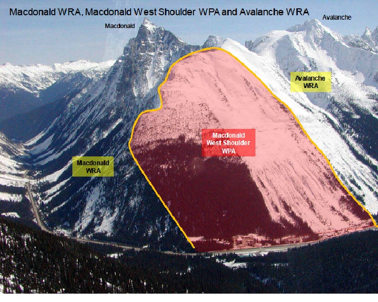
Record high temperatures today will demand you pay attention to the sunny slopes. There are some factors which make me think we won't see too much wet activity but other factors and the unprecedented high temperatures make me very unsure. IF we see wet avalanches, they could pile up some substantial debris. A number of people were ascending and descending the southeast face of Superior late morning and into the afternoon on Sunday. Snow safety teams at Snowbird, Alta, UDOT as well as Powderbirds and any savvy backcountry skiers who watch the spectacle scratch their heads at this. If you are unaware of why they scratch their heads it's because steep southeast facing slopes are the first to heat up and have the most likely chance for wet avalanche activity mid day. If you get it early enough, no worries, but during the heat of the day is a different story. On a side note, this is an ongoing issue on Mt Superior. My own thoughts on this make me wonder how long UDOT and the Sherriff will watch people trigger avalanches above an open road. I hate to say it but I suspect we will see closures of this terrain at some point. It is not unprecedented, look at Roger's Pass: WPA is "Winter Prohibited Area" WRA is "Winter Restricted Area" |
 |
weather It's going to be a warm one with ridgetop temperatures perhaps reaching 45 degrees. Winds will be pretty light from the east and southeast. We have an odd storm that will move through from the south on Tuesday into Wednesday but it's not looking all that great for much more than about 3 inches of snow, 6 inches if we're lucky. |
| general announcements
Remember your information can save lives. If you see anything we should know about, please participate in the creation of our own community avalanche advisory by submitting snow and avalanche conditions. You can also call us at 801-524-5304, email by clicking HERE, or include #utavy in your tweet or Instagram. If you trigger an avalanche in the backcountry - especially if you are adjacent to a ski area – please call the following teams to alert them to the slide and whether anyone is missing or not. Rescue teams can be exposed to significant hazard when responding to avalanches, and do not want to do so when unneeded. Thanks. Salt Lake and Park City – Alta Central (801-742-2033), Canyons Resort Dispatch (435-615-3322) Snowbasin Resort Dispatch (801-620-1017), Powder Mountain Dispatch (801-745-3772 x 123). Sundance Dispatch (801-223-4150) EMAIL ADVISORY If you would like to get the daily advisory by email you will need to subscribe here. DAWN PATROL Hotline updated daily by 5-530am - 888-999-4019 option 8. Twitter Updates for your mobile phone - DETAILS UDOT canyon closures: LINK TO UDOT, or on Twitter, follow @UDOTavy, @CanyonAlerts or @AltaCentral Utah Avalanche Center mobile app - Get your advisory on your iPhone along with great navigation and rescue tools. Wasatch Powderbird Guides Blog/Itinerary for the Day. Lost or Found something in the backcountry? - http://nolofo.com/ Discount lift tickets are now available at Backcountry.com. Thanks to Ski Utah and the Utah Resorts. All proceeds go towards paying for Utah Avalanche Center avalanche and mountain weather advisories. To those skinning uphill at resorts: it is your responsibility to know the resort policy on uphill travel. You can see the uphill travel policy for each resort here. IMPORTANT: Before skinning or hiking at a resort under new snow conditions, check in with Ski Patrol. Resorts can restrict or cut off access if incompatible with control and grooming operations. Benefit the Utah Avalanche Center when you shop from Backcountry.com or REI: Click this link for Backcountry.com or this link to REI, shop, and they will donate a percent of your purchase price to the UAC. Both offer free shipping (with some conditions) so this costs you nothing! Benefit the Utah Avalanche Center when you buy or sell on ebay - set the Utah Avalanche Center as a favorite non-profit in your ebay account here and click on ebay gives when you buy or sell. You can choose to have your seller fees donated to the UAC, which doesn't cost you a penny. This information does not apply to developed ski areas or highways where avalanche control is normally done. This advisory is from the U.S.D.A. Forest Service, which is solely responsible for its content. This advisory describes general avalanche conditions and local variations always exist. |