| During the month of April, Mark Miller will donate $75 to the charity of your choice (5 to chose from, including the Utah Avalanche Center!) Mark Miller Subaru has raised over $300k in the previous 6 Do Good Feel Good events. More Info here |  |
| During the month of April, Mark Miller will donate $75 to the charity of your choice (5 to chose from, including the Utah Avalanche Center!) Mark Miller Subaru has raised over $300k in the previous 6 Do Good Feel Good events. More Info here | |
| Advisory: Salt Lake Area Mountains | Issued by Evelyn Lees for Wednesday - January 21, 2015 - 6:32am |
|---|

|
bottom line The avalanche danger is LOW. While generally safe avalanche conditions exist, unstable snow could occur on isolated terrain features. If you are in steep or radical terrain, have a defensive attitude – even a small slide can have serious consequences if it takes you off a cliff, for a long ride through rocks or into trees.
|
 |
special announcement This Thursday at the Wildflower Lounge at Snowbird, Doug Stoup will be presenting Skiing the Planet. Doug recently returned from filming in Greenland for Animal Planet's #1 show called Ice Cold Gold. Doug is an expedition leader, ski mountaineering guide, polar guide, philanthropist, professional speaker, stand up paddler and father. The free talk is at 6:00pm and a raffle benefits the Utah Avalanche Center. |
 |
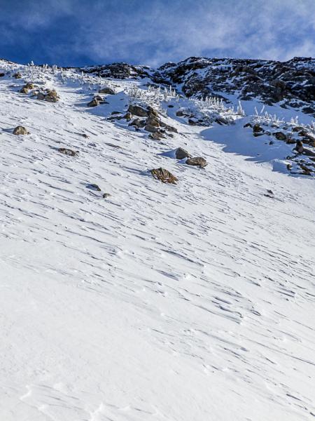
current conditions It’s a beautiful cold, clear morning in the mountains, with temperatures in the teens at most elevations. The few single digit readings are in the canyon bottoms, where the cold air has pooled. The northerly winds are currently very light – averaging less than 10 mph at most stations. Just a few of the highest peaks have average speeds to 20 mph. Mid to upper elevation, wind sheltered shady slopes still offer a bit of soft snow. Elsewhere, it’s mostly a mix of breakable sun and wind crusts. Watch out for hitting rocks and stumps in shallow snowpack areas, which exist on almost all aspects and elevations. Left: wind hammered alpine snow (pc todd Leeds)
|
 |
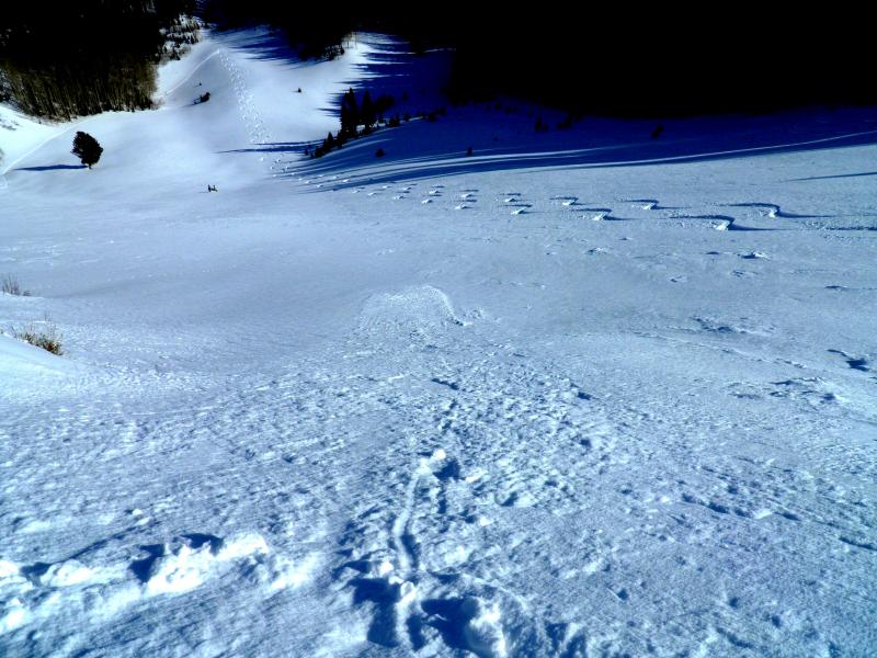
recent activity No avalanche activity was reported from the backcountry yesterday, though the snow is starting to sluff in the steepest terrain. You can always check out the season’s avalanche history on our Avalanche page. Small sluff in steep terrain (pc Mark White)
|
| type | aspect/elevation | characteristics |
|---|

|
|
LIKELIHOOD
 LIKELY
UNLIKELY
SIZE
 LARGE
SMALL
TREND
 INCREASING DANGER
SAME
DECREASING DANGER
|
|
description
The weather is starting to bore both the snow pack and the forecasters. I find this sometimes makes it even harder to focus on the small, but important snow pack details and low risk travel procedures that help keep you safe. Even with a generally LOW danger, today’s concerns include:
|
 |
weather Winter could really use a jump start, but none is in sight. We’ll have another day of clear skies and cool temperatures as a northerly flow keeps the air mass cold. Highs today will be in the mid-20s at 8,000’, and in the teens at 10,000. The northerly winds will increase slightly as the day goes on – late afternoon speeds could reach 25 to 35 mph averages across the highest peaks. It will be clear and cold again tonight, with temperatures dropping into the single digits to near zero. High pressure will dominate through Tuesday, with Monday looking to be the warmest day. |
| general announcements Remember your information can save lives. If you see anything we should know about, please participate in the creation of our own community avalanche advisory by submitting snow and avalanche conditions. You can also call us at 801-524-5304, email by clicking HERE, or include #utavy in your tweet or Instagram. If you trigger an avalanche in the backcountry - especially if you are adjacent to a ski area – please call the following teams to alert them to the slide and whether anyone is missing or not. Rescue teams can be exposed to significant hazard when responding to avalanches, and do not want to do so when unneeded. Thanks. Salt Lake and Park City – Alta Central (801-742-2033), Canyons Resort Dispatch (435-615-3322) Snowbasin Resort Dispatch (801-620-1017), Powder Mountain Dispatch (801-745-3772 x 123). Sundance Dispatch (801-223-4150) EMAIL ADVISORY If you would like to get the daily advisory by email you will need to subscribe here. DAWN PATROL Hotline updated daily by 5-530am - 888-999-4019 option 8. Twitter Updates for your mobile phone - DETAILS UDOT canyon closures: LINK TO UDOT, or on Twitter, follow @UDOTavy, @CanyonAlerts or @AltaCentral Utah Avalanche Center mobile app - Get your advisory on your iPhone along with great navigation and rescue tools. Wasatch Powderbird Guides Blog/Itinerary for the Day. Lost or Found something in the backcountry? - http://nolofo.com/ Discount lift tickets are now available at Backcountry.com. Thanks to Ski Utah and the Utah Resorts. All proceeds go towards paying for Utah Avalanche Center avalanche and mountain weather advisories. To those skinning uphill at resorts: it is your responsibility to know the resort policy on uphill travel. You can see the uphill travel policy for each resort here. IMPORTANT: Before skinning or hiking at a resort under new snow conditions, check in with Ski Patrol. Resorts can restrict or cut off access if incompatible with control and grooming operations. Benefit the Utah Avalanche Center when you shop from Backcountry.com or REI: Click this link for Backcountry.com or this link to REI, shop, and they will donate a percent of your purchase price to the UAC. Both offer free shipping (with some conditions) so this costs you nothing! Benefit the Utah Avalanche Center when you buy or sell on ebay - set the Utah Avalanche Center as a favorite non-profit in your ebay account here and click on ebay gives when you buy or sell. You can choose to have your seller fees donated to the UAC, which doesn't cost you a penny. This information does not apply to developed ski areas or highways where avalanche control is normally done. This advisory is from the U.S.D.A. Forest Service, which is solely responsible for its content. This advisory describes general avalanche conditions and local variations always exist. |