| During the month of April, Mark Miller will donate $75 to the charity of your choice (5 to chose from, including the Utah Avalanche Center!) Mark Miller Subaru has raised over $300k in the previous 6 Do Good Feel Good events. More Info here |  |
| During the month of April, Mark Miller will donate $75 to the charity of your choice (5 to chose from, including the Utah Avalanche Center!) Mark Miller Subaru has raised over $300k in the previous 6 Do Good Feel Good events. More Info here | |
| Advisory: Salt Lake Area Mountains | Issued by Drew Hardesty for Thursday - January 15, 2015 - 6:13am |
|---|

|
bottom line A MODERATE danger for wind drifts should be stabilizing by day's end. You may find these pockets scattered across the compass and generally just off the ridgelines. The danger for wet loose and wet slab avalanches will rise toward CONSIDERABLE with daytime heating and direct sun. Travel Tip - Be off of and out from underneath the steep sunlit slopes by midday. The best and safest terrain will be in shady sheltered mid-elevation glades.
|
 |
current conditions Bluebird. Mountain temps are in the mid to upper 20s along the ridgelines, the mid teens in the basins and valleys. Winds remain north to northeasterly blowing less than 15mph. Riding conditions remain good but for some wind damage in open exposed terrain...and the southerlies which will sport a melt-freeze crust this am from yesterday's sun. |
 |
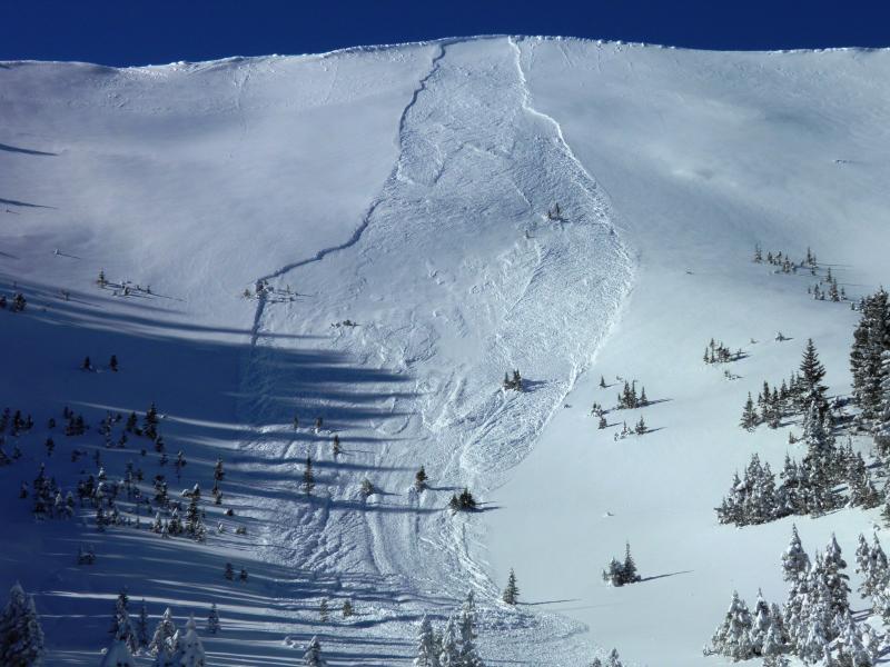
recent activity A number of avalanches reported from the backcountry that included a few skier and sled-triggered wind drifts from Tuesday's gusty northeast winds..and a couple new glide releases in Broads Fork of BCC. The details - (go to wbskiing.com for locations)
|
| type | aspect/elevation | characteristics |
|---|

|

|
LIKELIHOOD
 LIKELY
UNLIKELY
SIZE
 LARGE
SMALL
TREND
 INCREASING DANGER
SAME
DECREASING DANGER
|
|
description
With direct sun and mountain temperatures expected to rise into the mid-30s at 10,000' and the mid-40s at 8000', human triggered wet sluffs and a few wet slabs today are all but certain. TIMING WILL BE KEY! Those late to the game on steep sustained southerlies can expect to trigger wet slides that'll easily gouge into the storm snow from the weekend, producing healthy, if bone-snapping, debris piles. Roller balls, pinwheels, natural sluffs, snow falling from trees are all signs that you may be too late in heading into steep sun-exposed terrain. Click on the 'i' next to the Wet Avalanche icon for more info -
|
| type | aspect/elevation | characteristics |
|---|

|

|
LIKELIHOOD
 LIKELY
UNLIKELY
SIZE
 LARGE
SMALL
TREND
 INCREASING DANGER
SAME
DECREASING DANGER
|
|
description
Rapidly warming temps should keep these on your radar for just another day. These left-over wind drifts from Tuesday's northeasterlies are generally 1-2' deep and on a variety of aspects due to forcing and terrain channeling. Most have settled out...and any lingering pockets will generally respond well to slope cuts and cornice drops. Other tracks on the slope are typically reliable indicators of slope-specific stability. New Snow Instabilities tend to spike with the storm...and then rapidly settle out. It's much like a EKG chart - as depicted below. It's why, if you go to a certain piece of terrain often, follow the snow, weather, and avalanche history and do the homework, you're able to ride certain terrain. Be honest with yourself about whether you're as diligent as you think you are. Another point - we all have varying levels of risk tolerance. A key word here is 'tolerance'. Click on the 'i' next to the Wind Slab icon for more info -
|
| type | aspect/elevation | characteristics |
|---|

|
|
LIKELIHOOD
 LIKELY
UNLIKELY
SIZE
 LARGE
SMALL
TREND
 INCREASING DANGER
SAME
DECREASING DANGER
|
|
description
Don't be that guy. It just takes one. Don't be the guy or gal who is too late to be in the steep south facing terrain above Little Cottonwood Canyon today and triggers a wet slide across the road or on top of other skiers/riders below.
|
 |
weather It'll be another grand day in the Wasatch with clear skies, generally light wind and temps in the 30s and 40s. High pressure and clear skies will slowly give way to increasing clouds tomorrow ahead of the first of a couple weak going-through-the-motions weather systems for Friday and again Sun/Mon. The weather models don't agree on much for next week - we'll let the next couple model runs work things out. Check back for our Mtn WX forecast each day by about noon. |
| general announcements
Remember your information can save lives. If you see anything we should know about, please participate in the creation of our own community avalanche advisory by submitting snow and avalanche conditions. You can also call us at 801-524-5304, email by clicking HERE, or include #utavy in your tweet or Instagram. If you trigger an avalanche in the backcountry - especially if you are adjacent to a ski area – please call the following teams to alert them to the slide and whether anyone is missing or not. Rescue teams can be exposed to significant hazard when responding to avalanches, and do not want to do so when unneeded. Thanks. Salt Lake and Park City – Alta Central (801-742-2033), Canyons Resort Dispatch (435-615-3322) Snowbasin Resort Dispatch (801-620-1017), Powder Mountain Dispatch (801-745-3772 x 123). Sundance Dispatch (801-223-4150) EMAIL ADVISORY If you would like to get the daily advisory by email you will need to subscribe here. DAWN PATROL Hotline updated daily by 5-530am - 888-999-4019 option 8. Twitter Updates for your mobile phone - DETAILS UDOT canyon closures: LINK TO UDOT, or on Twitter, follow @UDOTavy, @CanyonAlerts or @AltaCentral Utah Avalanche Center mobile app - Get your advisory on your iPhone along with great navigation and rescue tools. Wasatch Powderbird Guides Blog/Itinerary for the Day. Lost or Found something in the backcountry? - http://nolofo.com/ Discount lift tickets are now available at Backcountry.com. Thanks to Ski Utah and the Utah Resorts. All proceeds go towards paying for Utah Avalanche Center avalanche and mountain weather advisories. To those skinning uphill at resorts: it is your responsibility to know the resort policy on uphill travel. You can see the uphill travel policy for each resort here. IMPORTANT: Before skinning or hiking at a resort under new snow conditions, check in with Ski Patrol. Resorts can restrict or cut off access if incompatible with control and grooming operations. Benefit the Utah Avalanche Center when you shop from Backcountry.com or REI: Click this link for Backcountry.com or this link to REI, shop, and they will donate a percent of your purchase price to the UAC. Both offer free shipping (with some conditions) so this costs you nothing! Benefit the Utah Avalanche Center when you buy or sell on ebay - set the Utah Avalanche Center as a favorite non-profit in your ebay account here and click on ebay gives when you buy or sell. You can choose to have your seller fees donated to the UAC, which doesn't cost you a penny. This information does not apply to developed ski areas or highways where avalanche control is normally done. This advisory is from the U.S.D.A. Forest Service, which is solely responsible for its content. This advisory describes general avalanche conditions and local variations always exist. |