| During the month of April, Mark Miller will donate $75 to the charity of your choice (5 to chose from, including the Utah Avalanche Center!) Mark Miller Subaru has raised over $300k in the previous 6 Do Good Feel Good events. More Info here |  |
| During the month of April, Mark Miller will donate $75 to the charity of your choice (5 to chose from, including the Utah Avalanche Center!) Mark Miller Subaru has raised over $300k in the previous 6 Do Good Feel Good events. More Info here | |
| Advisory: Salt Lake Area Mountains | Issued by Bruce Tremper for Monday - January 12, 2015 - 5:28am |
|---|

|
bottom line The avalanche danger will start out Low this morning and will probably creep into the Moderate category as the snow accumulates this afternoon and evening. Be sure to jump on small test slopes and regularly dig down with your hand to test how well the new snow is bonding and adjust your terrain accordingly.
|
 |
special announcement
For more info and to sign up for this killer event, click here - |
 |
current conditions A couple inches of snow Saturday night gave us some dust-on-crust conditions yesterday and another inch fell overnight. Our first coat of paint helped to improve the turning and riding conditions from the widespread hard crusts of various kinds. Our second coat of paint will arrive later this afternoon with perhaps another 5 inches.
|
 |
recent activity No avalanches reported from yesterday. |
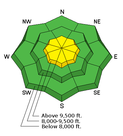
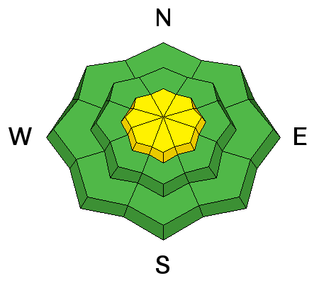
| type | aspect/elevation | characteristics |
|---|

|
|
LIKELIHOOD
 LIKELY
UNLIKELY
SIZE
 LARGE
SMALL
TREND
 INCREASING DANGER
SAME
DECREASING DANGER
|
|
description
Storm snow will give us our only avalanche concern for today. We're expecting another 5 inches-or-so of new snow this afternoon and evening without too much wind. So I don't think that will change the avalanche danger very much, perhaps barely bump it into the Moderate category. As the snow arrives and accumulates, watch for the usual sluffs and soft slabs within the new snow. The cool thing about new snow is that everything is right on the surface and easy to test. Jump on small test slopes as you travel and regularly dig down to test the bonding within the new snow and how well it's bonding with the slick ice crusts underneath. Slabs can occur within the new snow because of an increase in precipitation intensity, wind or temperature fluctuations within the storm. So our avalanche advice during a storm is usually in the form of if-then statements: IF we get more snow than forecast or IF the winds pick up or IF we get temperature fluctuations within the storm, THEN the avalanche danger will bump up a notch. In other words, pay attention to obvious clues as you travel today and adjust your terrain accordingly. |
 |
weather The cold front will arrive later this afternoon and give us about 5 inches of new snow without too much wind. The flow turns northerly very quickly this evening so we probably won't get much more new snow overnight or on Tuesday, just some additional, light snow showers. The rain-snow line should start out around 7,000' this morning and drop to near the valley floor tonight and on Tuesday. Wind should remain fairly light but bump up to 20 mph, gusting to 30 on the exposed peaks as the cold front passes this afternoon. Temperatures should be in the upper 20's today and drop into the mid teens tonight and on Monday. We should have some lingering, low and mid level clouds on Monday. The extended forecast calls for clearing later on Tuesday and we'll start to rebuild our valley smog through the later part of the week with perhaps another disturbance for about next weekend. |
| general announcements
Remember your information can save lives. If you see anything we should know about, please participate in the creation of our own community avalanche advisory by submitting snow and avalanche conditions. You can also call us at 801-524-5304, email by clicking HERE, or include #utavy in your tweet or Instagram. If you trigger an avalanche in the backcountry - especially if you are adjacent to a ski area – please call the following teams to alert them to the slide and whether anyone is missing or not. Rescue teams can be exposed to significant hazard when responding to avalanches, and do not want to do so when unneeded. Thanks. Salt Lake and Park City – Alta Central (801-742-2033), Canyons Resort Dispatch (435-615-3322) Snowbasin Resort Dispatch (801-620-1017), Powder Mountain Dispatch (801-745-3772 x 123). Sundance Dispatch (801-223-4150) EMAIL ADVISORY If you would like to get the daily advisory by email you will need to subscribe here. DAWN PATROL Hotline updated daily by 5-530am - 888-999-4019 option 8. Twitter Updates for your mobile phone - DETAILS UDOT canyon closures: LINK TO UDOT, or on Twitter, follow @UDOTavy, @CanyonAlerts or @AltaCentral Utah Avalanche Center mobile app - Get your advisory on your iPhone along with great navigation and rescue tools. Wasatch Powderbird Guides Blog/Itinerary for the Day. Lost or Found something in the backcountry? - http://nolofo.com/ Discount lift tickets are now available at Backcountry.com. Thanks to Ski Utah and the Utah Resorts. All proceeds go towards paying for Utah Avalanche Center avalanche and mountain weather advisories. To those skinning uphill at resorts: it is your responsibility to know the resort policy on uphill travel. You can see the uphill travel policy for each resort here. IMPORTANT: Before skinning or hiking at a resort under new snow conditions, check in with Ski Patrol. Resorts can restrict or cut off access if incompatible with control and grooming operations. Benefit the Utah Avalanche Center when you shop from Backcountry.com or REI: Click this link for Backcountry.com or this link to REI, shop, and they will donate a percent of your purchase price to the UAC. Both offer free shipping (with some conditions) so this costs you nothing! Benefit the Utah Avalanche Center when you buy or sell on ebay - set the Utah Avalanche Center as a favorite non-profit in your ebay account here and click on ebay gives when you buy or sell. You can choose to have your seller fees donated to the UAC, which doesn't cost you a penny. This information does not apply to developed ski areas or highways where avalanche control is normally done. This advisory is from the U.S.D.A. Forest Service, which is solely responsible for its content. This advisory describes general avalanche conditions and local variations always exist. |