| During the month of April, Mark Miller will donate $75 to the charity of your choice (5 to chose from, including the Utah Avalanche Center!) Mark Miller Subaru has raised over $300k in the previous 6 Do Good Feel Good events. More Info here |  |
| During the month of April, Mark Miller will donate $75 to the charity of your choice (5 to chose from, including the Utah Avalanche Center!) Mark Miller Subaru has raised over $300k in the previous 6 Do Good Feel Good events. More Info here | |
| Advisory: Salt Lake Area Mountains | Issued by Drew Hardesty for Thursday - January 1, 2015 - 6:05am |
|---|

|
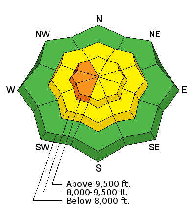
bottom line Areas of CONSIDERABLE danger exist in the backcountry. Human triggered avalanches 1-3' deep are possible. The danger is most pronounced up high on steep westerly aspects due to recent wind drifting...as well as north to easterly facing slopes above 9000'. Continue to put only one person on the slope at a time. Make a plan. Follow it. And get out of the way at the bottom. Remember - safe, excellent powder can be found in the shady sheltered terrain on slopes of 30 degrees in steepness or less as long as nothing steeper is above.
|
 |
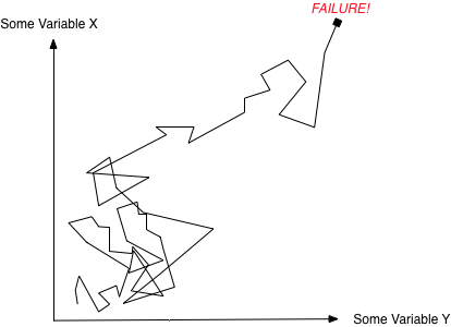
special announcement What is your Level of Acceptable Risk? How did you determine this? Some will center-punch Superior on a CONSIDERABLE danger while others feel happy going to Powder Park everyday. Everyone is different and it's insulting at worst and a waste of time at best to look askance at others who are on either end of the pendulum. It's - how shall we say - inelegant to look upon some as suicidal and others as boring and unfulfilled. Read more about risk and perception in the backcountry with our latest Blog post - Drift into Failure...or, Mathematics and a Few Thoughts on Risk
|
 |
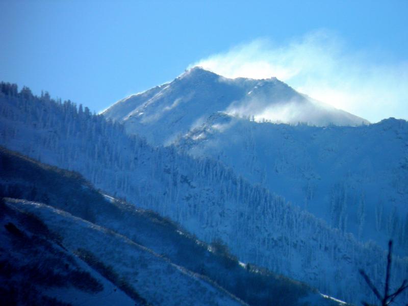
current conditions Happy New Year - The UAC wishes you the best for a safe, healthy, and fulfilling 2015 Skies are clear. Temps along the ridgelines are in the low to mid-teens. Cooler air pooling in the drainages and mountain basins have trailhead temps in the single digits. Winds, blustery from the east and northeast yesterday, are now generally less than 15mph. Along the 11k elevations, they continue to blow 20-25mph with gusts to 40. The open expanses of the alpine suffer wind damage and the southerly aspects will sport a nice zipper crust this morning. But make no mistake - there's plenty of 4-star powder in the sheltered shady terrain. (Photo of wind from Mark White). Note wind blowing east to west.
|
 |
recent activity Most folks that I know avoided the open alpine terrain yesterday - (why go up there and find wind slabs and poor snow quality?)...and instead opted for better and safer options in the mid-elevation glades. Those that couldn't hide from the easterlies b/c they earn a living in the snow and avalanche world reported various 8-15" wind drifts that moved with explosives and slope cuts. |
| type | aspect/elevation | characteristics |
|---|

|
|
LIKELIHOOD
 LIKELY
UNLIKELY
SIZE
 LARGE
SMALL
TREND
 INCREASING DANGER
SAME
DECREASING DANGER
|
|
description
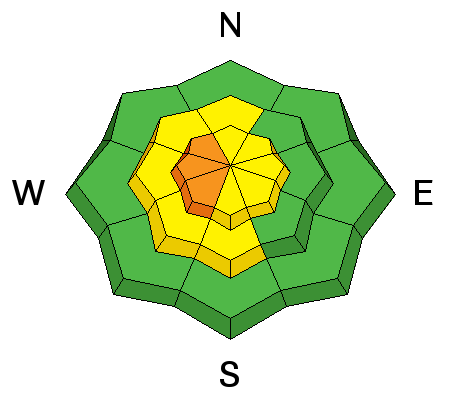
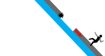
You'll still find sensitive and stubborn wind drifts in exposed terrain today. These will be in odd and unusual places - many cornices and easterly starting zones have been stripped...with fresh wind deposits on the northwest through southwest facing starting zones. Remember the difference between soft and hard slabs - soft slabs you're "in", hard slabs you're "on". Cracking and whumphing are sure-fire clues to instability. With hard wind slabs, though, sometimes you see/feel neither while you inadvertently collapse the thinner part of the lens as the drift breaks above you. See below.
|
| type | aspect/elevation | characteristics |
|---|

|
|
LIKELIHOOD
 LIKELY
UNLIKELY
SIZE
 LARGE
SMALL
TREND
INCREASING DANGER
SAME
DECREASING DANGER
|
|
description
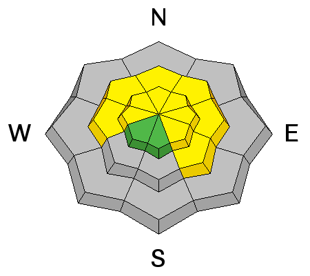
These are Low Probability-High Consequence avalanches. Dangerous. The 1-3' thick "slabs" have gained quite a bit of stiffness and strength over the past few days and triggering these will become increasingly difficult. While we're a few days past our last precipitation loading event, we're only hours since our last wind-loading event. Treat those westerly aspects with care - as they may be just as likely to be problematic as our usual north to east facing slopes. Take a moment and dig down and conduct some snow tests to gain some understanding of the conditions under your feet. Lastly, stack the odds in your favor if you choose to head into known terrain holding a "persistent slab" - does your run end in a terrain trap such as a cliff band, stands of trees, or a steep-walled gulley? Remember these will pull out above you as well - all the rest of them from last week have -
|
 |
weather We'll have mostly sunny skies, light to moderate east to northeast wind, and temps rising to the upper teens at 10,000' and the low-20s at 8000'. The two main synoptic features include a building ridge to the west in the wake of a storm moving through southern Utah and Colorado. We'll be on the downstream side of the ridge, allowing for a weak cold front to move through early Saturday. The January thaw takes place next week with models forecasting temps to near 40F at 10,000' by Wednesday. Happy New Year - pic Jake Hutchinson.
|
| general announcements
Remember your information can save lives. If you see anything we should know about, please participate in the creation of our own community avalanche advisory by submitting snow and avalanche conditions. You can also call us at 801-524-5304, email by clicking HERE, or include #utavy in your tweet or Instagram. If you trigger an avalanche in the backcountry - especially if you are adjacent to a ski area – please call the following teams to alert them to the slide and whether anyone is missing or not. Rescue teams can be exposed to significant hazard when responding to avalanches, and do not want to do so when unneeded. Thanks. Salt Lake and Park City – Alta Central (801-742-2033), Canyons Resort Dispatch (435-615-3322) Snowbasin Resort Dispatch (801-620-1017), Powder Mountain Dispatch (801-745-3772 x 123). Sundance Dispatch (801-223-4150) EMAIL ADVISORY If you would like to get the daily advisory by email you will need to subscribe here. DAWN PATROL Hotline updated daily by 5-530am - 888-999-4019 option 8. Twitter Updates for your mobile phone - DETAILS UDOT canyon closures: LINK TO UDOT, or on Twitter, follow @UDOTavy, @CanyonAlerts or @AltaCentral Utah Avalanche Center mobile app - Get your advisory on your iPhone along with great navigation and rescue tools. Wasatch Powderbird Guides Blog/Itinerary for the Day. Lost or Found something in the backcountry? - http://nolofo.com/ Discount lift tickets are now available at Backcountry.com with more resorts to come soon. Thanks to Ski Utah and the Utah Resorts. All proceeds go towards paying for Utah Avalanche Center avalanche and mountain weather advisories. To those skinning uphill at resorts: it is your responsibility to know the resort policy on uphill travel. You can see the uphill travel policy for each resort here. IMPORTANT: Before skinning or hiking at a resort under new snow conditions, check in with Ski Patrol. Resorts can restrict or cut off access if incompatible with control and grooming operations. Benefit the Utah Avalanche Center when you shop from Backcountry.com or REI: Click this link for Backcountry.com or this link to REI, shop, and they will donate a percent of your purchase price to the UAC. Both offer free shipping (with some conditions) so this costs you nothing! Benefit the Utah Avalanche Center when you buy or sell on ebay - set the Utah Avalanche Center as a favorite non-profit in your ebay account here and click on ebay gives when you buy or sell. You can choose to have your seller fees donated to the UAC, which doesn't cost you a penny. This information does not apply to developed ski areas or highways where avalanche control is normally done. This advisory is from the U.S.D.A. Forest Service, which is solely responsible for its content. This advisory describes general avalanche conditions and local variations always exist. |


.jpg)