| During the month of April, Mark Miller will donate $75 to the charity of your choice (5 to chose from, including the Utah Avalanche Center!) Mark Miller Subaru has raised over $300k in the previous 6 Do Good Feel Good events. More Info here |  |
| During the month of April, Mark Miller will donate $75 to the charity of your choice (5 to chose from, including the Utah Avalanche Center!) Mark Miller Subaru has raised over $300k in the previous 6 Do Good Feel Good events. More Info here | |
| Advisory: Salt Lake Area Mountains | Issued by Evelyn Lees for Saturday - December 27, 2014 - 6:54am |
|---|

|
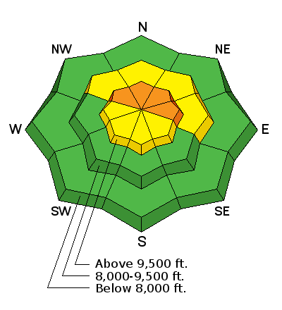
bottom line The avalanche danger is CONSIDERABLE on upper elevation slopes facing northwest through east, where in isolated places, large slides releasing near the ground can still be triggered on slopes of approaching 35 degrees and steeper. Avoid all steep slopes with recent drifts of wind blown snow. Take advantage of the lower avalanche danger on the more southerly facing slopes and excellent riding conditions on the low angle slopes of all aspects.
|
 |
special announcement Wasatch Powderbird Guides is beginning their guiding operations for the season today. For more information, check their Blog/Itinerary , which will be updated daily. |
 |
current conditions Under mostly clear skies, temperatures are in the chilly single digits, both positive and negative. The northwesterly winds are quite light, with most stations averaging around 10 mph. Over the past 24 hours, the highest peaks have averaged in the 15 to 25 mph range at times, with gusts occasionally to 40 mph. Riding conditions are excellent in classic Wasatch powder, though the snowpack is still a bit shallow at the low and mid elevations - fallen trees, shrubs and rocks lurking above and below the surface are a hazard. |
 |
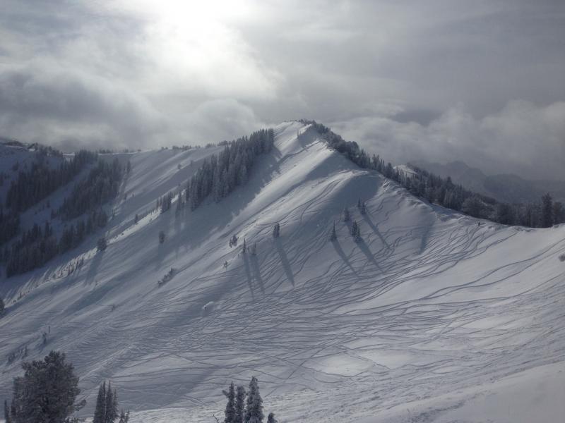
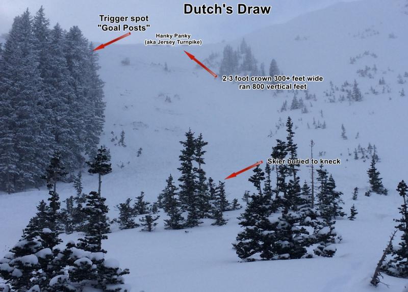
recent activity There were 2 avalanches in east facing Dutch Draw, on the Park City ridge line, in the past 36 hours. The first occurred late afternoon or overnight on the 25th, and it’s unknown if it was remotely triggered or a natural. A skier triggered a 2nd slide yesterday afternoon, 2-3 feet deep, 300 feet wide, failing near the ground. While partially buried, the skier was uninjured. Check out the avalanche list for more information on both slides HERE. For the 3rd day in a row, explosive work at the Salt Lake and Park City area resorts released full depth avalanches. The largest yesterday was in unskied terrain, on a NE facing slope at 10,200’, 3-4’ deep and 250’ wide. Left - Photo of slide in Dutch Draw from the night of the 25th (pc Hutchinson). Right - skier triggered slide from 26th.
|
| type | aspect/elevation | characteristics |
|---|

|
|
LIKELIHOOD
 LIKELY
UNLIKELY
SIZE
 LARGE
SMALL
TREND
 INCREASING DANGER
SAME
DECREASING DANGER
|
|
description
It is a frustrating snow pack – there are weak facets somewhere in the snow pack on almost all aspects and elevations. But the 2 facet layers that have been active in the past week – one mid pack and one at the ground - have been on upper elevation slopes facing northwest through east. While these weak layers are becoming more stubborn and harder to trigger each day, there are still places a person can trigger a deep, large slide. Avoiding steep slopes in upper elevation terrain facing northwest through east is the best way to handle this complex pattern until the facets become dormant again. |
| type | aspect/elevation | characteristics |
|---|

|

|
LIKELIHOOD
LIKELY
UNLIKELY
SIZE
 LARGE
SMALL
TREND
 INCREASING DANGER
SAME
DECREASING DANGER
|
|
description
Yesterday’s late afternoon bump in wind speeds created a few wind drifts along the high ridge lines that could be triggered today. With LOTS of snow available for transport, drifts will continue to build today in upper elevation terrain, even with wind speeds of 15 to 20 mph. Be alert for increased wind speeds where you are traveling - as the snow starts to drift, identify and avoid the denser, cracky, pillowy new wind slabs on steep slopes. |
| type | aspect/elevation | characteristics |
|---|

|

|
LIKELIHOOD
LIKELY
UNLIKELY
SIZE
 LARGE
SMALL
TREND
 INCREASING DANGER
SAME
DECREASING DANGER
|
|
description
After another cold, clear night, the snow will sluff easily today on steep slopes of all aspects. Avoid getting caught or hit by one, as they can pack a punch. |
 |
weather High pressure over the area will bring mostly clear skies and light winds to the mountains today. The northwesterly winds will remain less than 15 mph at most locations, with only the highest peaks averaging close to 30 mph at times. Temperatures will warm to near 20 at 8,000’ and remain in the single digits at 10,000’. Clouds will start increasing this afternoon and tonight, ahead of the next cold storm that could add another foot of light powder Sunday afternoon through Monday. |
| general announcements Remember your information can save lives. If you see anything we should know about, please participate in the creation of our own community avalanche advisory by submitting snow and avalanche conditions. You can also call us at 801-524-5304, email by clicking HERE, or include #utavy in your tweet or Instagram. If you trigger an avalanche in the backcountry - especially if you are adjacent to a ski area – please call the following teams to alert them to the slide and whether anyone is missing or not. Rescue teams can be exposed to significant hazard when responding to avalanches, and do not want to do so when unneeded. Thanks. Salt Lake and Park City – Alta Central (801-742-2033), Canyons Resort Dispatch (435-615-3322) Snowbasin Resort Dispatch (801-620-1017), Powder Mountain Dispatch (801-745-3772 x 123). Sundance Dispatch (801-223-4150) EMAIL ADVISORY If you would like to get the daily advisory by email you will need to subscribe here. DAWN PATROL Hotline updated daily by 5-530am - 888-999-4019 option 8. Twitter Updates for your mobile phone - DETAILS UDOT canyon closures: LINK TO UDOT Utah Avalanche Center mobile app - Get your advisory on your iPhone along with great navigation and rescue tools. Wasatch Powderbird Guides Blog/Itinerary for the Day. Lost or Found something in the backcountry? - http://nolofo.com/ Discount lift tickets are now available at Backcountry.com with more resorts to come soon. Thanks to Ski Utah and the Utah Resorts. All proceeds go towards paying for Utah Avalanche Center avalanche and mountain weather advisories. To those skinning uphill at resorts: it is your responsibility to know the resort policy on uphill travel. You can see the uphill travel policy for each resort here. IMPORTANT: Before skinning or hiking at a resort under new snow conditions, check in with Ski Patrol. Resorts can restrict or cut off access if incompatible with control and grooming operations. Benefit the Utah Avalanche Center when you shop from Backcountry.com or REI: Click this link for Backcountry.com or this link to REI, shop, and they will donate a percent of your purchase price to the UAC. Both offer free shipping (with some conditions) so this costs you nothing! Benefit the Utah Avalanche Center when you buy or sell on ebay - set the Utah Avalanche Center as a favorite non-profit in your ebay account here and click on ebay gives when you buy or sell. You can choose to have your seller fees donated to the UAC, which doesn't cost you a penny. This information does not apply to developed ski areas or highways where avalanche control is normally done. This advisory is from the U.S.D.A. Forest Service, which is solely responsible for its content. This advisory describes general avalanche conditions and local variations always exist |