| During the month of April, Mark Miller will donate $75 to the charity of your choice (5 to chose from, including the Utah Avalanche Center!) Mark Miller Subaru has raised over $300k in the previous 6 Do Good Feel Good events. More Info here |  |
| During the month of April, Mark Miller will donate $75 to the charity of your choice (5 to chose from, including the Utah Avalanche Center!) Mark Miller Subaru has raised over $300k in the previous 6 Do Good Feel Good events. More Info here | |
| Advisory: Salt Lake Area Mountains | Issued by Brett Kobernik for Friday - December 26, 2014 - 6:48am |
|---|

|
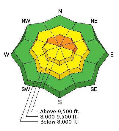
bottom line A pockety CONSIDERABLE avalanche danger remains above 9500 feet on northwest through east facing slopes. Human triggered avalanches are likely in these areas especially with a recent wind load. Keeping slope angles below 35 degrees will greatly decrease your chances for triggering an avalanche.
|
 |
current conditions Very nice storm. Totals along the Park City Ridgeline and upper Big Cottonwood are 7 to 10 inches with around a half inch of water. Upper Little Cottonwood is pushing 20 inches with 8/10ths of an inch of water. The mid portions of the Cottonwoods did really well also pushing 20 inches of low density snow. Temperatures are cold and winds fairly light from a northerly direction. Riding conditions don't get too much better. |
 |
recent activity The new snow was a bit prone to sluffing during the day yesterday. Small natural loose snow avalanches were observed. A more notable slide was in Mineral Fork where a natural loose snow sluff cascaded of a cliff and popped out an old wind slab below the cliffs producing a sizable debris pile. This demonstrates the exact type of issue that's going to pose a threat again today. It ain't green light conditions out there folks! |
| type | aspect/elevation | characteristics |
|---|

|

|
LIKELIHOOD
 LIKELY
UNLIKELY
SIZE
 LARGE
SMALL
TREND
 INCREASING DANGER
SAME
DECREASING DANGER
|
|
description
The human triggered avalanche in Days Fork on Tuesday and the natural in Mineral yesterday demonstrate the type of avalanches you should again anticipate today. They are pockety in nature meaning that you can have a stable slope and then right next door have an unstable slope. This makes assessment difficult which in turn is the reason for the dangerous conditions. It's hard to know just which slopes will avalanche unless you have been keeping a very close eye on a particular slope and know that the old snow has gained enough strength. If you don't know the underlying snow structure of a slope you're about to ride, it's just a roll of the dice. Northwest to east facing slopes above 9000 feet are the most likely spots especially where the snowpack was previously thin from either lack of snow or on paths that have previously avalanched. Most savvy folks I know are proceding with caution and are going to let the snowpack settle and consolidate a bit more before seriously getting after it. |
| type | aspect/elevation | characteristics |
|---|

|
|
LIKELIHOOD
LIKELY
UNLIKELY
SIZE
 LARGE
SMALL
TREND
INCREASING DANGER
SAME
DECREASING DANGER
|
|
description
The new low denstiy loose snow may still be prone to sluffing today although less so than yesterday. Just be mindful that you may start a sluff on the steeper slopes that could entrain a decent amount of snow if it runs far enough. This is a manageable issue by being aware that snow may be following you downhill after diving in. |
 |
weather We'll have partly cloudy to mostly cloudy skies today with ridgetop temperatures only into the low teens. North winds should be fairly well behaved with light speeds and perhaps moderate speed gusts. You may note a slight northeast direction to the wind. We should see continued cold temperatures on Saturday with clearing early then starting to cloud up late ahead of the next storm. We should see snow Sunday into Monday with perhaps a half inch of water weight anticipated. Snow densities should again be low with 5 to 10 inches of fluff possible. |
| general announcements
Remember your information can save lives. If you see anything we should know about, please participate in the creation of our own community avalanche advisory by submitting snow and avalanche conditions. You can also call us at 801-524-5304, email by clicking HERE, or include #utavy in your tweet or Instagram. If you trigger an avalanche in the backcountry - especially if you are adjacent to a ski area – please call the following teams to alert them to the slide and whether anyone is missing or not. Rescue teams can be exposed to significant hazard when responding to avalanches, and do not want to do so when unneeded. Thanks. Salt Lake and Park City – Alta Central (801-742-2033), Canyons Resort Dispatch (435-615-3322) Snowbasin Resort Dispatch (801-620-1017), Powder Mountain Dispatch (801-745-3772 x 123). Sundance Dispatch (801-223-4150) EMAIL ADVISORY If you would like to get the daily advisory by email you will need to subscribe here. DAWN PATROL Hotline updated daily by 5-530am - 888-999-4019 option 8. Twitter Updates for your mobile phone - DETAILS UDOT canyon closures: LINK TO UDOT Utah Avalanche Center mobile app - Get your advisory on your iPhone along with great navigation and rescue tools. Wasatch Powderbird Guides Blog/Itinerary for the Day. Lost or Found something in the backcountry? - http://nolofo.com/ Discount lift tickets are now available at Backcountry.com with more resorts to come soon. Thanks to Ski Utah and the Utah Resorts. All proceeds go towards paying for Utah Avalanche Center avalanche and mountain weather advisories. To those skinning uphill at resorts: it is your responsibility to know the resort policy on uphill travel. You can see the uphill travel policy for each resort here. IMPORTANT: Before skinning or hiking at a resort under new snow conditions, check in with Ski Patrol. Resorts can restrict or cut off access if incompatible with control and grooming operations. Benefit the Utah Avalanche Center when you shop from Backcountry.com or REI: Click this link for Backcountry.com or this link to REI, shop, and they will donate a percent of your purchase price to the UAC. Both offer free shipping (with some conditions) so this costs you nothing! Benefit the Utah Avalanche Center when you buy or sell on ebay - set the Utah Avalanche Center as a favorite non-profit in your ebay account here and click on ebay gives when you buy or sell. You can choose to have your seller fees donated to the UAC, which doesn't cost you a penny. This information does not apply to developed ski areas or highways where avalanche control is normally done. This advisory is from the U.S.D.A. Forest Service, which is solely responsible for its content. This advisory describes general avalanche conditions and local variations always exist. |