| During the month of April, Mark Miller will donate $75 to the charity of your choice (5 to chose from, including the Utah Avalanche Center!) Mark Miller Subaru has raised over $300k in the previous 6 Do Good Feel Good events. More Info here |  |
| During the month of April, Mark Miller will donate $75 to the charity of your choice (5 to chose from, including the Utah Avalanche Center!) Mark Miller Subaru has raised over $300k in the previous 6 Do Good Feel Good events. More Info here | |
| Advisory: Salt Lake Area Mountains | Issued by Drew Hardesty for Thursday - December 25, 2014 - 6:00am |
|---|

|
bottom line We have a CONSIDERABLE avalanche danger in the backcountry that will be most active and pronounced in the morning hours and during periods of high snowfall intensity. Collapsing and shooting cracks are tell-tale signs of instability. You can find safe and world-class face-shots and over-the-hood riding on many low angle slopes today. Have a safe Christmas folks!
|
 |
special announcement The UDOT avalanche control teams in Little Cottonwood Canyon will be conducting avalanche work this morning above the Alta by-pass Road between 7 and 8:00 and intermittent closures are to be expected. They indicated that it seems likely that they will be closing the Hellgate-Superior portion of the Hwy at some point today. In keeping with tradition, here are a couple Christmas holiday gifts for you. Grandma got run over By a Deep Slab
|
 |
current conditions Now this is the classic Wasatch storm that we all know and love - with the timing to boot. The cold front arrived just after midnight and as of 5am most areas are already up to 5-6". It should continue to snow throughout much of the day with a cool foot of snow or more by the time it's all said and done. Temps are in the low teens...and dropping. Winds, while gusty prior to and during frontal passage, are now a more user-friendly 15mph from the west and northwest. |
 |
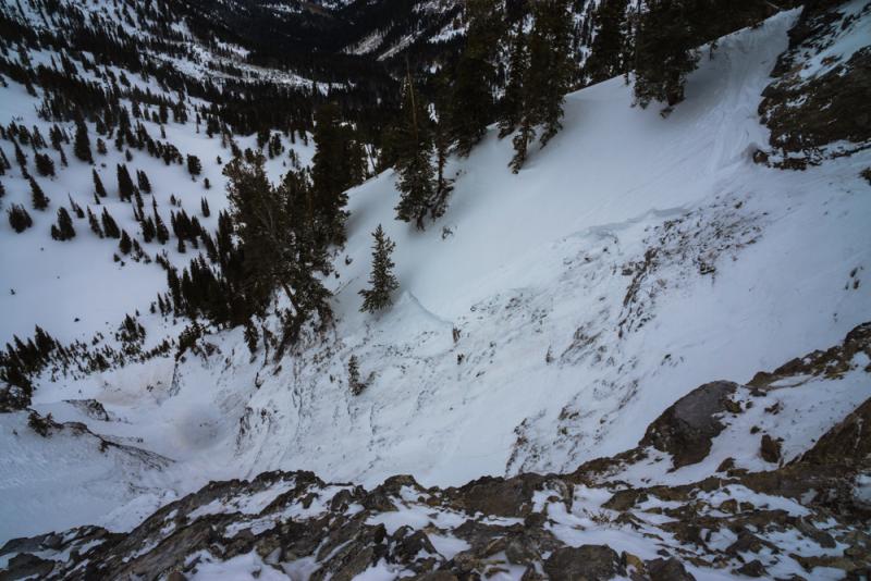
recent activity By now many of you have likely heard of the avalanche accident in the Jaws chute (link to map) in upper Days Fork of Big Cottonwood Canyon. The third skier down the chute triggered and was caught, carried, and fully buried in an avalanche that took what was left of the entire snowpack down with him. The hard slab was up to 2' deep, 100' wide and carried the skier over 800' down through the rocks and trees. He was an experienced backcountry skier in his mid-40s and was efficiently located and recovered by his ski partners, only to find that he had an open fractured lower leg (tib/fib). Hats off -as always - to Wasatch Backcountry Rescue, SL Co Sheriffs Office and LifeFlight for the patient packaging and extraction. Bruce Tremper went up for the investigation yesterday and his thorough report can be found here. Photo below looking down the steep rocky chute of Jaws (note tracks coming in from the right). Photo: Campanellli. Best hopes for a speedy recovery.
|
| type | aspect/elevation | characteristics |
|---|

|
|
LIKELIHOOD
 LIKELY
UNLIKELY
SIZE
 LARGE
SMALL
TREND
 INCREASING DANGER
SAME
DECREASING DANGER
|
|
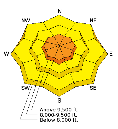
description
As always, the Devil's in the Details. It's not necessarily how much snow fell...it's how much how fast and how recently. In other words, the snow will be most sensitive when it's snowing 1-2"/hour - as it is now. Similarly, there is some speculation that the new snow may not initially bond all that well with the pre-existing snow surface from yesterday - so - Hot Tip - these types of instabilities tend to show their cards pretty well and respond to slope cuts and cornice drops while test slopes, quick hand pits, and previous tracks on the slope are generally good indicators of the current conditions. Click on the 'i' next to the Storm Snow icon and compare this type of avalanche problem with the one below.
|
| type | aspect/elevation | characteristics |
|---|

|
|
LIKELIHOOD
 LIKELY
UNLIKELY
SIZE
LARGE
SMALL
TREND
 INCREASING DANGER
SAME
DECREASING DANGER
|
|
description
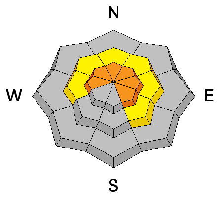
The persistent weaknesses within the snowpack tend to be "re-activated" with each additional loading event...and this is no different. Snow tests and collapsing are still indicating that these buried weaknesses from early to mid-December still haven't gone dormant and the savvy backcountry rider will continue to avoid this terrain or stick to slopes less than 35 degrees in steepness. These may be more active if triggered with a heavier load such as a large cornice or a snowmobile. |
| type | aspect/elevation | characteristics |
|---|

|
|
LIKELIHOOD
LIKELY
UNLIKELY
SIZE
LARGE
SMALL
TREND
INCREASING DANGER
SAME
DECREASING DANGER
|
|
description
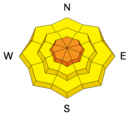
These new snow instabilities will be sitting above some of yesterday/last night's fresh wind slabs that were deposited in high open exposed lee terrain and will be primarily crossloaded on west and easterly facing terrain and directly loaded on the high norths...they haven't settled out yet. Any new snow slide may also dig into these deeper drifts allowing for a more dangerous proposition. These drifts may be soft or hard, allowing you to get way out onto them before they collapse and run. |
 |
weather We should see periods of snow during the day and lingering into tomorrow. Areas favored by a northwest to northerly flow should see the lion's share of the snowfall with amount of 12-16" possible. Winds will continue to veer to the north, northeast and then east as the storm slowly pulls off to the east and should remain less than 20mph. Temps at 10k will plummet to the low single digits, warm a touch on Saturday and drop again as the next storm envelops the area on Sunday. |
| general announcements
Remember your information can save lives. If you see anything we should know about, please participate in the creation of our own community avalanche advisory by submitting snow and avalanche conditions. You can also call us at 801-524-5304, email by clicking HERE, or include #utavy in your tweet or Instagram. If you trigger an avalanche in the backcountry - especially if you are adjacent to a ski area – please call the following teams to alert them to the slide and whether anyone is missing or not. Rescue teams can be exposed to significant hazard when responding to avalanches, and do not want to do so when unneeded. Thanks. Salt Lake and Park City – Alta Central (801-742-2033), Canyons Resort Dispatch (435-615-3322) Snowbasin Resort Dispatch (801-620-1017), Powder Mountain Dispatch (801-745-3772 x 123). Sundance Dispatch (801-223-4150) EMAIL ADVISORY If you would like to get the daily advisory by email you will need to subscribe here. DAWN PATROL Hotline updated daily by 5-530am - 888-999-4019 option 8. Twitter Updates for your mobile phone - DETAILS UDOT canyon closures: LINK TO UDOT Utah Avalanche Center mobile app - Get your advisory on your iPhone along with great navigation and rescue tools. Wasatch Powderbird Guides Blog/Itinerary for the Day. Lost or Found something in the backcountry? - http://nolofo.com/ Discount lift tickets are now available at Backcountry.com with more resorts to come soon. Thanks to Ski Utah and the Utah Resorts. All proceeds go towards paying for Utah Avalanche Center avalanche and mountain weather advisories. To those skinning uphill at resorts: it is your responsibility to know the resort policy on uphill travel. You can see the uphill travel policy for each resort here. IMPORTANT: Before skinning or hiking at a resort under new snow conditions, check in with Ski Patrol. Resorts can restrict or cut off access if incompatible with control and grooming operations. Benefit the Utah Avalanche Center when you shop from Backcountry.com or REI: Click this link for Backcountry.com or this link to REI, shop, and they will donate a percent of your purchase price to the UAC. Both offer free shipping (with some conditions) so this costs you nothing! Benefit the Utah Avalanche Center when you buy or sell on ebay - set the Utah Avalanche Center as a favorite non-profit in your ebay account here and click on ebay gives when you buy or sell. You can choose to have your seller fees donated to the UAC, which doesn't cost you a penny. This information does not apply to developed ski areas or highways where avalanche control is normally done. This advisory is from the U.S.D.A. Forest Service, which is solely responsible for its content. This advisory describes general avalanche conditions and local variations always exist. |