| During the month of April, Mark Miller will donate $75 to the charity of your choice (5 to chose from, including the Utah Avalanche Center!) Mark Miller Subaru has raised over $300k in the previous 6 Do Good Feel Good events. More Info here |  |
| During the month of April, Mark Miller will donate $75 to the charity of your choice (5 to chose from, including the Utah Avalanche Center!) Mark Miller Subaru has raised over $300k in the previous 6 Do Good Feel Good events. More Info here | |
| Advisory: Salt Lake Area Mountains | Issued by Evelyn Lees for Sunday - December 14, 2014 - 6:38am |
|---|

|
bottom line The avalanche danger is MODERATE on steep slopes facing northwest through east at the mid and upper elevations, especially in areas that received the greater snow amounts. Old hard wind slabs hidden beneath the new snow could crack out under the weight of a person, sending you for a ride. Sluffs and new soft wind drifts can also be also triggered, especially on steep, shady slopes. The snow cover is still very shallow and rugged ground cover makes even a short ride in a slide a dangerous proposition.
|
 |
special announcement Join us for a Fireside Chat at Black Diamond, Tuesday, December 16th, at 7pm. Brett Kobernik will review this season's conditions, where we are now and what we have to look forward to. Details here. Tour the Slotterhouse: On Tuesday, Dec 16, at 6 pm Andrew McLean will do a slide show at the Petzl HQ about a recent trip to the Wrangell - St. Ellias National Park and Preserve in AK to ski a spectacular collection of splitter couloirs and schlep around the world's most luxurious glacier camp, putting early British expeditions to shame. Details here. Discount lift tickets are in and for sale - ski a day at the resorts and benefit the Utah Avalanche Center. Tickets for Alta, Brighton, Deer Valley, Solitude, and Snowbasin, Snowbird, and Sundance are in and more tickets are expected shortly. |
 |
current conditions Most areas in the Salt Lake and Park City mountains capped off yesterday’s mix of snow, rain and rime with 1 to 2” of snow overnight, putting storm totals in the 2 to 5” range. The exception was Little Cottonwood, which managed to squeeze another 5” out of the favorable northwest flow overnight, for a storm total of 10” (with up to an inch of water equivalent). Temperatures are in the teens to low 20s this morning, and the northwesterly winds are very light, averaging less then 10 mph at most stations. A few of the highest peaks are averaging 15 to 20 mph, gusting in the 30s. |
 |
recent activity No slab avalanches were reported from the backcountry yesterday, though sluffing was occurring on some very steep, northerly facing slopes at upper elevations. Two hard slab avalanches were triggered on upper elevation northerly facing slopes in the Salt Lake area mountains– by an explosive and a skier. These were deeper pockets about a foot thick. |
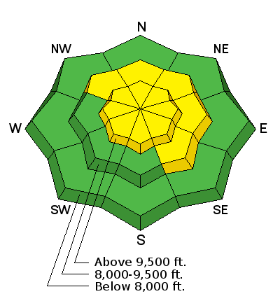
| type | aspect/elevation | characteristics |
|---|

|
|
LIKELIHOOD
 LIKELY
UNLIKELY
SIZE
 LARGE
SMALL
TREND
 INCREASING DANGER
SAME
DECREASING DANGER
|
|
description
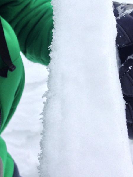
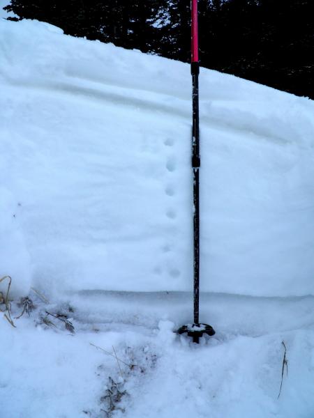
The buried pencil hard wind slabs sitting on sugary facets are still the main concern, and are most likely to be triggered on steep slopes that received the most snow. These hard slabs on facets are tricky because slides can be remotely triggered from a distance, or the snow can seem supportable and then break out above you. This is further complicated by their scattered, pockety nature – it’s hard to know when you are going to stumble on to one. They are most widespread on mid and upper elevation, northerly through easterly facing slopes. In isolated areas, one of these small slides could step down, triggering a larger slide on a deeper weak layer. Left - hard slab with surface hoar and facets stuck on bottom (left) - (pc Lees). Right - snowpack layering with thin hard slab in upper portion, buried beneath the few inches of new snow. A deeper snowpack area where the old facets are moist. (pc White).
|
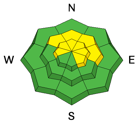
| type | aspect/elevation | characteristics |
|---|

|
|
LIKELIHOOD
LIKELY
UNLIKELY
SIZE
LARGE
SMALL
TREND
 INCREASING DANGER
SAME
DECREASING DANGER
|
|
description
Again, the focus is on the upper elevations that received the most new snow – up to 10”. On steep slopes, especially those facing the north half of the compass, new snow sluffs and shallow soft slabs can be triggered. In addition, avoid new drifts anywhere along the higher ridges where the winds have blown the snow around. |
 |
weather This morning’s intermittent snow showers will taper off as the storm moves out of the area, with minor accumulations of another inch or two of snow possible. In most terrain, the northwesterly winds will remain less than 10 mph throughout the day, with only the highest peaks occasional gusting to 30 mph. Temperatures today remain in the low to mid 20s at 8,000’ and the low teens at 10,000’. An unsettled week ahead will bring periods of clouds and occasional light snow Monday night through Thursday. |
| general announcements Remember your information can save lives. If you see anything we should know about, please participate in the creation of our own community avalanche advisory by submitting snow and avalanche conditions. You can also call us at 801-524-5304, email by clicking HERE, or include #utavy in your tweet or Instagram. If you trigger an avalanche in the backcountry - especially if you are adjacent to a ski area – please call the following teams to alert them to the slide and whether anyone is missing or not. Rescue teams can be exposed to significant hazard when responding to avalanches, and do not want to do so when unneeded. Thanks. Salt Lake and Park City – Alta Central (801-742-2033), Canyons Resort Dispatch (435-615-3322) Snowbasin Resort Dispatch (801-620-1017), Powder Mountain Dispatch (801-745-3772 x 123). Sundance Dispatch (801-223-4150) EMAIL ADVISORY If you would like to get the daily advisory by email you will need to subscribe here. DAWN PATROL Hotline updated daily by 5-530am - 888-999-4019 option 8. Twitter Updates for your mobile phone - DETAILS UDOT canyon closures: LINK TO UDOT Utah Avalanche Center mobile app - Get your advisory on your iPhone along with great navigation and rescue tools. Wasatch Powderbird Guides Blog/Itinerary for the Day. Lost or Found something in the backcountry? - http://nolofo.com/ Discount lift tickets are now available at Backcountry.com with more resorts to come soon. Thanks to Ski Utah and the Utah Resorts. All proceeds go towards paying for Utah Avalanche Center avalanche and mountain weather advisories. To those skinning uphill at resorts: it is your responsibility to know the resort policy on uphill travel. You can see the uphill travel policy for each resort here. IMPORTANT: Before skinning or hiking at a resort under new snow conditions, check in with Ski Patrol. Resorts can restrict or cut off access if incompatible with control and grooming operations. Benefit the Utah Avalanche Center when you shop from Backcountry.com or REI: Click this link for Backcountry.com or this link to REI, shop, and they will donate a percent of your purchase price to the UAC. Both offer free shipping (with some conditions) so this costs you nothing! Benefit the Utah Avalanche Center when you buy or sell on ebay - set the Utah Avalanche Center as a favorite non-profit in your ebay account here and click on ebay gives when you buy or sell. You can choose to have your seller fees donated to the UAC, which doesn't cost you a penny. This information does not apply to developed ski areas or highways where avalanche control is normally done. This advisory is from the U.S.D.A. Forest Service, which is solely responsible for its content. This advisory describes general avalanche conditions and local variations always exist. |