
| During the month of April, Mark Miller will donate $75 to the charity of your choice (5 to chose from, including the Utah Avalanche Center!) Mark Miller Subaru has raised over $300k in the previous 6 Do Good Feel Good events. More Info here |  |
| During the month of April, Mark Miller will donate $75 to the charity of your choice (5 to chose from, including the Utah Avalanche Center!) Mark Miller Subaru has raised over $300k in the previous 6 Do Good Feel Good events. More Info here | |
| Advisory: Salt Lake Area Mountains | Issued by Evelyn Lees for Sunday - November 30, 2014 - 6:47am |
|---|


|
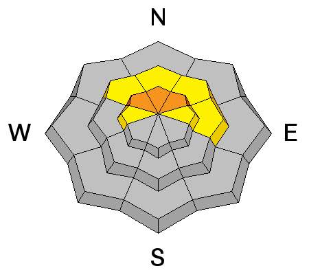
bottom line The avalanche danger is CONSIDERABLE - you can still trigger a slide breaking to the ground. Avoid the steep, upper elevation slopes facing northwest through north through northeast, where 17 backcountry slides have been triggered in the Park City and Salt Lake mountains in just the past week. Choose gentle slopes, less steep than about 30 degrees, with nothing steep above. Also avoid any fresh drifts of wind-blown snow.
|
 |
special announcement On December 4, Powderwhore Productions will be bringing Some Thing Else to Park City. A fundraising raffle will be held to benefit the Utah Avalanche Center. Details here. |
 |
current conditions A weak cold front will bring light snow, cooling temperatures and decreasing wind speeds to the mountains today. Temperatures are currently in the mid 30’s to upper 20s and dropping; the winds are shifting to a more westerly direction, and have decreased into the 10 to 15 mph range, with the high peaks averaging 25 to 35. Soft snow is hard to find among the hard wind slabs and sun crusts, but mid and upper elevation, wind sheltered, northerly facing slopes are your best chance. |
 |
recent activity A slide was triggered remotely from a distance yesterday in the northwest facing Birthday Chutes of Little Cottonwood Canyon – about 2.5’ deep, 60’ wide, and far running, scooping up all the snow in its path. It was at 10,500’ and failed on faceted snow on the ground. Observation posted HERE. |
| type | aspect/elevation | characteristics |
|---|

|
|
LIKELIHOOD
 LIKELY
UNLIKELY
SIZE
 LARGE
SMALL
TREND
 INCREASING DANGER
SAME
DECREASING DANGER
|
|
description
The November facets sitting on the ground continue to produce avalanches. There is now dense slab sitting on these facets, and slides to the ground can still be triggered from a distance and on slope. All you can do is avoid steep upper elevation slopes facing northwest, north and northeast. Around this core of CONSIDERABLE danger where all the recent slides have been triggered, the avalanche danger is MODERATE. As the slab becomes harder, slides will develop the ability to pull onto lower angle terrain. To see where slides have been triggered by elevation and aspect, Kobernik created a “make your own avalanche rose” HERE – just choose your dates. |
| type | aspect/elevation | characteristics |
|---|

|
|
LIKELIHOOD
LIKELY
UNLIKELY
SIZE
 LARGE
SMALL
TREND
 INCREASING DANGER
SAME
DECREASING DANGER
|
|
description
A few other avalanche problems to be aware of in all terrain:
|
 |
weather There will be periods of light snow today through the night as a weak cold front stalls over northern Utah. 3 to 6” of new snow is possible. 10,000’ temperatures will be in the low 20s, and 8,000’ temperatures in the mid-30s. The rain-snow line will be around 6,000’. Winds will remain from the west southwest, with averages in the 5 to 15 mph range. Wind speeds across the highest ridgelines will occasionally average 35 mph, and gust into the 40s. There will be a break on Monday, followed by another warm storm Tuesday night into Wednesday. |
| general announcements Remember your information can save lives. If you see anything we should know about, please participate in the creation of our own community avalanche advisory by submitting snow and avalanche conditions. You can also call us at 801-524-5304, email by clicking HERE, or include #utavy in your tweet or Instagram. If you trigger an avalanche in the backcountry - especially if you are adjacent to a ski area – please call the following teams to alert them to the slide and whether anyone is missing or not. Rescue teams can be exposed to significant hazard when responding to avalanches, and do not want to do so when unneeded. Thanks. Salt Lake and Park City – Alta Central (801-742-2033), Canyons Resort Dispatch (435-615-3322) Snowbasin Resort Dispatch (801-620-1017), Powder Mountain Dispatch (801-745-3772 x 123). Sundance Dispatch (801-223-4150) EMAIL ADVISORY If you would like to get the daily advisory by email you will need to subscribe here. DAWN PATROL Hotline updated daily by 5-530am - 888-999-4019 option 8. Twitter Updates for your mobile phone - DETAILS UDOT canyon closures: LINK TO UDOT Utah Avalanche Center mobile app - Get your advisory on your iPhone along with great navigation and rescue tools. Wasatch Powderbird Guides Blog/Itinerary for the Day. Lost or Found something in the backcountry? - http://nolofo.com/ Discount lift tickets will soon be available at Backcountry.com - Thanks to Ski Utah and the Utah Resorts. All proceeds go towards paying for Utah Avalanche Center avalanche and mountain weather advisories. To those skinning uphill at resorts: it is your responsibility to know the resort policy on uphill travel. You can see the uphill travel policy for each resort here. IMPORTANT: Before skinning or hiking at a resort under new snow conditions, check in with Ski Patrol. Resorts can restrict or cut off access if incompatible with control and grooming operations. Benefit the Utah Avalanche Center when you shop from Backcountry.com or REI: Click this link for Backcountry.com or this link to REI, shop, and they will donate a percent of your purchase price to the UAC. Both offer free shipping (with some conditions) so this costs you nothing! Benefit the Utah Avalanche Center when you buy or sell on ebay - set the Utah Avalanche Center as a favorite non-profit in your ebay account here and click on ebay gives when you buy or sell. You can choose to have your seller fees donated to the UAC, which doesn't cost you a penny. This information does not apply to developed ski areas or highways where avalanche control is normally done. This advisory is from the U.S.D.A. Forest Service, which is solely responsible for its content. This advisory describes general avalanche conditions and local variations always exist. |


