
| During the month of April, Mark Miller will donate $75 to the charity of your choice (5 to chose from, including the Utah Avalanche Center!) Mark Miller Subaru has raised over $300k in the previous 6 Do Good Feel Good events. More Info here |  |
| During the month of April, Mark Miller will donate $75 to the charity of your choice (5 to chose from, including the Utah Avalanche Center!) Mark Miller Subaru has raised over $300k in the previous 6 Do Good Feel Good events. More Info here | |
| Advisory: Salt Lake Area Mountains | Issued by Brett Kobernik for Monday - November 17, 2014 - 7:03am |
|---|

|
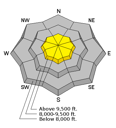
bottom line There is a MODERATE avalanche danger today on slopes of 35 degrees and steeper above around 9500 feet that face northwest, north and northeast. Unfortunately, these are the exact slopes we want to get onto because they hold the most snow right now. Let them be for a bit. A ride through rocks, trees and stumps would be quite unpleasant.
|
 |
special announcement WE ARE ISSUING INTERMITTENT ADVISORIES. THE NEXT ADVISORY WILL BE LATER THIS WEEK AS WEATHER CONDITIONS WARRANT. |
 |
current conditions Sunday brought clear skies, cold temperatures and a pesky north wind that was transporting snow along the higher ridges. It did some damage to the riding conditions on northerly facing aspects. The north winds slowed slightly since yesterday but are still blowing along the upper ridges. It's clear this morning and temperatures are in the low teens with a few single digit readings in the bottoms of the drainages - perfect weather for the new snow to start faceting and become weak. |
 |
recent activity No new avalanches were reported on Sunday. I did note one small wind slab that released onto a southerly slope near Point Supreme from a small cornice fall due to the north winds loading southerly slopes. Someone may have stomped on the cornice to get it to release. The more impressive avalanches were from the avalanche cycle that occurred on Saturday. CLICK HERE to read the details of the avalanche cycle including how the weak layer and crust formed prior to the event. |
| type | aspect/elevation | characteristics |
|---|

|
|
LIKELIHOOD
 LIKELY
UNLIKELY
SIZE
 LARGE
SMALL
TREND
 INCREASING DANGER
SAME
DECREASING DANGER
|
|
description
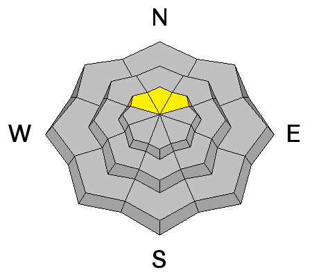
The persistent weak layer of facets still could produce a large slab avalanche today. While things have calmed down and are adjusting, you won't find me poking around say, the north slope of Sunset Peak today. I've learned to not screw around on slopes that where a persistent weak layer is present. We will need to monitor this persistent weak layer and see how the upcoming weather will effect it. If we start seeing consistent snow storms, it could heal and become a thing of the past. If we see a prolonged dry period, all of the snow could continue to deteriorate into faceted grains like the start of last season. |
| type | aspect/elevation | characteristics |
|---|

|
|
LIKELIHOOD
LIKELY
UNLIKELY
SIZE
 LARGE
SMALL
TREND
INCREASING DANGER
SAME
DECREASING DANGER
|
|
description
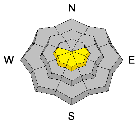
If you try hard, you may be able to get a fresh wind slab to release today also. Watch southerly facing slopes just off the higher ridges. |
 |
weather Today we'll see mostly clear skies with temeratures a bit warmer than yesterday and moderate speed northerly winds. Look for the temperatures to get into the low 20s at 8000' and a bit cooler along the ridgetops. It'll be clear and cold again tonight - more perfect faceting weather. Tuesday looks clear with warmer temperatures yet than today. For the long term, the weather looks somewhat hopeful for conditions to combat early season faceting. It looks as if there will be a few small storms moving through later in the week with a more promising storm for the weekend. If we can continue to change up the snow surface with new snow at regular intervals, it will dramatically help combat the early season faceting. |
| general announcements Remember your information can save lives. If you see anything we should know about, please participate in the creation of our own community avalanche advisory by submitting snow and avalanche conditions. You can also call us at 801-524-5304, email by clicking HERE, or include #utavy in your tweet or Instagram. If you trigger an avalanche in the backcountry - especially if you are adjacent to a ski area – please call the following teams to alert them to the slide and whether anyone is missing or not. Rescue teams can be exposed to significant hazard when responding to avalanches, and do not want to do so when unneeded. Thanks. Salt Lake and Park City – Alta Central (801-742-2033), Canyons Resort Dispatch (435-615-3322) Snowbasin Resort Dispatch (801-620-1017), Powder Mountain Dispatch (801-745-3772 x 123). Sundance Dispatch (801-223-4150) EMAIL ADVISORY If you would like to get the daily advisory by email you will need to subscribe here. DAWN PATROL Hotline updated daily by 5-530am - 888-999-4019 option 8. Twitter Updates for your mobile phone - DETAILS UDOT canyon closures: LINK TO UDOT Utah Avalanche Center mobile app - Get your advisory on your iPhone along with great navigation and rescue tools. Wasatch Powderbird Guides Blog/Itinerary for the Day. Lost or Found something in the backcountry? - http://nolofo.com/ Discount lift tickets will soon be available at Backcountry.com - Thanks to Ski Utah and the Utah Resorts. All proceeds go towards paying for Utah Avalanche Center avalanche and mountain weather advisories. To those skinning uphill at resorts: it is your responsibility to know the resort policy on uphill travel. Some allow uphill travel and have guidelines, some don't. Contact the Ski Patrol at each resort for details. IMPORTANT: Before skinning at a resort under new snow conditions, check in with Ski Patrol. Resorts can restrict or cut off access if incompatible with control and grooming operations. Benefit the Utah Avalanche Center when you shop from Backcountry.com or REI: Click this link for Backcountry.com or this link to REI, shop, and they will donate a percent of your purchase price to the UAC. Both offer free shipping (with some conditions) so this costs you nothing! Benefit the Utah Avalanche Center when you buy or sell on ebay - set the Utah Avalanche Center as a favorite non-profit in your ebay account here and click on ebay gives when you buy or sell. You can choose to have your seller fees donated to the UAC, which doesn't cost you a penny. This information does not apply to developed ski areas or highways where avalanche control is normally done. This advisory is from the U.S.D.A. Forest Service, which is solely responsible for its content. This advisory describes general avalanche conditions and local variations always exist. |


