| During the month of April, Mark Miller will donate $75 to the charity of your choice (5 to chose from, including the Utah Avalanche Center!) Mark Miller Subaru has raised over $300k in the previous 6 Do Good Feel Good events. More Info here |  |
| During the month of April, Mark Miller will donate $75 to the charity of your choice (5 to chose from, including the Utah Avalanche Center!) Mark Miller Subaru has raised over $300k in the previous 6 Do Good Feel Good events. More Info here | |
| Advisory: Salt Lake Area Mountains | Issued by Evelyn Lees for Sunday - November 16, 2014 - 6:36am |
|---|

|
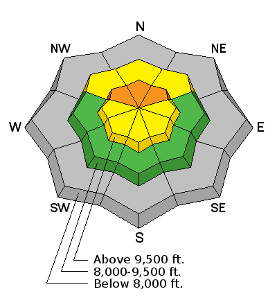
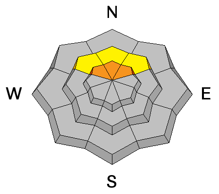
bottom line The avalanche danger is CONSIDERABLE on northwest, north and northeasterly facing slopes above about 9500’. AVOID travel on and below these slopes. Small to large avalanches can be triggered, failing near the ground. These slides can be triggered from a distance and from below. There is also a MODERATE danger of triggering a wind drift on steep slopes of any aspect. It is still a very shallow snowpack, and you could be injured by hitting rocks and stumps. Also, none of the Utah mountain resorts are open for the season so you must treat the snow as a backcountry snowpack.
|
 |
special announcement Alta, Snowbird, Brighton and Solitude resorts are closed to uphill traffic this weekend and until their planned opening date next Friday. To those skinning uphill at other resorts: it is your responsibility to know the resort policy on uphill travel. Some allow uphill travel - some don't. Contact the Ski Patrol at each resort for details. Powder Magazine is publishing an online video series on avalanche accidents, called The Human Factor. It features a number of avalanche experts, including Utah Avalanche Center Director, Bruce Tremper. They will publish a new chapter each Tuesday for the next few weeks. Here is the link: http://www.powder.com/human-factor/ |
 |
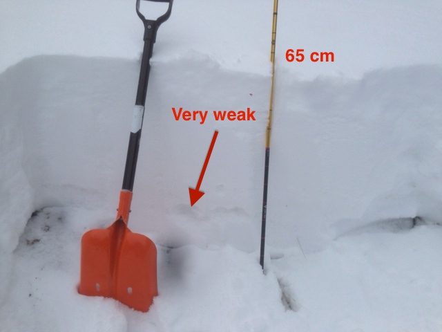
current conditions It’s verrrry cold this morning, with most mountain temperatures just above or below zero. The strong northwesterly wind finally dropped off yesterday evening, and speeds are currently in the 10 to 20 mph range, with gusts 25 mph. This wind will make it feel more like negative 15 or 20. Storm totals ended up with 10 to 16 inches in Little Cottonwood, up to about a foot in Big Cottonwood, 7 to 14” in the Ogden area mountains, and about 6”in Provo. Strong winds during the storm certainty created larger drifts and uneven loading. Total snow on the ground is still skimpy – the upper elevation, shady slopes of Little Cottonwood have about 20”, elsewhere 6 to 14 inches is the average depth. |
 |
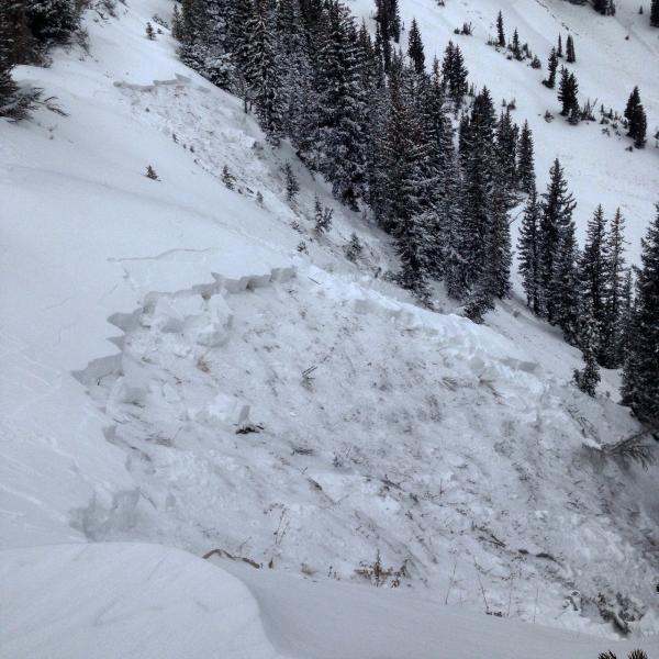
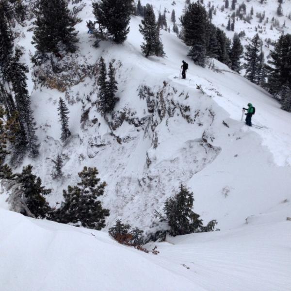
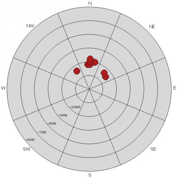
recent activity I definitely under-forecast the avalanche danger yesterday. About 5 slides 20-60' wide range were triggered, but the standouts were 3 slides 200' to 800' wide, 2 in upper Silver Fork, 1 in Pioneer Bowl. All these slides were failing near the ground on the shallow layer of sugary, faceted snow, and were on northerly facing slopes above about 10,000. Most were triggered remotely, but one person went for a short ride in Gun Sight notch. Check out all the details on our Observation Page. Left photo - Bo Torrey, Silver Fork Right photo - Cody Huges Silver Fork
Catherine's area - Toddeo |
| type | aspect/elevation | characteristics |
|---|

|
|
LIKELIHOOD
 LIKELY
UNLIKELY
SIZE
 LARGE
SMALL
TREND
 INCREASING DANGER
SAME
DECREASING DANGER
|
|
description
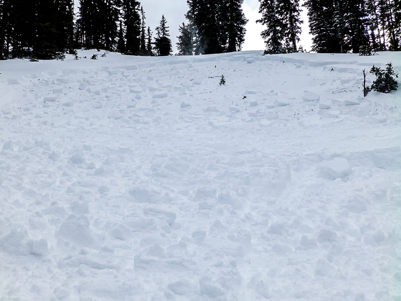
The ability for the shallow layer of facets to connect so widely increases the avalanche danger significantly. Large, wide avalanches can still be triggered today, both on the slope and remotely from a distance – above, from below or to the side. Many of the steep, northerly facing slopes have not slid yet and should be avoided. The faceted weak layer is most widespread in the Cottonwoods. If you do get caught in a slide, even a small one, it could be a rough, nasty ride, being dragged along the ground and through rocks. Here is the set up - Slab on weak facets (PC Trent Meisenheimer)
The Avalanche Rose below shows where yesterday’s slides occurred by aspect and elevation
|
| type | aspect/elevation | characteristics |
|---|

|
|
LIKELIHOOD
 LIKELY
UNLIKELY
SIZE
 LARGE
SMALL
TREND
 INCREASING DANGER
SAME
DECREASING DANGER
|
|
description
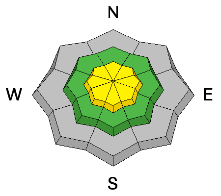
A secondary problem is the wind drifts that formed yesterday on mid and upper elevation slopes. These could crack out beneath the weight of a person. Avoid any steep, wind drifted slope, no matter the aspect. Again, even a short ride in an avalanche could result in bumping along the ground, hitting rocks. |
 |
weather There will be clear skies and very cold temperatures today. Highs will only be in the single digits and teens. The northerly winds may pick up a bit across the high ridges, with averages to 30 mph, and gusts to 40. Speeds in the mid elevation terrain should average below 15 mph. Temperatures will drop back down into the single digits tonight, and warm into the low 20s on Monday. A slow warming trend Monday through Wednesday will hopefully be followed by a few weak disturbances near the end of the week. |
| general announcements Remember your information can save lives. If you see anything we should know about, please participate in the creation of our own community avalanche advisory by submitting snow and avalanche conditions. You can also call us at 801-524-5304, email by clicking HERE, or include #utavy in your tweet or Instagram. If you trigger an avalanche in the backcountry - especially if you are adjacent to a ski area – please call the following teams to alert them to the slide and whether anyone is missing or not. Rescue teams can be exposed to significant hazard when responding to avalanches, and do not want to do so when unneeded. Thanks. Salt Lake and Park City – Alta Central (801-742-2033), Canyons Resort Dispatch (435-615-3322) Snowbasin Resort Dispatch (801-620-1017), Powder Mountain Dispatch (801-745-3772 x 123). Sundance Dispatch (801-223-4150) EMAIL ADVISORY If you would like to get the daily advisory by email you will need to subscribe here. DAWN PATROL Hotline updated daily by 5-530am - 888-999-4019 option 8. Twitter Updates for your mobile phone - DETAILS UDOT canyon closures: LINK TO UDOT Utah Avalanche Center mobile app - Get your advisory on your iPhone along with great navigation and rescue tools. Wasatch Powderbird Guides Blog/Itinerary for the Day. Lost or Found something in the backcountry? - http://nolofo.com/ Discount lift tickets will soon be available at Backcountry.com - Thanks to Ski Utah and the Utah Resorts. All proceeds go towards paying for Utah Avalanche Center avalanche and mountain weather advisories. To those skinning uphill at resorts: it is your responsibility to know the resort policy on uphill travel. Some allow uphill travel and have guidelines, some don't. Contact the Ski Patrol at each resort for details. IMPORTANT: Before skinning at a resort under new snow conditions, check in with Ski Patrol. Resorts can restrict or cut off access if incompatible with control and grooming operations. Benefit the Utah Avalanche Center when you shop from Backcountry.com or REI: Click this link for Backcountry.com or this link to REI, shop, and they will donate a percent of your purchase price to the UAC. Both offer free shipping (with some conditions) so this costs you nothing! Benefit the Utah Avalanche Center when you buy or sell on ebay - set the Utah Avalanche Center as a favorite non-profit in your ebay account here and click on ebay gives when you buy or sell. You can choose to have your seller fees donated to the UAC, which doesn't cost you a penny. This information does not apply to developed ski areas or highways where avalanche control is normally done. This advisory is from the U.S.D.A. Forest Service, which is solely responsible for its content. This advisory describes general avalanche conditions and local variations always exist. |