| During the month of April, Mark Miller will donate $75 to the charity of your choice (5 to chose from, including the Utah Avalanche Center!) Mark Miller Subaru has raised over $300k in the previous 6 Do Good Feel Good events. More Info here |  |
| During the month of April, Mark Miller will donate $75 to the charity of your choice (5 to chose from, including the Utah Avalanche Center!) Mark Miller Subaru has raised over $300k in the previous 6 Do Good Feel Good events. More Info here | |
| Advisory: Salt Lake Area Mountains | Issued by Bruce Tremper for Wednesday - April 30, 2014 - 6:36am |
|---|


|
bottom line Moderate danger today for lingering wind slabs in upper elevation, wind exposed terrain and also Moderate danger today for wet slides on steep, sun exposed slopes as they become damp with daytime heating by the sun.
|
 |
special announcement I have been issuing advisories through this storm but today will be the last avalanche advisory for the season. I will put on an end-of-season message on May 1st. I will still publish your observations so keep them coming if you are getting out in the backcountry. |
 |
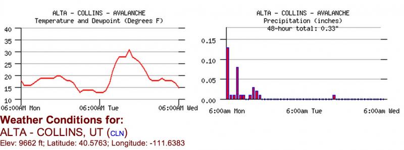
current conditions Yesterday, despite the first day of sun, the moderate winds from the northwest and cold temperatures kept the snow surface from getting too warm. You can still find lots of great, settled powder from the 2 feet of snow that fell during the storm in the Cottonwoods last weekend through Monday. The fairly stiff wind from the northwest continued to create some wind affected snow along the upper elevation ridges. This morning, the temperatures rose to 20 degrees at 8,000' and 15 degrees at 9,500'. Wind is quite light 5-10 from the northwest. Remember, you can always check current conditions for yourself at the National Weather Service Snow Page.
This is a 2-day graph with the present time on the right of each graph.
|
 |
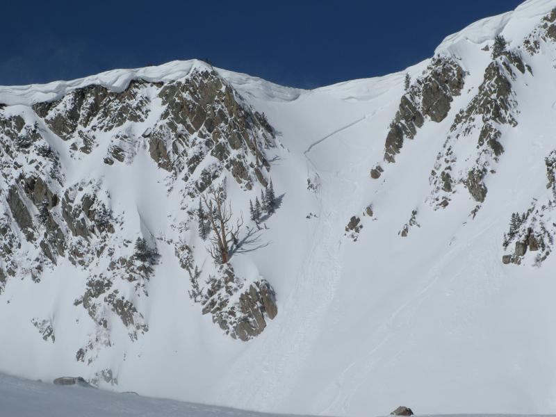
recent activity In contrast to the flurry of avalanche activity on Monday, yesterday skiers triggered only a couple of wind slabs; Skiers triggered a wind slab while descending from the Pfeifferhorn into the upper cirque of Red Pine and one was caught. They posted a great write up and photos. It was about 1' deep and 150' wide, 10,500' NE facing. Another skier triggered a wind slab on a steep slope in Wolverine Cirque but apparently escaped without being caught. 1' x 40', 10,500', NE facing.
Upper Red Pine, one skier caught.
Wolverine Cirque |
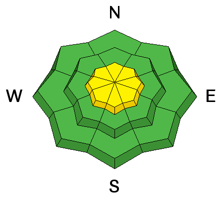
| type | aspect/elevation | characteristics |
|---|

|
|
LIKELIHOOD
 LIKELY
UNLIKELY
SIZE
 LARGE
SMALL
TREND
 INCREASING DANGER
SAME
DECREASING DANGER
|
|
description
I have not been using danger ratings these past days because of the extremely variable conditions but apparently a lot of people think we are not issuing advisories because the map is not lit up with a color. So hey, it's the last forecast of the season so I'll go for the gusto. Lingering wind slabs still exist mostly in upper elevation, wind exposed terrain. Because graupel makes up much of the new snow, instabilities tend to linger longer than regular new snow. Plus, the very cold temperatures preserve the weak layers. So continue to be cautious of steep slopes with recent wind deposits, which usually feel slabby and look smooth and rounded.
|
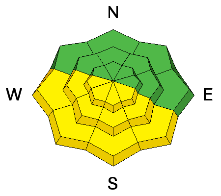
| type | aspect/elevation | characteristics |
|---|

|
|
LIKELIHOOD
LIKELY
UNLIKELY
SIZE
LARGE
SMALL
TREND
 INCREASING DANGER
SAME
DECREASING DANGER
|
|
description
Luckily, we have a slow warming, which I"m hoping will ease us into stable snow without too much wet activity. But today we have light wind and strong sun, which will likely turn the snow on the southerly aspects into mashed potatoes. You should stay off of, and out from underneath, steep slopes when they are getting damp or wet from strong sun or warmer temperatures. The new snow will usually produce roller balls first and then point-release sluffs as it warms even more. |
 |
weather We have sunny skies forecast for the rest of the week and a slow warming trend. Today the ridge top wind should remain light from the northwest and west 5-10 mph. 8,000' temperatures should get into the 40's and into the 30's along the ridge tops. For Thursday and Friday, ridge top wind will blow stronger from the southwest and slowly warm. Be sure to monitor the latest weather conditions before heading out. Here are a few of my favorite sources: Cottonwood Canyons Forecast from the National Weather Service |
| general announcements Remember your information can save lives. If you see anything we should know about, please participate in the creation of our own community avalanche advisory by submitting snow and avalanche conditions. You can also call us at 801-524-5304 or 800-662-4140, email by clicking HERE, or include #utavy in your tweet or Instagram. If you trigger an avalanche in the backcountry - especially if you are adjacent to a ski area – please call the following teams to alert them to the slide and whether anyone is missing or not. Rescue teams can be exposed to significant hazard when responding to avalanches, and do not want to do so when unneeded. Thanks. Salt Lake and Park City – Alta Central (801-742-2033), Canyons Resort Dispatch (435-615-3322) EMAIL ADVISORY We have switched to a new SLC email advisory system. If you would like to get the daily advisory by email, or if you have been getting the advisory by email since the beginning of the season and wish to continue, you will need to subscribe here. Twitter Updates for your mobile phone - DETAILS UDOT canyon closures: LINK TO UDOT Utah Avalanche Center mobile app - Get your advisory on your iPhone along with great navigation and rescue tools.uned. Lost or Found something in the backcountry? - http://nolofo.com/ To those skinning uphill at resorts: it is your responsibility to know the resort policy on uphill travel. Some allow uphill travel and have guidelines, some don't. Contact the Ski Patrol at each resort for details. IMPORTANT: Before skinning at a resort under new snow conditions, check in with Ski Patrol. Resorts can restrict or cut off access if incompatible with control and grooming operations. Benefit the Utah Avalanche Center when you shop from Backcountry.com or REI: Click this link for Backcountry.com or this link to REI, shop, and they will donate a percent of your purchase price to the UAC. Both offer free shipping (with some conditions) so this costs you nothing! Benefit the Utah Avalanche Center when you buy or sell on ebay - set the Utah Avalanche Center as a favorite non-profit in your ebay account here and click on ebay gives when you buy or sell. You can choose to have your seller fees donated to the UAC, which doesn't cost you a penny. This information does not apply to developed ski areas or highways where avalanche control is normally done. This advisory is from the U.S.D.A. Forest Service, which is solely responsible for its content. This advisory describes general avalanche conditions and local variations always exist. |