| During the month of April, Mark Miller will donate $75 to the charity of your choice (5 to chose from, including the Utah Avalanche Center!) Mark Miller Subaru has raised over $300k in the previous 6 Do Good Feel Good events. More Info here |  |
| During the month of April, Mark Miller will donate $75 to the charity of your choice (5 to chose from, including the Utah Avalanche Center!) Mark Miller Subaru has raised over $300k in the previous 6 Do Good Feel Good events. More Info here | |
| Advisory: Salt Lake Area Mountains | Issued by Bruce Tremper for Tuesday - April 29, 2014 - 6:58am |
|---|


|
bottom line Expect lingering wind slabs and storm slabs today in steep terrain. Continually test the new snow as you travel and jump on small, test slopes to see how they respond. Second, stay off of, and out from underneath, steep sun exposed slopes as they heat up in the sun, especially in the heat of the afternoon.
|
 |
special announcement We have gone to intermittent avalanche advisory updates for the rest of April. With the expected weekend storm, we will likely update sometime during the weekend, probably Saturday night or Sunday morning. We are not publishing danger ratings because we don't have very good information this time of year. Plus spring avalanche conditions depend directly on the weather, which is inherently very unpredictable in spring. We are still publishing observations so keep them coming if you are getting out in the backcountry! |
 |
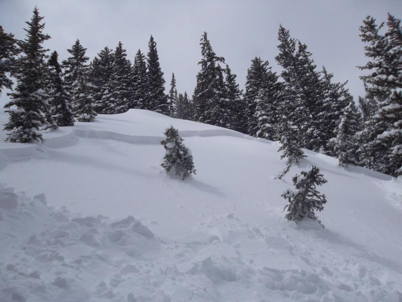
current conditions This amazing spring storm is finally over. Storm totals are just over 2 feet at Alta with lots of smiles yesterday for a great powder day. Skies were clear overnight. Temperatures are in the mid teens this morning and the ridge top winds have finally, mercifully died down but still blowing from the north and northwest 15 mph on most ridges and 25 on the high peaks. Today should be a great day to get out and view the many avalanches that occurred yesterday. Remember, you can always check current conditions for yourself at the National Weather Service Snow Page.
|
 |
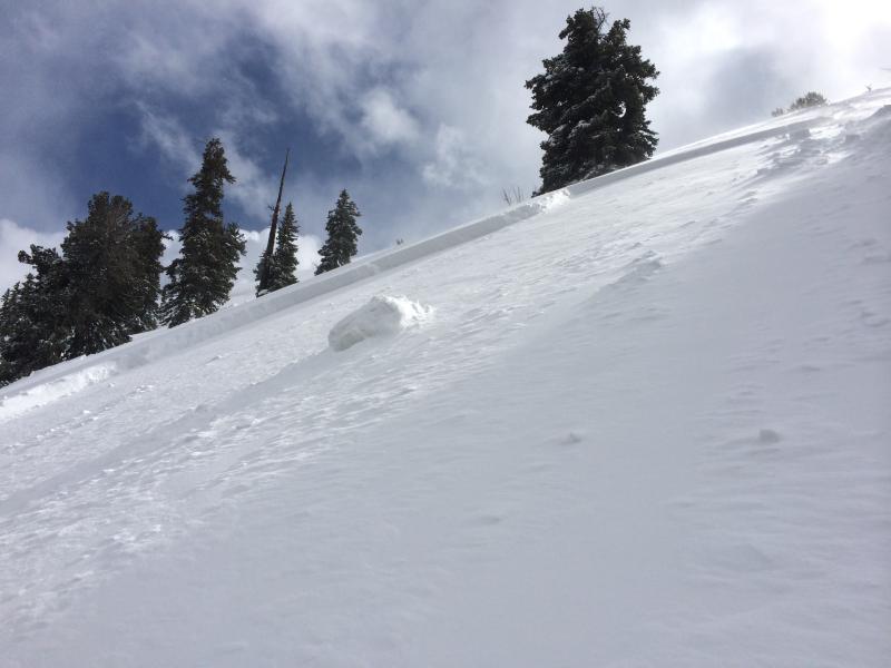
recent activity Yikes. We have a very long list of human triggered avalanches from yesterday, which are posted in the Detailed Info section, perhaps the most activity in a day this season. I count eight avalanche observations with over a dozen human triggered avalanches and that's not counting a couple more late obs posted from avalanches triggered the day before. A couple people were caught and lost some equipment (Cardiff Bowl and Patsy Marly). One person reported 4 different remotely-triggered avalanches in Days Fork. But luckily everyone came home wiser. All these avalanches were wind slabs and storm slabs within the new snow running either on density inversions within the new snow or the old snow surface. Most broke out 1-2 feet deep and most were quite sensitive.
Silver Fork
Day's Fork |
| type | aspect/elevation | characteristics |
|---|

|
|
LIKELIHOOD
 LIKELY
UNLIKELY
SIZE
 LARGE
SMALL
TREND
 INCREASING DANGER
SAME
DECREASING DANGER
|
|
description
Note: the danger rose is all grey because we are not publishing danger ratings this time of year. I'm guessing that many of the instabilities within the new snow have settled out overnight and slabs will be less sensitive today. But with reports of remotely-triggered slabs from yesterday, Plus the cold temperatures, I'm suspicious that you can find some lingering hazard today. Obviously, yesterday, many people ignored my advice to avoid steep slopes so I don't expect that people will pay much more attention today. But you should continue to avoid steep slopes with recent wind deposits, continually jump on small test slopes as you travel to test how well the new snow is bonded and always put in a good slope cut before committing to a slope.
|
| type | aspect/elevation | characteristics |
|---|

|

|
LIKELIHOOD
LIKELY
UNLIKELY
SIZE
LARGE
SMALL
TREND
INCREASING DANGER
SAME
DECREASING DANGER
|
|
description
The sun is high in the sky this time of year, so expect the usual round of wet sluffs and soft slabs released by sudden warming as the cold, dry snow warms up for the first time. Stay off of, and out from underneath, steep sun exposed slopes as they warm up today. |
 |
weather Sunny skies all week! What's not to like. 8,000' temperatures should warm up to freezing and ridge top temperatures should warm into the 20's. Ridge top wind will blow 20 mph from the north and northwest. We will thankfully have a very slow warm up for the rest of the week. Be sure to monitor the latest weather conditions before heading out. Here are a few of my favorite sources: Cottonwood Canyons Forecast from the National Weather Service |
| general announcements Remember your information can save lives. If you see anything we should know about, please participate in the creation of our own community avalanche advisory by submitting snow and avalanche conditions. You can also call us at 801-524-5304 or 800-662-4140, email by clicking HERE, or include #utavy in your tweet or Instagram. If you trigger an avalanche in the backcountry - especially if you are adjacent to a ski area – please call the following teams to alert them to the slide and whether anyone is missing or not. Rescue teams can be exposed to significant hazard when responding to avalanches, and do not want to do so when unneeded. Thanks. Salt Lake and Park City – Alta Central (801-742-2033), Canyons Resort Dispatch (435-615-3322) EMAIL ADVISORY We have switched to a new SLC email advisory system. If you would like to get the daily advisory by email, or if you have been getting the advisory by email since the beginning of the season and wish to continue, you will need to subscribe here. Twitter Updates for your mobile phone - DETAILS UDOT canyon closures: LINK TO UDOT Utah Avalanche Center mobile app - Get your advisory on your iPhone along with great navigation and rescue tools.uned. Lost or Found something in the backcountry? - http://nolofo.com/ To those skinning uphill at resorts: it is your responsibility to know the resort policy on uphill travel. Some allow uphill travel and have guidelines, some don't. Contact the Ski Patrol at each resort for details. IMPORTANT: Before skinning at a resort under new snow conditions, check in with Ski Patrol. Resorts can restrict or cut off access if incompatible with control and grooming operations. Benefit the Utah Avalanche Center when you shop from Backcountry.com or REI: Click this link for Backcountry.com or this link to REI, shop, and they will donate a percent of your purchase price to the UAC. Both offer free shipping (with some conditions) so this costs you nothing! Benefit the Utah Avalanche Center when you buy or sell on ebay - set the Utah Avalanche Center as a favorite non-profit in your ebay account here and click on ebay gives when you buy or sell. You can choose to have your seller fees donated to the UAC, which doesn't cost you a penny. This information does not apply to developed ski areas or highways where avalanche control is normally done. This advisory is from the U.S.D.A. Forest Service, which is solely responsible for its content. This advisory describes general avalanche conditions and local variations always exist. |