| During the month of April, Mark Miller will donate $75 to the charity of your choice (5 to chose from, including the Utah Avalanche Center!) Mark Miller Subaru has raised over $300k in the previous 6 Do Good Feel Good events. More Info here |  |
| During the month of April, Mark Miller will donate $75 to the charity of your choice (5 to chose from, including the Utah Avalanche Center!) Mark Miller Subaru has raised over $300k in the previous 6 Do Good Feel Good events. More Info here | |
| Advisory: Salt Lake Area Mountains | Issued by Brett Kobernik for Saturday - April 12, 2014 - 6:30am |
|---|

|
bottom line The overall avalanche danger is MODERATE today. There is a low probability of getting caught in a wet avalanche but the consequences are high. If you're considering a significant outing in the high country, it may be better to wait until temperatures cool down on Sunday.
|
 |
special announcement The Utah Avalanche Center is winding down for the season - we'll do early morning forecasts through this weekend (Sunday April 13th) and then issue intermittent advisories through the end of April. |
 |
current conditions It was the fourth night in a row of overnight low temperature readings well above freezing. Most locations were around 40 degrees with a low of 36 degrees at 11,000 feet. Winds are generally light from the southwest. |
 |
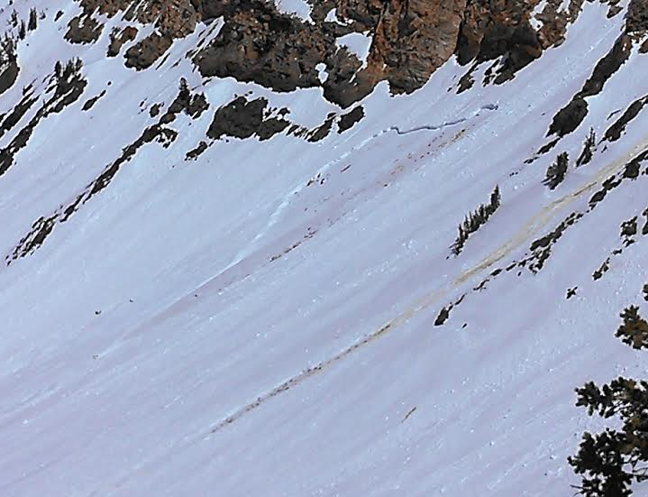
recent activity There was a wet slab avalanche reported from Mineral Fork (Room of Doom) on Friday but timing on it's release is unknown. It's suspected to have released earlier Friday or perhaps Thursday. DETAILS There was also some more loose wet activity reported from Friday. Below is south facing Mt Superior in Little Cottonwood Canyon. |
| type | aspect/elevation | characteristics |
|---|

|
|
LIKELIHOOD
 LIKELY
UNLIKELY
SIZE
 LARGE
SMALL
TREND
 INCREASING DANGER
SAME
DECREASING DANGER
|
|
description
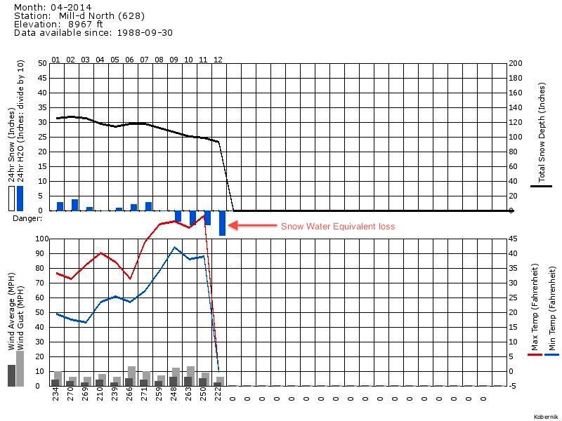
In theory, today's cloud cover should slow wet avalanche activity. However, with four nights in a row of above freezing temperatures and lots of water percolating through the pack, it's hard to trust many slopes. Below is a chart of the Mill D North Snotel site which shows a loss of snow water equivalent over the last four days. I'd avoid being on or below many steep slopes today especially in thin snowpack areas as well as in areas known for glide avalanches such as Stairs and Broads Fork.
|
 |
weather We'll see some clouds today with 8000 foot high temperatures around 50 and in the 40s along the ridgetops. Westerly winds will be in the light to moderate speed category. There's a slight chance for a snow flurry. A storm will move through tonight producing some accumulations in the 2 to 5 inch range with much colder temperatures. High pressure returns early in the week with another cold front on Wednesday. |
| general announcements Remember your information can save lives. If you see anything we should know about, please participate in the creation of our own community avalanche advisory by submitting snow and avalanche conditions. You can also call us at 801-524-5304 or 800-662-4140, email by clicking HERE, or include #utavy in your tweet or Instagram. If you trigger an avalanche in the backcountry - especially if you are adjacent to a ski area – please call the following teams to alert them to the slide and whether anyone is missing or not. Rescue teams can be exposed to significant hazard when responding to avalanches, and do not want to do so when unneeded. Thanks. Salt Lake and Park City – Alta Central (801-742-2033), Canyons Resort Dispatch (435-615-3322) Snowbasin Resort Dispatch (801-620-1017), Powder Mountain Dispatch (801-745-3772 x 123). Sundance Dispatch (801-223-4150) EMAIL ADVISORY We have switched to a new SLC email advisory system. If you would like to get the daily advisory by email, or if you have been getting the advisory by email since the beginning of the season and wish to continue, you will need to subscribe here. DAWN PATROL Hotline updated daily by 5-530am - 888-999-4019 option 8. Twitter Updates for your mobile phone - DETAILS UDOT canyon closures: LINK TO UDOT Utah Avalanche Center mobile app - Get your advisory on your iPhone along with great navigation and rescue tools.uned. Wasatch Powderbird Guides Blog/Itinerary for the Day. Lost or Found something in the backcountry? - http://nolofo.com/ Discount lift tickets are now available at Backcountry.com - Thanks to Ski Utah and the Utah Resorts. All proceeds go towards paying for Utah Avalanche Center avalanche and mountain weather advisories. To those skinning uphill at resorts: it is your responsibility to know the resort policy on uphill travel. Some allow uphill travel and have guidelines, some don't. Contact the Ski Patrol at each resort for details. IMPORTANT: Before skinning at a resort under new snow conditions, check in with Ski Patrol. Resorts can restrict or cut off access if incompatible with control and grooming operations. Benefit the Utah Avalanche Center when you shop from Backcountry.com or REI: Click this link for Backcountry.com or this link to REI, shop, and they will donate a percent of your purchase price to the UAC. Both offer free shipping (with some conditions) so this costs you nothing! Benefit the Utah Avalanche Center when you buy or sell on ebay - set the Utah Avalanche Center as a favorite non-profit in your ebay account here and click on ebay gives when you buy or sell. You can choose to have your seller fees donated to the UAC, which doesn't cost you a penny. This information does not apply to developed ski areas or highways where avalanche control is normally done. This advisory is from the U.S.D.A. Forest Service, which is solely responsible for its content. This advisory describes general avalanche conditions and local variations always exist. |