| During the month of April, Mark Miller will donate $75 to the charity of your choice (5 to chose from, including the Utah Avalanche Center!) Mark Miller Subaru has raised over $300k in the previous 6 Do Good Feel Good events. More Info here |  |
| During the month of April, Mark Miller will donate $75 to the charity of your choice (5 to chose from, including the Utah Avalanche Center!) Mark Miller Subaru has raised over $300k in the previous 6 Do Good Feel Good events. More Info here | |
| Advisory: Salt Lake Area Mountains | Issued by Drew Hardesty for Wednesday - April 9, 2014 - 6:49am |
|---|

|
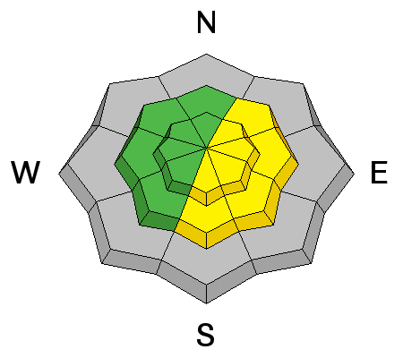
bottom line With direct sun and skyrocketing temperatures, the danger will rise to CONSIDERABLE on and beneath all of the steep sunlit slopes today. Natural and human triggered wet loose and wet slab avalanches are likely during and just after the heat of the day. Depending on cloud cover, I'd expect some significant activity today. Heating will also affect many northerly slopes as well - avoid being in or above terrain traps in steep northerly low to mid-elevation terrain. A pockety MODERATE danger exists for lingering wind and storm snow avalanches in the northeast to south facing terrain above about 9000'.
|
 |
special announcement We'll forecast through this weekend and then issue intermittent advisories through the end of April. This is my last daily advisory for the season and while Bruce will compile a more formal list to thank this weekend, I wanted to give a few words of thanks for various folks.
|
 |
current conditions These temperatures are not a good thing. Nor is the blanket of high, at-times thicker waves of cirrus clouds that cloak the upper levels of the stratosphere, holding in some of the heat. Indeed we are perhaps at or very near record warm overnight temperatures both in the valleys and in the mountains for this time of year. Current temps are in the upper 30s to mid 40s in the Cottonwoods, the upper 30s to upper 40s along the Park City ridgeline and in the Provo and Ogden area mountains. The winds picked up a touch from the west/southwest in the early hours this morning and are blowing 15-20mph with gusts to 30. Any vestiges of supportable crusts will be short-lived this morning...and I suspect even the higher elevation (up to 10K+?) northerly aspects may have been affected by the heat.
|
 |
recent activity Some of the steepest, sustained and confined avalanche paths above LCC released naturally with yesterday's direct sun and heating, again leaving decent debris piles in the transition zone. Explosive work in the upper Cottonwoods also yielded some results in lingering wind/storm slabs in high north to easterly terrain. Details are sketchy, but we did hear of one other skier triggered dry snow wind slab in steep high terrain along the Cottonwood ridgeline (southeast facing at roughly 11,000'). |
| type | aspect/elevation | characteristics |
|---|

|
|
LIKELIHOOD
 LIKELY
UNLIKELY
SIZE
 LARGE
SMALL
TREND
 INCREASING DANGER
SAME
DECREASING DANGER
|
|
description
Warmer overnight "lows", direct sun, skyrocketing temps, and insult-to-injury potential for afternoon green-housing will have an earlier and perhaps more significant wet avalanche activity today. Wet loose avalanches will be possible on all aspects...and with some level of percolating melt-water, wet slab avalanches possible on east to south to west facing slopes. It'll still be possible for loose wet point releases to pry out slow-to-heal storm snow down to the Thurs/Friday crust, similarly resulting in slab avalanche pockets. Debris piles may be again significant below steep, sustained, confined terrain. Don't overlook the effect the heat will have on the steep northerly terrain that still held cold dry snow from the weekend...the steep north facing gullies and terrain traps should be avoided once the snow becomes damp...certainly the mid and low elevation terrain...though damp loose slides may be possible near the higher elevations as well. |
| type | aspect/elevation | characteristics |
|---|

|
|
LIKELIHOOD
 LIKELY
UNLIKELY
SIZE
LARGE
SMALL
TREND
INCREASING DANGER
SAME
DECREASING DANGER
|
|
description
The weekend's storm snow bonded poorly to the Thurs/Friday snow surfaces that harbored some small grain faceted snow above a melt-freeze crust. Additional stress in the form of wind drifting and direct sun/solar radiation induced creep (~downhill flow of the snow) hasn't allowed the "epoxy to set" or "glue to dry" among this interface...and I'll wager that a few more isolated pockets can be triggered today in similar fashion to yesterday. These will be most prominent on south and southeast facing slopes above 9000', give or take.... Loose wet point releases are likely to pry out slow-to-heal storm snow down to the Thurs/Friday crust, resulting in slab avalanche pockets as well. |
| type | aspect/elevation | characteristics |
|---|

|
|
LIKELIHOOD
 LIKELY
UNLIKELY
SIZE
 LARGE
SMALL
TREND
INCREASING DANGER
SAME
DECREASING DANGER
|
|
description
CORNICES -
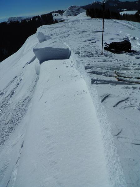
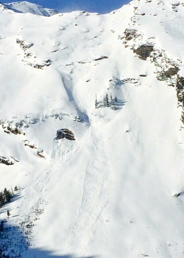
It's that time of year where the large overhanging cornices collapse due to their own weight, pulling well beyond the apex of the ridgeline. Note Mark White's photo where even someone standing on the ridge could have the carpet pulled out from underneath them. I'd call this a hybrid cornice/slab.... GLIDE SLAB AVALANCHE (recent pic Tom Diegel) - as with cornices, it's that time of year to avoid runout zones beneath the classic glide slab avalanche terrain in Stairs, Broads, and areas of Mill B South).
|
 |
weather Mostly sunny skies will prevail with increasing west to southwesterly winds in the 20-25mph range. Temp today will be in the 60 degree range at 8000' and the near 50 at 10,000'. Increasing thick high clouds with some virga will be likely ahead of this evening's "cool-frontal boundary" (I suppose by definition you could call it a cold front) that'll drop temps a few degrees...though the temps will again rebound for Friday. The weekend looks potentially unsettled, though the models are still not aligned toward a definite solution. More info on our mountain weather forecast out by midday/early afternoon. |
| general announcements
Remember your information can save lives. If you see anything we should know about, please participate in the creation of our own community avalanche advisory by submitting snow and avalanche conditions. You can also call us at 801-524-5304 or 800-662-4140, email by clicking HERE, or include #utavy in your tweet or Instagram. If you trigger an avalanche in the backcountry - especially if you are adjacent to a ski area – please call the following teams to alert them to the slide and whether anyone is missing or not. Rescue teams can be exposed to significant hazard when responding to avalanches, and do not want to do so when unneeded. Thanks. Salt Lake and Park City – Alta Central (801-742-2033), Canyons Resort Dispatch (435-615-3322) Snowbasin Resort Dispatch (801-620-1017), Powder Mountain Dispatch (801-745-3772 x 123). Sundance Dispatch (801-223-4150) EMAIL ADVISORY We have switched to a new SLC email advisory system. If you would like to get the daily advisory by email, or if you have been getting the advisory by email since the beginning of the season and wish to continue, you will need to subscribe here. DAWN PATROL Hotline updated daily by 5-530am - 888-999-4019 option 8. Twitter Updates for your mobile phone - DETAILS UDOT canyon closures: LINK TO UDOT Utah Avalanche Center mobile app - Get your advisory on your iPhone along with great navigation and rescue tools.uned. Wasatch Powderbird Guides Blog/Itinerary for the Day. Lost or Found something in the backcountry? - http://nolofo.com/ Discount lift tickets are now available at Backcountry.com - Thanks to Ski Utah and the Utah Resorts. All proceeds go towards paying for Utah Avalanche Center avalanche and mountain weather advisories. To those skinning uphill at resorts: it is your responsibility to know the resort policy on uphill travel. Some allow uphill travel and have guidelines, some don't. Contact the Ski Patrol at each resort for details. IMPORTANT: Before skinning at a resort under new snow conditions, check in with Ski Patrol. Resorts can restrict or cut off access if incompatible with control and grooming operations. Benefit the Utah Avalanche Center when you shop from Backcountry.com or REI: Click this link for Backcountry.com or this link to REI, shop, and they will donate a percent of your purchase price to the UAC. Both offer free shipping (with some conditions) so this costs you nothing! Benefit the Utah Avalanche Center when you buy or sell on ebay - set the Utah Avalanche Center as a favorite non-profit in your ebay account here and click on ebay gives when you buy or sell. You can choose to have your seller fees donated to the UAC, which doesn't cost you a penny. This information does not apply to developed ski areas or highways where avalanche control is normally done. This advisory is from the U.S.D.A. Forest Service, which is solely responsible for its content. This advisory describes general avalanche conditions and local variations always exist. |