
| During the month of April, Mark Miller will donate $75 to the charity of your choice (5 to chose from, including the Utah Avalanche Center!) Mark Miller Subaru has raised over $300k in the previous 6 Do Good Feel Good events. More Info here |  |
| During the month of April, Mark Miller will donate $75 to the charity of your choice (5 to chose from, including the Utah Avalanche Center!) Mark Miller Subaru has raised over $300k in the previous 6 Do Good Feel Good events. More Info here | |
| Advisory: Salt Lake Area Mountains | Issued by Brett Kobernik for Saturday - March 29, 2014 - 6:32am |
|---|

|
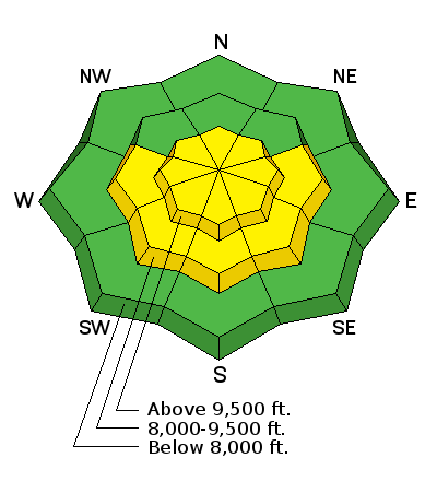
bottom line The overall avalanche danger today is MODERATE. Areas of concern are steep slopes with recent deposits of wind drifted snow as well as steep slopes that become excessively wet from daytime heating.
|
 |
special announcement SALE! on all remaining discount lift tickets donated to the Utah Avalanche Center from Snowbasin, the Canyons, Beaver Mountain, Sundance, and Brian Head: The few remaining tickets are being blown out with all proceeds used to pay for avalanche advisories and education. Go here to get your tickets. |
 |
current conditions After Thursday's storm, temperatures warmed Friday in typical Spring fashion with east, south and west aspects becoming damp by mid day. Intermittent cloud cover did help the sunny aspects from becoming too wet and unstable. Overnight, temperatures were in the mid to upper 20s and southerly winds have increased a bit. |
 |
recent activity The wind slabs that were sensitive during the storm became less so on Friday but there were a few that were triggered by skiers including one that caught and carried a skier a short distance without incident. (DETAILS - MINERAL FORK) The heating during the day also produced a couple of heat initiated avalanches. (DETAILS - W MONITOR) Overall, things were fairly well behaved. |
| type | aspect/elevation | characteristics |
|---|

|
|
LIKELIHOOD
 LIKELY
UNLIKELY
SIZE
 LARGE
SMALL
TREND
 INCREASING DANGER
SAME
DECREASING DANGER
|
|
description
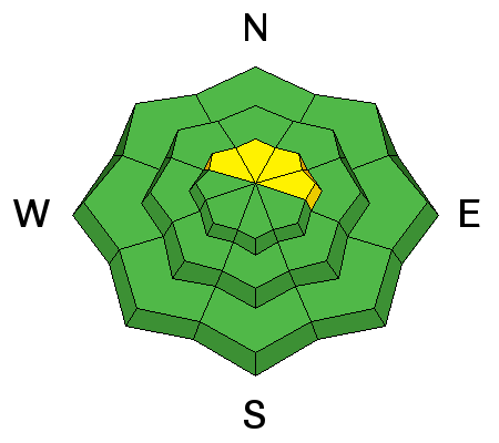
You'll need to watch for the same issues today as were present yesterday, the first being wind slabs. There may be a few pockets which formed during the last storm that could be triggered still. Also, anticipated south winds today could form some fresh sensitive drifts along the lee sides of the higher ridges. |
| type | aspect/elevation | characteristics |
|---|

|
|
LIKELIHOOD
LIKELY
UNLIKELY
SIZE
LARGE
SMALL
TREND
 INCREASING DANGER
SAME
DECREASING DANGER
|
|
description
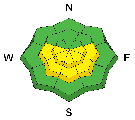
Heat related avalanche activity should also be considered today. Winds and cloud cover should keep this problem at bay for the most part but air temperatures are going to be warm enough to keep this issue on our minds. |
 |
weather Expect warm and windy conditions today with some cloud cover. 8000 foot temperatures should be around 40 and in the 30s along the ridges. Southwest winds should increase in speed a bit more into the moderate category with some stronger gusts. The next storm is still shaping up for Sunday with a cold front moving through during the morning or mid day and snowfall lasting into Sunday night. We could see up to around a foot of snow. More periods of snow are anticipated through next week. |
| general announcements Remember your information can save lives. If you see anything we should know about, please participate in the creation of our own community avalanche advisory by submitting snow and avalanche conditions. You can also call us at 801-524-5304 or 800-662-4140, email by clicking HERE, or include #utavy in your tweet or Instagram. If you trigger an avalanche in the backcountry - especially if you are adjacent to a ski area – please call the following teams to alert them to the slide and whether anyone is missing or not. Rescue teams can be exposed to significant hazard when responding to avalanches, and do not want to do so when unneeded. Thanks. Salt Lake and Park City – Alta Central (801-742-2033), Canyons Resort Dispatch (435-615-3322) Snowbasin Resort Dispatch (801-620-1017), Powder Mountain Dispatch (801-745-3772 x 123). Sundance Dispatch (801-223-4150) EMAIL ADVISORY We have switched to a new SLC email advisory system. If you would like to get the daily advisory by email, or if you have been getting the advisory by email since the beginning of the season and wish to continue, you will need to subscribe here. DAWN PATROL Hotline updated daily by 5-530am - 888-999-4019 option 8. Twitter Updates for your mobile phone - DETAILS UDOT canyon closures: LINK TO UDOT Utah Avalanche Center mobile app - Get your advisory on your iPhone along with great navigation and rescue tools.uned. Wasatch Powderbird Guides Blog/Itinerary for the Day. Lost or Found something in the backcountry? - http://nolofo.com/ Discount lift tickets are now available at Backcountry.com - Thanks to Ski Utah and the Utah Resorts. All proceeds go towards paying for Utah Avalanche Center avalanche and mountain weather advisories. To those skinning uphill at resorts: it is your responsibility to know the resort policy on uphill travel. Some allow uphill travel and have guidelines, some don't. Contact the Ski Patrol at each resort for details. IMPORTANT: Before skinning at a resort under new snow conditions, check in with Ski Patrol. Resorts can restrict or cut off access if incompatible with control and grooming operations. Benefit the Utah Avalanche Center when you shop from Backcountry.com or REI: Click this link for Backcountry.com or this link to REI, shop, and they will donate a percent of your purchase price to the UAC. Both offer free shipping (with some conditions) so this costs you nothing! Benefit the Utah Avalanche Center when you buy or sell on ebay - set the Utah Avalanche Center as a favorite non-profit in your ebay account here and click on ebay gives when you buy or sell. You can choose to have your seller fees donated to the UAC, which doesn't cost you a penny. This information does not apply to developed ski areas or highways where avalanche control is normally done. This advisory is from the U.S.D.A. Forest Service, which is solely responsible for its content. This advisory describes general avalanche conditions and local variations always exist. |


