
| During the month of April, Mark Miller will donate $75 to the charity of your choice (5 to chose from, including the Utah Avalanche Center!) Mark Miller Subaru has raised over $300k in the previous 6 Do Good Feel Good events. More Info here |  |
| During the month of April, Mark Miller will donate $75 to the charity of your choice (5 to chose from, including the Utah Avalanche Center!) Mark Miller Subaru has raised over $300k in the previous 6 Do Good Feel Good events. More Info here | |
| Advisory: Salt Lake Area Mountains | Issued by Evelyn Lees for Thursday - March 27, 2014 - 6:43am |
|---|


|
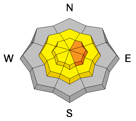
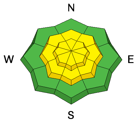
bottom line The AVALANCHE DANGER will rise to CONSIDERABLE on steep, wind drifted slopes as the snow piles up today, with natural avalanches possible in areas receiving the additional 6 to 10” of snow accompanied by strong winds. Human triggered avalanches will be likely on these steep wind drifted slopes. Out of the wind affected terrain, the avalanche danger will rise to MODERATE for triggering new snow sluffs and soft slabs on steep slopes of all aspects.
|
 |
special announcement Tonight, Thursday, Mar 27th, Liam Fitzgerald will be the final speaker at the Utah Adventure Journal series, talking about avalanche control in Little Cottonwood Canyon and the avalanche control program in the early days of Snowbird. Liam was the first snow safety director at Snowbird and has been an avalanche professional in Little Cottonwood ever since. Liam will be sharing stories and lessons learned from avalanche assessment and control over 45 years. There is a suggested small donation to the Utah Avalanche Center which includes a raffle for great donated gear and happy hour food and drink specials. 6pm, Wildflower Lounge, 21+ SALE! on all remaining discount lift tickets donated to the Utah Avalanche Center from Snowbasin, the Canyons, Beaver Mountain, Sundance, and Brian Head: The few remaining tickets are being blown out with all proceeds used to pay for avalanche advisories and education. Go here to get your tickets. |
 |
current conditions In many locations, light snow has started to fall again as the second piece of the storm approaches. Snow totals as of this morning are in the 5 to 9” range at the upper elevations in the Cottonwoods, 2 to 4” on the Park City side and the Ogden area mountains, and about 6 inches in the Provo mountains. Temperatures are in the upper teens at 10,000’. Winds are from a westerly direction, and overnight were in the 25 to 35 mph range across the high ridgelines, gusting into the 50s. |
 |
recent activity Reports yesterday were of sluffs and very shallow (2-4 inch) soft slabs, some quite sensitive and fast running. |
| type | aspect/elevation | characteristics |
|---|

|
|
LIKELIHOOD
 LIKELY
UNLIKELY
SIZE
 LARGE
SMALL
TREND
 INCREASING DANGER
SAME
DECREASING DANGER
|
|
description
If the weather forecast verifies – an additional 6 to 10” of snow accompanied by moderate to strong westerly winds – new snow wind drifts 1 to 2 feet deep will develop, and become easy to trigger. They will be especially widespread on upper elevation, northeast, east and southeasterly facing slopes. However, the winds are channeled by the terrain in the mountains, and can end up drifting snow onto a surprising variety of aspects and elevations. So identify the rounded, pillowy wind drifts where ever they are, and avoid them on all steep slopes.
Cornices are sensitive these days, and almost always break off further back than expected. Stay well back from the edges, and don’t dawdle beneath them. |
| type | aspect/elevation | characteristics |
|---|

|
|
LIKELIHOOD
 LIKELY
UNLIKELY
SIZE
LARGE
SMALL
TREND
INCREASING DANGER
SAME
DECREASING DANGER
|
|
description
Out of the wind affected terrain, it will be possible to trigger new snow sluffs and soft slabs on steep slopes. The sensitivity of the new snow will spike during periods of heavy snowfall. With the old, hard bed surfaces beneath on many slopes, some of these slides may run further and faster than expected. |
 |
weather Light to moderate snow is expected much of the day, with the heaviest snowfall expected between 9 am and 1 pm. An additional 6 to 10” of snow is possible in the Cottonwoods, with about 4 to 8” expected elsewhere. The westerly winds are forecast to pick up again along the high ridges, with hourly averages to 35 mph, gusting to 60 mph. Even the lower ridgelines could have 20 to 30 mph averages at times, with gusts in the 40s, and these moderate wind speeds should continue through the night. 10,000’ temperatures will remain in the mid-teens today. Spring time convection this afternoon will produce a 25% chance of lightning. Then it’s a classic spring forecast, with a roller coaster of temperatures and snow. Temperatures will start to warm rapidly Friday afternoon, reaching the mid-30s at 10,000’ by Saturday afternoon ahead of the next storm. This quick mover will bring a small shot of snow Saturday night. Another cooler storm is possible around next Tuesday. |
| general announcements Remember your information can save lives. If you see anything we should know about, please participate in the creation of our own community avalanche advisory by submitting snow and avalanche conditions. You can also call us at 801-524-5304 or 800-662-4140, email by clicking HERE, or include #utavy in your tweet or Instagram. If you trigger an avalanche in the backcountry - especially if you are adjacent to a ski area – please call the following teams to alert them to the slide and whether anyone is missing or not. Rescue teams can be exposed to significant hazard when responding to avalanches, and do not want to do so when unneeded. Thanks. Salt Lake and Park City – Alta Central (801-742-2033), Canyons Resort Dispatch (435-615-3322) Snowbasin Resort Dispatch (801-620-1017), Powder Mountain Dispatch (801-745-3772 x 123). Sundance Dispatch (801-223-4150) EMAIL ADVISORY We have switched to a new SLC email advisory system. If you would like to get the daily advisory by email, or if you have been getting the advisory by email since the beginning of the season and wish to continue, you will need to subscribe here. DAWN PATROL Hotline updated daily by 5-530am - 888-999-4019 option 8. Twitter Updates for your mobile phone - DETAILS UDOT canyon closures: LINK TO UDOT Utah Avalanche Center mobile app - Get your advisory on your iPhone along with great navigation and rescue tools.uned. Wasatch Powderbird Guides Blog/Itinerary for the Day. Lost or Found something in the backcountry? - http://nolofo.com/ Discount lift tickets are now available at Backcountry.com - Thanks to Ski Utah and the Utah Resorts. All proceeds go towards paying for Utah Avalanche Center avalanche and mountain weather advisories. To those skinning uphill at resorts: it is your responsibility to know the resort policy on uphill travel. Some allow uphill travel and have guidelines, some don't. Contact the Ski Patrol at each resort for details. IMPORTANT: Before skinning at a resort under new snow conditions, check in with Ski Patrol. Resorts can restrict or cut off access if incompatible with control and grooming operations. Benefit the Utah Avalanche Center when you shop from Backcountry.com or REI: Click this link for Backcountry.com or this link to REI, shop, and they will donate a percent of your purchase price to the UAC. Both offer free shipping (with some conditions) so this costs you nothing! Benefit the Utah Avalanche Center when you buy or sell on ebay - set the Utah Avalanche Center as a favorite non-profit in your ebay account here and click on ebay gives when you buy or sell. You can choose to have your seller fees donated to the UAC, which doesn't cost you a penny. This information does not apply to developed ski areas or highways where avalanche control is normally done. This advisory is from the U.S.D.A. Forest Service, which is solely responsible for its content. This advisory describes general avalanche conditions and local variations always exist. |


