| During the month of April, Mark Miller will donate $75 to the charity of your choice (5 to chose from, including the Utah Avalanche Center!) Mark Miller Subaru has raised over $300k in the previous 6 Do Good Feel Good events. More Info here |  |
| During the month of April, Mark Miller will donate $75 to the charity of your choice (5 to chose from, including the Utah Avalanche Center!) Mark Miller Subaru has raised over $300k in the previous 6 Do Good Feel Good events. More Info here | |
| Advisory: Salt Lake Area Mountains | Issued by Bruce Tremper for Friday - March 21, 2014 - 5:51am |
|---|

|
bottom line Most of the backcountry has a LOW avalanche danger. Low danger never means no danger. Today you could find: 1) lingering, shallow, wind slabs in upper elevation terrain, 2) shallow wet sluffs in steep terrain with daytime heating, 3) sensitive cornices along ridges.
|
 |
special announcement SALE! on all remaining discount lift tickets donated to the Utah Avalanche Center from Beaver Mountain, Wolf Mountain, Sundance, and Brian Head: The few remaining tickets are being blown out with all proceeds used to pay for avalanche advisories and education. Go here to get your tickets. |
 |
current conditions A weak cold front came through last night so temperatures are slightly colder this morning than yesterday morning. It's in the lower to mid 20's at 9,500' with a 10-15 mph wind from the west. Skies are clear with some scattered higher clouds south of the Wasatch into central Utah. There's still some nice, dense, settled powder on the northerly, wind-sheltered slopes that rides fast. Lots of sun crusts on all the sun exposed terrain and all the upper elevation above-tree-line terrain got blasted by the strong wind from the last storm so it's alternating sastrugi and dense wind deposits.
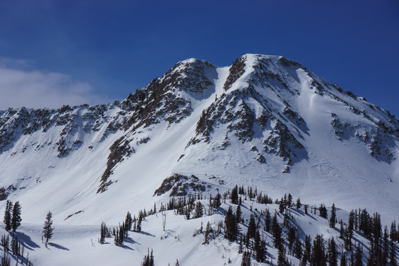
Wind erosion and deposition from the last storm on Lake Peak in upper White Pine drainage. Notice the difference in snow surface texture. The sand blasted snow surface is wind eroded snow (usually safe) and the smooth, rounded snow is wind deposited snow (usually suspect if it was deposited recently). |
 |
recent activity No significant activity reported from yesterday in the backcountry or at the resorts with the exception of some very small, lingering wind slabs and some minor wet, loose activity. |
| type | aspect/elevation | characteristics |
|---|

|
|
LIKELIHOOD
 LIKELY
UNLIKELY
SIZE
 LARGE
SMALL
TREND
 INCREASING DANGER
SAME
DECREASING DANGER
|
|
description
It's mostly low danger on all slopes today with some of the normal cautions including:
|
 |
weather We have a few clouds across central Utah today and some of those may come far enough north to give the Wasatch Range some scattered, high clouds this afternoon. This is part of a weak system that will give us perhaps a few snowflakes tonight into Saturday morning with clearing again by Saturday afternoon. Ridge top winds should remain light 10 mph from the west and southwest and about twice that on the highest peaks. Temperatures should be similar to yesterday but slightly cooler with 20 degrees on the high peaks and rising to the upper 30's down at 8,000'. The extended forecast calls for nice weather through most of the week with another relatively weak storm for around Thursday.
|
| general announcements
Remember your information can save lives. If you see anything we should know about, please participate in the creation of our own community avalanche advisory by submitting snow and avalanche conditions. You can also call us at 801-524-5304 or 800-662-4140, email by clicking HERE, or include #utavy in your tweet or Instagram. If you trigger an avalanche in the backcountry - especially if you are adjacent to a ski area – please call the following teams to alert them to the slide and whether anyone is missing or not. Rescue teams can be exposed to significant hazard when responding to avalanches, and do not want to do so when unneeded. Thanks. Salt Lake and Park City – Alta Central (801-742-2033), Canyons Resort Dispatch (435-615-3322) Snowbasin Resort Dispatch (801-620-1017), Powder Mountain Dispatch (801-745-3772 x 123). Sundance Dispatch (801-223-4150) EMAIL ADVISORY We have switched to a new SLC email advisory system. If you would like to get the daily advisory by email, or if you have been getting the advisory by email since the beginning of the season and wish to continue, you will need to subscribe here. DAWN PATROL Hotline updated daily by 5-530am - 888-999-4019 option 8. Twitter Updates for your mobile phone - DETAILS UDOT canyon closures: LINK TO UDOT Utah Avalanche Center mobile app - Get your advisory on your iPhone along with great navigation and rescue tools.uned. Wasatch Powderbird Guides Blog/Itinerary for the Day. Lost or Found something in the backcountry? - http://nolofo.com/ Discount lift tickets are now available at Backcountry.com - Thanks to Ski Utah and the Utah Resorts. All proceeds go towards paying for Utah Avalanche Center avalanche and mountain weather advisories. To those skinning uphill at resorts: it is your responsibility to know the resort policy on uphill travel. Some allow uphill travel and have guidelines, some don't. Contact the Ski Patrol at each resort for details. IMPORTANT: Before skinning at a resort under new snow conditions, check in with Ski Patrol. Resorts can restrict or cut off access if incompatible with control and grooming operations. Benefit the Utah Avalanche Center when you shop from Backcountry.com or REI: Click this link for Backcountry.com or this link to REI, shop, and they will donate a percent of your purchase price to the UAC. Both offer free shipping (with some conditions) so this costs you nothing! Benefit the Utah Avalanche Center when you buy or sell on ebay - set the Utah Avalanche Center as a favorite non-profit in your ebay account here and click on ebay gives when you buy or sell. You can choose to have your seller fees donated to the UAC, which doesn't cost you a penny. This information does not apply to developed ski areas or highways where avalanche control is normally done. This advisory is from the U.S.D.A. Forest Service, which is solely responsible for its content. This advisory describes general avalanche conditions and local variations always exist. |