| During the month of April, Mark Miller will donate $75 to the charity of your choice (5 to chose from, including the Utah Avalanche Center!) Mark Miller Subaru has raised over $300k in the previous 6 Do Good Feel Good events. More Info here |  |
| During the month of April, Mark Miller will donate $75 to the charity of your choice (5 to chose from, including the Utah Avalanche Center!) Mark Miller Subaru has raised over $300k in the previous 6 Do Good Feel Good events. More Info here | |
| Advisory: Salt Lake Area Mountains | Issued by Drew Hardesty for Thursday - March 20, 2014 - 5:44am |
|---|

|
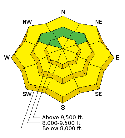
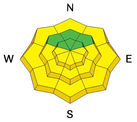
bottom line Most of the backcountry has a LOW avalanche danger. Pockets of MODERATE exist for developing wind drifts in the highest most exposed alpine terrain. Of course, the danger on the steep sunlit slopes will rise to MODERATE with daytime heating.
|
 |
special announcement TODAY - Love Utah Give Utah - Stop by Squatters downtown today between 4 and 6pm for some free snacks, an opportunity to chat with some of the UAC folks, and make an online donation. Can you change Utah in a day? Utah's non-profit community is a big part of what makes living in Utah great. Join your community in a state-wide day of non-profit appreciation and support with Love Utah Give Utah today only. Your donation to the Utah Avalanche Center through this link, large or small, helps pay for avalanche advisories and education and makes the Utah Avalanche Center eligible for challenge grants and special awards provided by local businesses. Free Utah Adventure Journal Speaker Series: March 20 at 6pm: DENNIS TURVILLE: History, first descent stories and modern impacts - A History of Canyoneering at the Wildflower Lounge at Snowbird with a raffle to benefit the Utah Avalanche Center. 21+ SALE! on all remaining discount lift tickets donated to the Utah Avalanche Center from Beaver Mountain, Wolf Mountain, Sundance, and Brian Head: The few remaining tickets are being blown out with all proceeds used to pay for avalanche advisories and education. Go here to get your tickets. |
 |
current conditions Vernal Equinox The magnolia tree has bloomed Last rites of winter? Skies are partly cloudy and morning temps have climbed out of the icebox - they're roughly 15-20 degrees warmer than this time yesterday morning. Winds have picked up a touch, now blowing from the west and southwest at 15-20mph with gusts to 35. 11,000' winds are near 30 with gusts to 40. All but nearly true northerly aspects - and even some low to mid-elevation northerlies - will have a breakable crust this morning. Interested in working on your bump skiing? South Superior is the place to be. |
 |
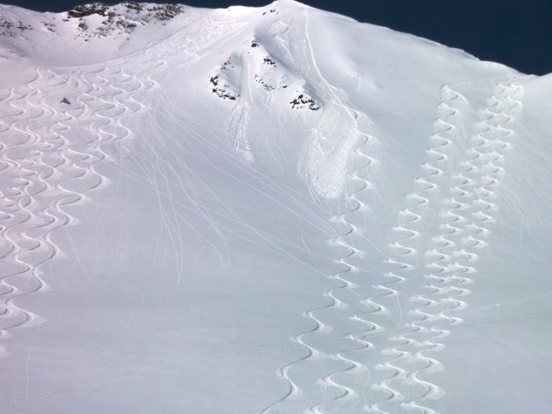
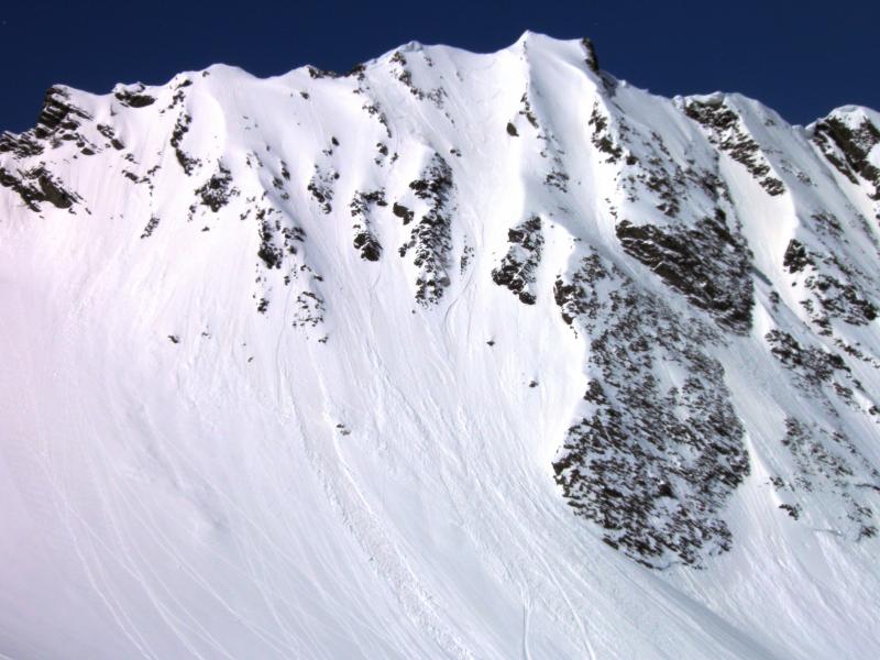
recent activity As is typical just after a nice spring storm, both natural and human triggered wet and dry loose avalanche activity dot the steep landscape, though none significant unless in or under steep confined terrain. (Photos Mark White)
|
| type | aspect/elevation | characteristics |
|---|

|
|
LIKELIHOOD
 LIKELY
UNLIKELY
SIZE
 LARGE
SMALL
TREND
 INCREASING DANGER
SAME
DECREASING DANGER
|
|
description
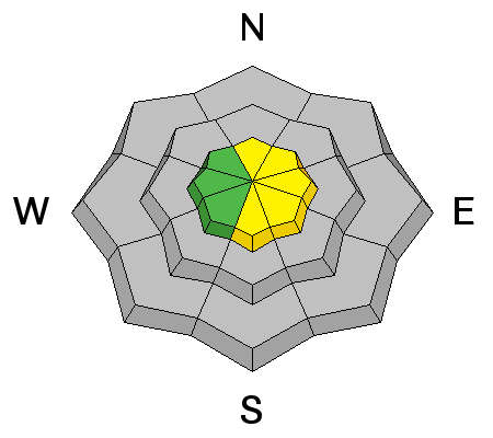
Other than a few developing wind drifts and the clockwork spring wet activity, the danger is fairly low. Just as you look both ways before crossing the street, remember to look to see if anyone is below you before dropping a cornice or throwing in a ski or slope cut. Not unlike at the mountain resorts, downhill folks have the "right of way." |
| type | aspect/elevation | characteristics |
|---|

|
|
LIKELIHOOD
 LIKELY
UNLIKELY
SIZE
LARGE
SMALL
TREND
 INCREASING DANGER
SAME
DECREASING DANGER
|
|
description
Until the recent storm snow bakes down and consolidates - assimilates itself - into the pre-existing snow structure, the diurnal swing into the "melt" phase of the melt-freeze cycle will be prime for wet avalanching during the heat of the day on the steepest sunlit slopes.
|
| type | aspect/elevation | characteristics |
|---|

|
|
LIKELIHOOD
LIKELY
UNLIKELY
SIZE
LARGE
SMALL
TREND
 INCREASING DANGER
SAME
DECREASING DANGER
|
|
description
It'll really be pockety in nature, but take note of some shallow wind slab development if you're pushing into the higher, more radical terrain. |
 |
weather We'll have partly cloudy skies today with temps warming to the low to mid 40s at 8000' and near 30 at 10,000'. Winds will be west to southwesterly at 15-20mph with hourly averages near 30mph along the highest ridgelines. A weak dry cold front moves through this afternoon/eve that is hardly worth a mention. Similarly, a little bit of "weather" that seems to have lost its way off the main storm track will eject through mostly central Utah later Friday into early Saturday. High pressure builds for the remainder of the weekend with perhaps a more progressive weather pattern about a week out. Apparently in Canada, they have the same optimistic 7 day outlook that we do. (Warning - high comedy below). |
| general announcements
Remember your information can save lives. If you see anything we should know about, please participate in the creation of our own community avalanche advisory by submitting snow and avalanche conditions. You can also call us at 801-524-5304 or 800-662-4140, email by clicking HERE, or include #utavy in your tweet or Instagram. If you trigger an avalanche in the backcountry - especially if you are adjacent to a ski area – please call the following teams to alert them to the slide and whether anyone is missing or not. Rescue teams can be exposed to significant hazard when responding to avalanches, and do not want to do so when unneeded. Thanks. Salt Lake and Park City – Alta Central (801-742-2033), Canyons Resort Dispatch (435-615-3322) Snowbasin Resort Dispatch (801-620-1017), Powder Mountain Dispatch (801-745-3772 x 123). Sundance Dispatch (801-223-4150) EMAIL ADVISORY We have switched to a new SLC email advisory system. If you would like to get the daily advisory by email, or if you have been getting the advisory by email since the beginning of the season and wish to continue, you will need to subscribe here. DAWN PATROL Hotline updated daily by 5-530am - 888-999-4019 option 8. Twitter Updates for your mobile phone - DETAILS UDOT canyon closures: LINK TO UDOT Utah Avalanche Center mobile app - Get your advisory on your iPhone along with great navigation and rescue tools.uned. Wasatch Powderbird Guides Blog/Itinerary for the Day. Lost or Found something in the backcountry? - http://nolofo.com/ Discount lift tickets are now available at Backcountry.com - Thanks to Ski Utah and the Utah Resorts. All proceeds go towards paying for Utah Avalanche Center avalanche and mountain weather advisories. To those skinning uphill at resorts: it is your responsibility to know the resort policy on uphill travel. Some allow uphill travel and have guidelines, some don't. Contact the Ski Patrol at each resort for details. IMPORTANT: Before skinning at a resort under new snow conditions, check in with Ski Patrol. Resorts can restrict or cut off access if incompatible with control and grooming operations. Benefit the Utah Avalanche Center when you shop from Backcountry.com or REI: Click this link for Backcountry.com or this link to REI, shop, and they will donate a percent of your purchase price to the UAC. Both offer free shipping (with some conditions) so this costs you nothing! Benefit the Utah Avalanche Center when you buy or sell on ebay - set the Utah Avalanche Center as a favorite non-profit in your ebay account here and click on ebay gives when you buy or sell. You can choose to have your seller fees donated to the UAC, which doesn't cost you a penny. This information does not apply to developed ski areas or highways where avalanche control is normally done. This advisory is from the U.S.D.A. Forest Service, which is solely responsible for its content. This advisory describes general avalanche conditions and local variations always exist. |