| During the month of April, Mark Miller will donate $75 to the charity of your choice (5 to chose from, including the Utah Avalanche Center!) Mark Miller Subaru has raised over $300k in the previous 6 Do Good Feel Good events. More Info here |  |
| During the month of April, Mark Miller will donate $75 to the charity of your choice (5 to chose from, including the Utah Avalanche Center!) Mark Miller Subaru has raised over $300k in the previous 6 Do Good Feel Good events. More Info here | |
| Advisory: Salt Lake Area Mountains | Issued by Drew Hardesty for Tuesday - March 18, 2014 - 6:13am |
|---|


|
bottom line Areas of CONSIDERABLE danger exist in the steep open wind drifted terrain and most pronounced along the north to east to south facing slopes. Human triggered avalanches are probable. All other areas above 8000' will have a MODERATE danger with a note that the danger trend will point toward increasing stability as the day wears on. Collapsing and shooting cracks are key signs of instability. Confidence level in today's advisory is "fair"...and I'd approach steep terrain with extra caution this morning. Safe and better snow conditions can be found in the mid elevation wind sheltered terrain of all aspects on slopes up to 30 degrees in steepness.
|
 |
current conditions Now that's a nice storm for the Wasatch - storm totals are about 12" in upper Little cottonwood, 6-9" in Big Cottonwood, Park City, and Ogden mountains, and about a trace or so in the Provo mountains. Initial small grained graupel and rimed snow crystals gave way to a more classic crystal type that we all know and love - as densities averaged 6% or less as the storm "dried out". Well, we earned it, in a sense, after suffering through the onslaught of hourly wind speeds from the west and northwest of 30-50mph for much of the day yesterday. One recorded gust at 11,000' reached 97mph. Currently, skies are mostly cloudy to overcast with a touch of snowfall here and there at press time at 6am. Winds are north to northwesterly at 15-20mph. Temps are in the single digits to low teens. Overhead, the clouds are beautiful - Clouds trailing streams of virga, like some giant sky-dwelling jellyfish given to the great whims of weather and wind as currents and tides of the sea. |
 |
recent activity Yesterday would've been a good day to work on taxes, clean the oven - you get the idea. My own field work took me to what they call Short Swing, a nice gladed area above Mill D North in Big Cottonwood Canyon. At least I think so - I'd never been there before and visibility was in short supply. We left before there was much to write home about, but the mountain resorts reported a few developing wind drifts here and there as the storm raged on. |
| type | aspect/elevation | characteristics |
|---|

|
|
LIKELIHOOD
 LIKELY
UNLIKELY
SIZE
 LARGE
SMALL
TREND
 INCREASING DANGER
SAME
DECREASING DANGER
|
|
description
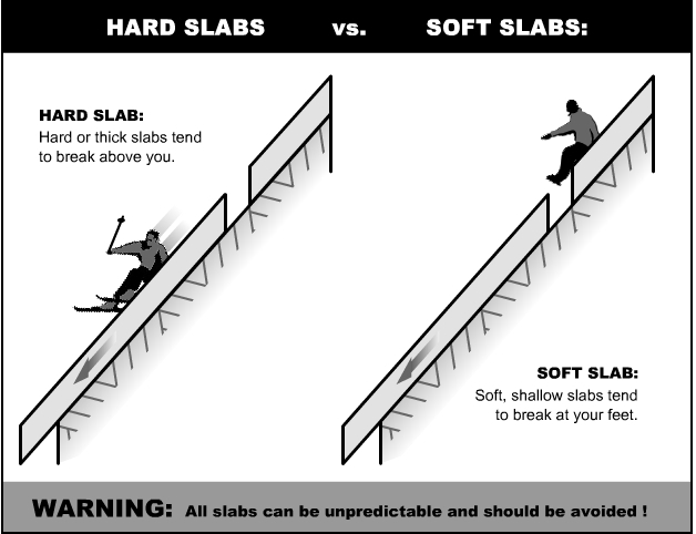
I suspect you'll find it all out there today - shallow pockets of soft drifts here, stiff and stubborn drifts to 2' there and not confined to usual ridgetop loading patterns. They'll be more prominent on north to east to southerly facing aspects at the mid and upper elevations, though scattered by the wind in various locations. You'll have to go slope by slope where each must be judged on its own merit. We often will say "Can be manageable or unmanageable avalanche conditions associated with higher levels of certainty for experienced snow travelers. Extra Caution is advised. Test slopes, ski cuts, previous tracks, and cornice drops may provide some level of information on stability."... and to some degree this depends on whether we're dealing with a soft slab or a hard slab. Remember, soft slabs you're "in", hard slabs you're "on'...and hard slabs will break above you.
|
| type | aspect/elevation | characteristics |
|---|

|

|
LIKELIHOOD
LIKELY
UNLIKELY
SIZE
 LARGE
SMALL
TREND
 INCREASING DANGER
SAME
DECREASING DANGER
|
|
description
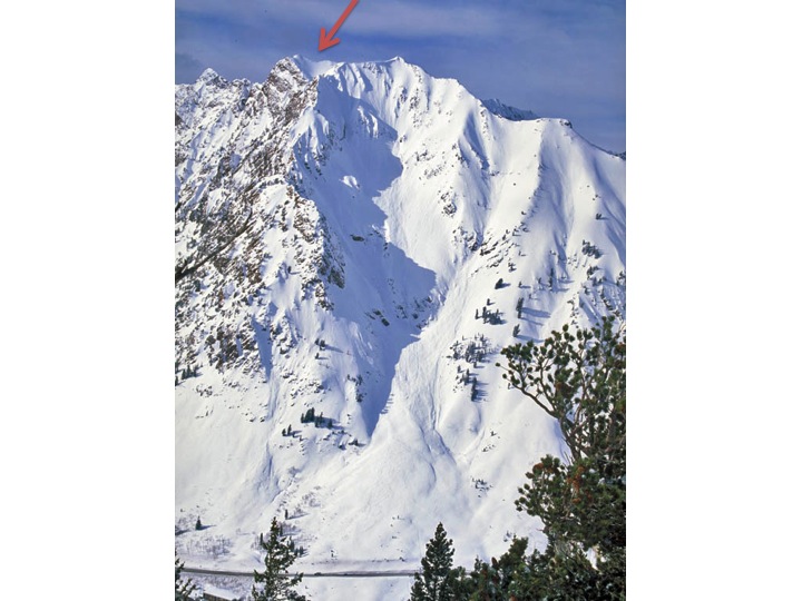
Large cornices cap the high and mid-elevation ridgelines and may be triggered on approach. Like hard slabs, they often break back further than expected, sometimes "this side - the windward side" of the apex of the ridgeline. Cornices are dangerous - you'll need a spotter sometimes to determine where the true edge of the ridgeline is...AND NEVER DROP A CORNICE IF YOU CAN'T SEE DOWN THE SLOPE. A very good friend of mine doing a crown profile in Monte Cristo (see below) years ago had an unintentionally triggered box-car of a cornice hit him directly making for a very close call above radical terrain.
|
| type | aspect/elevation | characteristics |
|---|

|

|
LIKELIHOOD
LIKELY
UNLIKELY
SIZE
 LARGE
SMALL
TREND
 INCREASING DANGER
SAME
DECREASING DANGER
|
|
description
Sluffing is likely with human or solar provocation on the steepest slopes of all aspects. In very steep, sustained pitches, these slides may pack a punch and perhaps pry out storm instabilities in localized terrain. |
 |
weather We'll have mostly-becoming-partly cloudy skies today with some potential for instability showers over localized terrain. Winds will be from the north and northwest at 10-15mph; temps will be in the 15F at 10k and 20-22F range at 8000'. Clearing expected for tonight into tomorrow with a grazing system for Thursday and some unsettled weather for the weekend. |
| general announcements
Remember your information can save lives. If you see anything we should know about, please participate in the creation of our own community avalanche advisory by submitting snow and avalanche conditions. You can also call us at 801-524-5304 or 800-662-4140, email by clicking HERE, or include #utavy in your tweet or Instagram. If you trigger an avalanche in the backcountry - especially if you are adjacent to a ski area – please call the following teams to alert them to the slide and whether anyone is missing or not. Rescue teams can be exposed to significant hazard when responding to avalanches, and do not want to do so when unneeded. Thanks. Salt Lake and Park City – Alta Central (801-742-2033), Canyons Resort Dispatch (435-615-3322) Snowbasin Resort Dispatch (801-620-1017), Powder Mountain Dispatch (801-745-3772 x 123). Sundance Dispatch (801-223-4150) EMAIL ADVISORY We have switched to a new SLC email advisory system. If you would like to get the daily advisory by email, or if you have been getting the advisory by email since the beginning of the season and wish to continue, you will need to subscribe here. DAWN PATROL Hotline updated daily by 5-530am - 888-999-4019 option 8. Twitter Updates for your mobile phone - DETAILS UDOT canyon closures: LINK TO UDOT Utah Avalanche Center mobile app - Get your advisory on your iPhone along with great navigation and rescue tools.uned. Wasatch Powderbird Guides Blog/Itinerary for the Day. Lost or Found something in the backcountry? - http://nolofo.com/ Discount lift tickets are now available at Backcountry.com - Thanks to Ski Utah and the Utah Resorts. All proceeds go towards paying for Utah Avalanche Center avalanche and mountain weather advisories. To those skinning uphill at resorts: it is your responsibility to know the resort policy on uphill travel. Some allow uphill travel and have guidelines, some don't. Contact the Ski Patrol at each resort for details. IMPORTANT: Before skinning at a resort under new snow conditions, check in with Ski Patrol. Resorts can restrict or cut off access if incompatible with control and grooming operations. Benefit the Utah Avalanche Center when you shop from Backcountry.com or REI: Click this link for Backcountry.com or this link to REI, shop, and they will donate a percent of your purchase price to the UAC. Both offer free shipping (with some conditions) so this costs you nothing! Benefit the Utah Avalanche Center when you buy or sell on ebay - set the Utah Avalanche Center as a favorite non-profit in your ebay account here and click on ebay gives when you buy or sell. You can choose to have your seller fees donated to the UAC, which doesn't cost you a penny. This information does not apply to developed ski areas or highways where avalanche control is normally done. This advisory is from the U.S.D.A. Forest Service, which is solely responsible for its content. This advisory describes general avalanche conditions and local variations always exist. |